
5:53PM January 29, 2026
@spann @rzweather @NWSMobile Sunset from Daphne pic.twitter.com/GqbijCEUOn
— Jonathan Thompson (@crimsonscholar) January 29, 2026

@spann @rzweather @NWSMobile Sunset from Daphne pic.twitter.com/GqbijCEUOn
— Jonathan Thompson (@crimsonscholar) January 29, 2026
Fallstreak hole Atmore,AL @spann @NWSMobile @rzweather @ThomasGeboyWX @AlanSealls @CloudAppSoc @WKRGEd @StormHour @ThePhotoHour #alwx #fallstreakhole pic.twitter.com/gGY1gPoxcX
— Ditto Gorme (@dittogorme) January 29, 2026

Cold morning in Atmore. ☁️ @NWSMobile @spann @AlabamaWXNet @rzweather @KNBHwx @ThomasGeboyWX @WKRGEd @textamet #ALwx pic.twitter.com/BJh0xpZ8kP
— 𝙱𝚛𝚒𝚝𝚝𝚊𝚗𝚢 𝙶𝚒𝚕𝚋𝚎𝚛𝚝 ✨ (@britttg_94) January 29, 2026

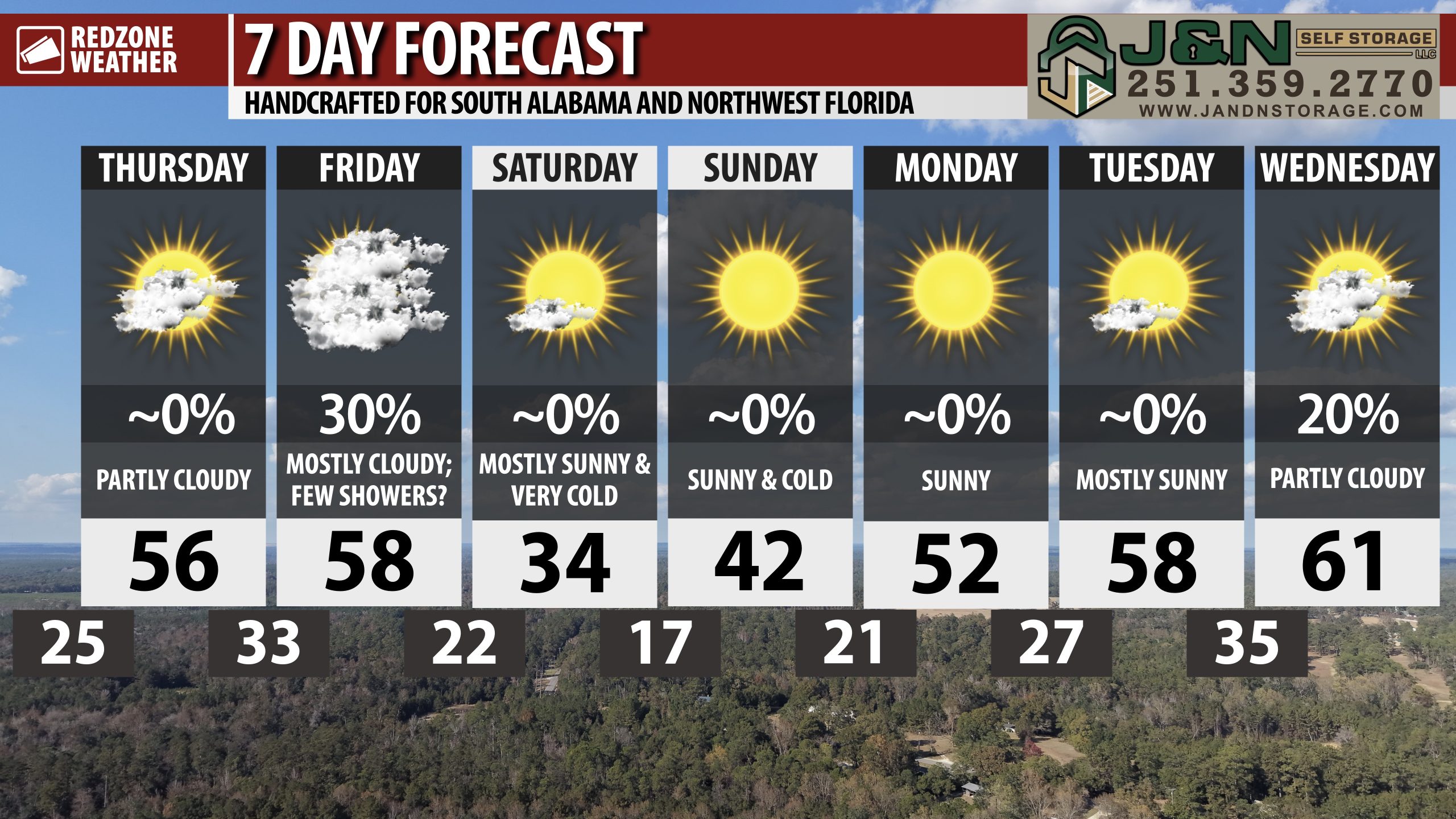
RAIN SHOWERS POSSIBLE AT TIMES TOMORROW… A few rain showers will be possible across south Alabama and northwest Florida tomorrow (Friday) ahead of very cold, dry air surging into the region tomorrow night into Saturday morning.
HIGHS on Saturday will struggle to get to the freezing mark in some communities. VERY cold weekend ahead!

PARTLY CLOUDY THURSDAY; FEW RAIN SHOWERS FRIDAY… Skies will be partly cloudy on this Thursday with afternoon highs in the mid to upper 50s. We will have somewhat of a break from the Arctic deep freeze tonight. Some communities closer to the coast will remain above the freezing mark tonight. Tomorrow, isolated showers will become possible as an area of low pressure develops and moves across our area to the east. All of the showers will be in the form of rain as temperatures will be far too mild locally for any wintry precipitation. Very cold air moves in tomorrow night, long after the rain is gone. High temperatures on Saturday will struggle to get above the freezing mark. Cold temperatures persist into Sunday and Monday.
ISOLATED SHOWERS LOCALLY TOMORROW; FLURRIES WELL TO OUR NORTH… An area of low pressure that ultimately will become a powerful Nor’easter system on Sunday into Monday will move across our region on Friday. This feature will pave the way for a few widely scattered rain showers at times. Rain chances remain in the 20-30% chance range across the region. There is a good chance most communities remain completely dry tomorrow. Afternoon high temperatures on Friday will be in the upper 50s and perhaps even low 60s in some spots.
VERY COLD THIS WEEKEND… Very cold, dry air moves into south Alabama and northwest Florida on Friday night into early Saturday morning. Temperatures will be below freezing Saturday morning with wind chill values in the upper 10s. Afternoon HIGHS will struggle to get back to 32° on Saturday. Temperatures will be in the upper 10s and low 20s on Saturday night into Sunday morning. Wind chill values will likely be in the single digit range in many communities locally on Sunday morning.
DRY WEATHER SATURDAY, SUNDAY, INTO EARLY NEXT WEEK… Saturday, Sunday, Monday, and Tuesday will likely be dry, cold days. Highs on Sunday will be around the 40° mark with highs in the 50s on both Monday and Tuesday. No rain or precipitation is expected in that range.
EARLY SIGNS OF A WARMUP IN 8-10 DAYS… While it is impossible to be specific at this stage, consistent data across the major global weather models points to somewhat of a warmup expected to happen around February 8. That doesn’t mean it will be warm, far from it most likely, but we probably will have more seasonal temperatures with high temperatures in the 60s and lows in the upper 30s and 40s. The consistent shots of Arctic cold air may come to somewhat of a halt at that point.
APP… If you haven’t already downloaded the RedZone Weather app, now is a great time to do that. redzoneweather.com/app is the link to the free download. Once you have the RZW app installed on your iOS or Android device, be sure to visit the Alerts tab to turn on the specific notifications you’d like to receive. All notifications are handcrafted by me. No automation and we promise not to bug you!
See all the details in your Thursday RedZone Weather forecast video. My next forecast video will be posted by 7:15AM tomorrow morning. I will have updates posted throughout the day, as needed, in the RedZone Weather app.
I hope you have a great Thursday!

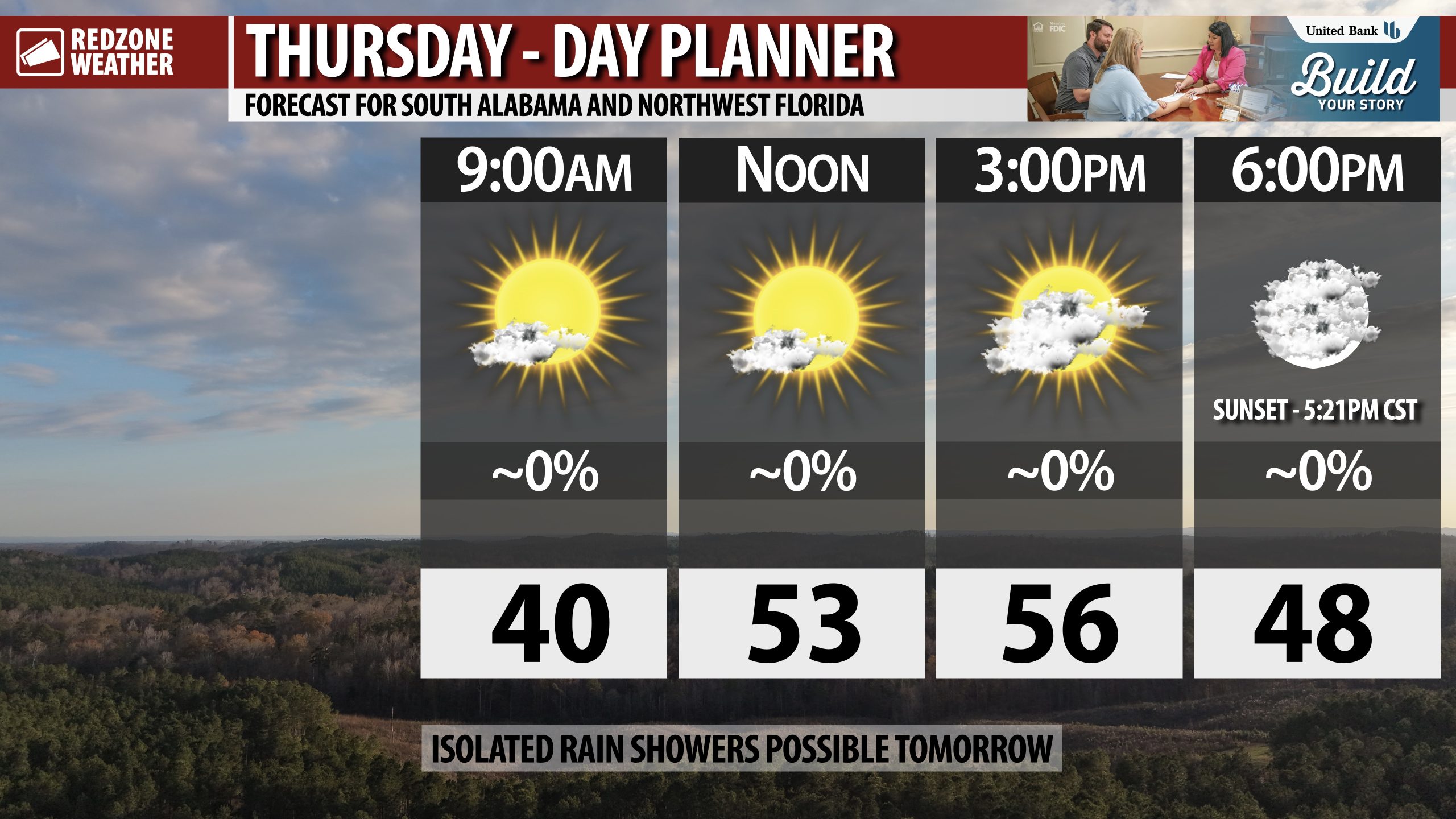
PARTLY CLOUDY THIS AFTERNOON… Increasing cloudiness will happen this afternoon into this evening ahead of a chance of a few widely scattered rain showers locally on Friday.
Afternoon highs today will be in the mid 50s.
Have a great Thursday!

Weather model animation of dew point — showing the extremely dry (and cold) Arctic air spilling into the Southeast and then down the Florida peninsula on Sunday.
The northeast Gulf relative warm waters save Tampa and Miami from a hard freeze like Orlando in the low-20s. pic.twitter.com/S9dWi6mnZ3
— Ryan Maue (@RyanMaue) January 29, 2026
