
11:55PM September 28, 2026
RT @AllEmeraldCoast: I was running errands in Orange Beach tonight, and as I was about to get on the bridge heading home, I saw what was pr…
— Spinks Megginson (@rzweather) September 29, 2026

RT @AllEmeraldCoast: I was running errands in Orange Beach tonight, and as I was about to get on the bridge heading home, I saw what was pr…
— Spinks Megginson (@rzweather) September 29, 2026
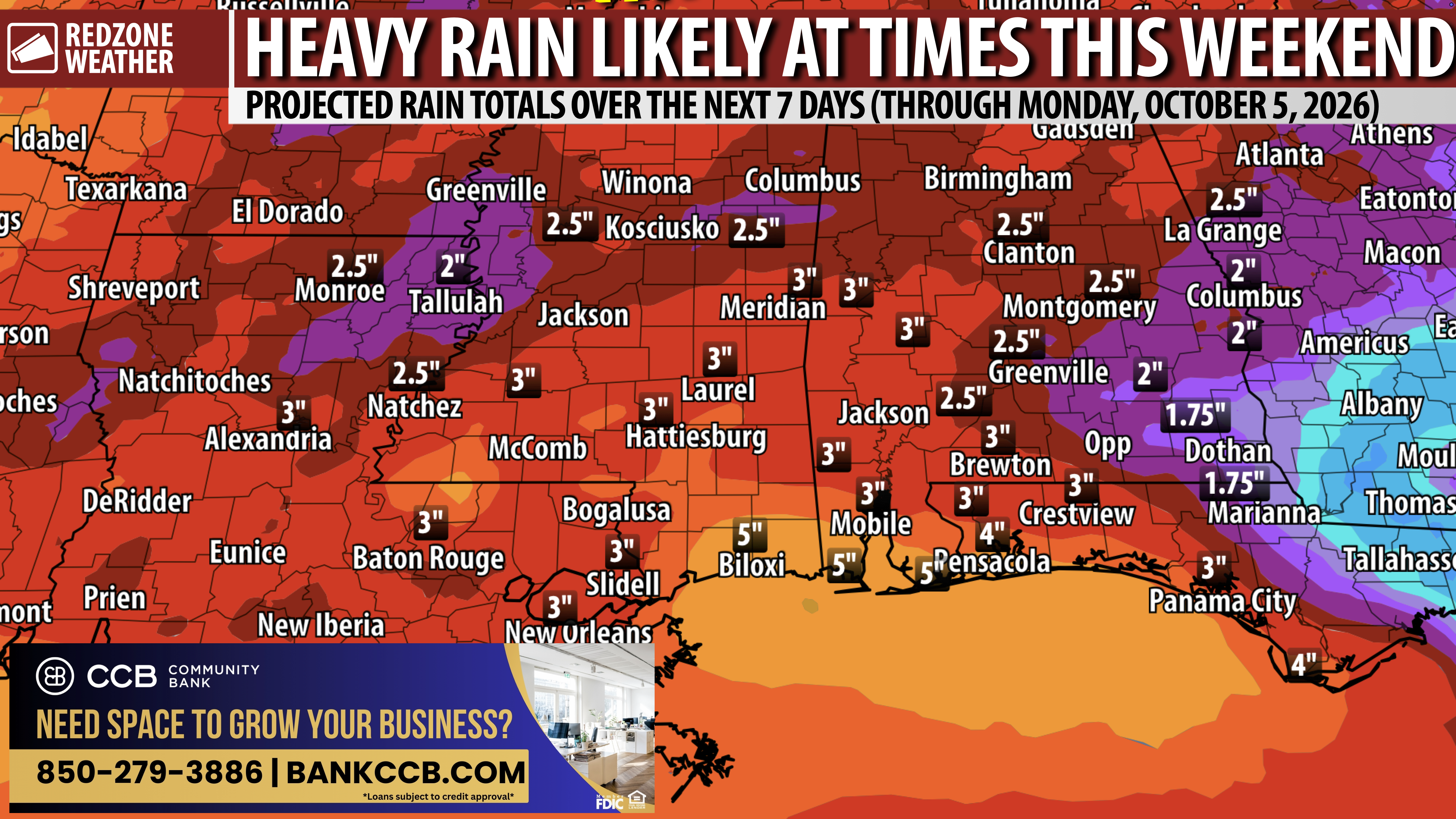
ACTIVE WEATHER AHEAD THIS WEEKEND; MULTIPLE WAVES OF RAIN & STORMS… Quiet weather will continue through midweek ahead of an increasingly active weather pattern set to happen across the Deep South this weekend into early next week. I am expecting multiple rounds of rain and thunderstorms starting as early as Friday. Saturday and Sunday will likely be quite wet throughout each day with multiple rounds of rain and storms being possible. There is a chance we may have to deal with at least some risk of a few stronger storms, but confidence in hazard placement and intensity remains low, for now. This is something I will be closely monitoring in the days ahead. Please join me for the daily morning video updates for more info.
PROLIFIC GULF MOISTURE TO LEAD TO SCATTERED TO NUMEROUS STORMS THIS WEEKEND… While there will be breaks in the rain this weekend, I expect multiple waves of rain and storms on Saturday and Sunday. The high school football games on Friday may be wet at times. Flash flooding may be a concern this weekend if storms train over the same areas.
APP… If you’re not already using the RedZone Weather app, you can download it for free at redzoneweather.com/app. I post brief weather updates in the app throughout the day, as needed. Be sure to visit the Alerts tab after downloading the app so you can select the specific notifications you’d like to receive.
I will have a detailed look at the forecast in the next regularly scheduled RedZone Weather forecast video that will be posted by 7:15AM.
Have a nice Monday evening!

ACTIVE WEATHER AHEAD THIS WEEKEND; MULTIPLE WAVES OF RAIN & STORMS… Quiet weather will continue through midweek ahead of an increasingly active weather pattern set to happen across the Deep South this weekend into early next week. I am expecting multiple rounds of rain and https://t.co/q5RjxMcn4A
— Spinks Megginson (@rzweather) September 29, 2026

RT @crimsonscholar: Sunset from Daphne @rzweather @sp https://t.co/jp7mDoopEc
— Spinks Megginson (@rzweather) September 29, 2026

Beautiful sunset at Fort Morgan, AL this evening. Thanks to Becky Riggs for the view! @NWSMobile https://t.co/pDrNFgek2B
— Spinks Megginson (@rzweather) September 28, 2026

RT @britttg_94: A little cloudy, but a nice evening in Atmore. ⛅️
@NWSMobile @spann @AlabamaWXNet @rzweather @KNBHwx @ThomasGeboyWX @WKRG…
— Spinks Megginson (@rzweather) September 28, 2026

Hurricane Polo is on the cusp of making landfall in the Baja Peninsula of Mexico. The storm will likely make landfall as a category 3, major hurricane this evening or tonight. Remnant moisture from Polo will bring heavy rain to the Great Plains in the days ahead. https://t.co/K4dFypA2Bt
— Spinks Megginson (@rzweather) September 28, 2026
