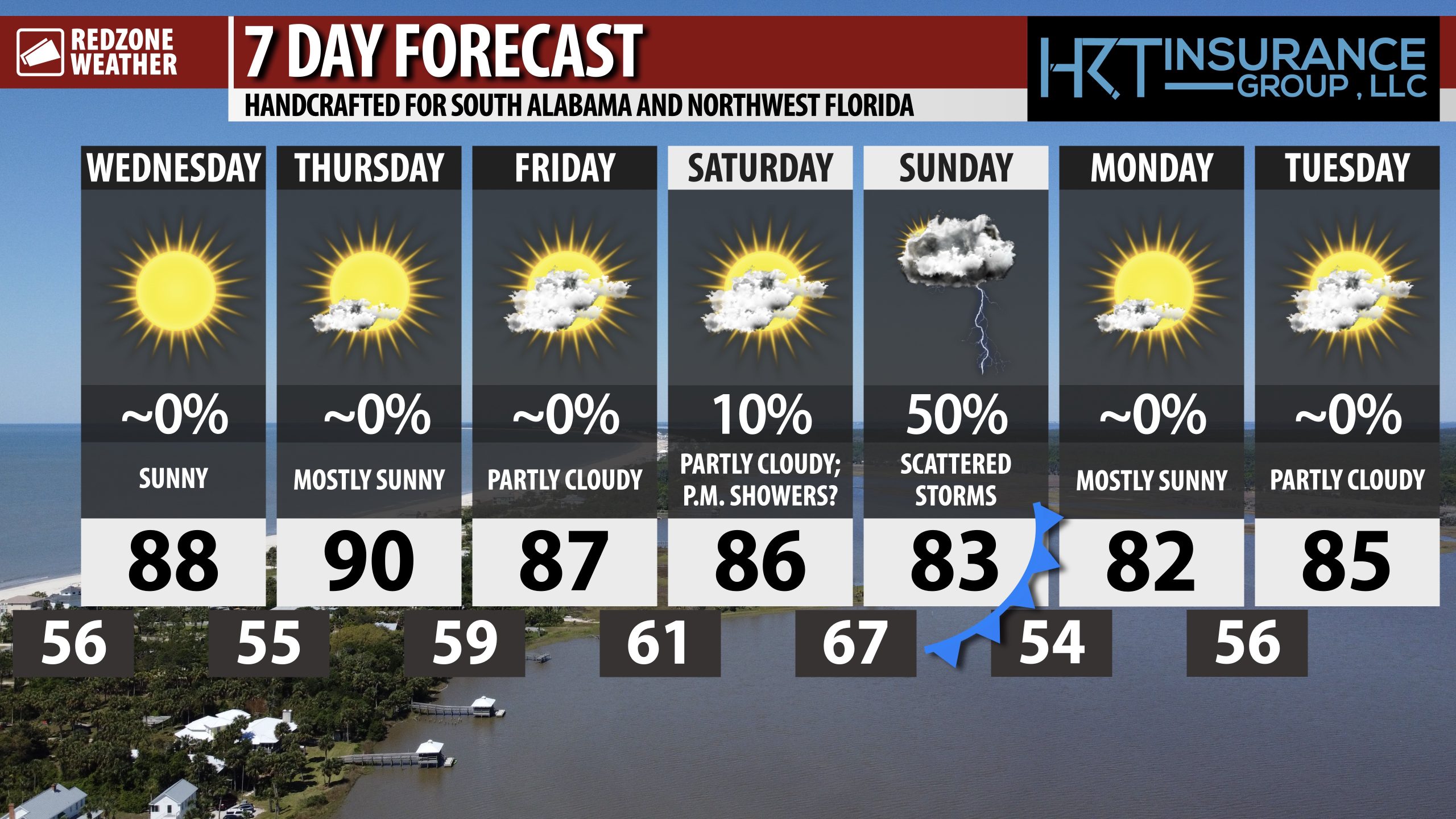
SUNNY, NICE WEDNESDAY; SCATTERED STORMS POSSIBLE SUNDAY… High temperatures will be in the upper 80s this afternoon with a full supply of sunshine expected throughout the day across south Alabama and northwest Florida on this Wednesday. Thursday and Friday will be dry days locally ahead of our next rain chance setting up late Saturday night into Sunday as a cold front approaches from the northwest. For now, the overall threat of any severe storms locally remains low, however, a few strong to severe storms may be possible during the daytime hours of Saturday to our northwest.
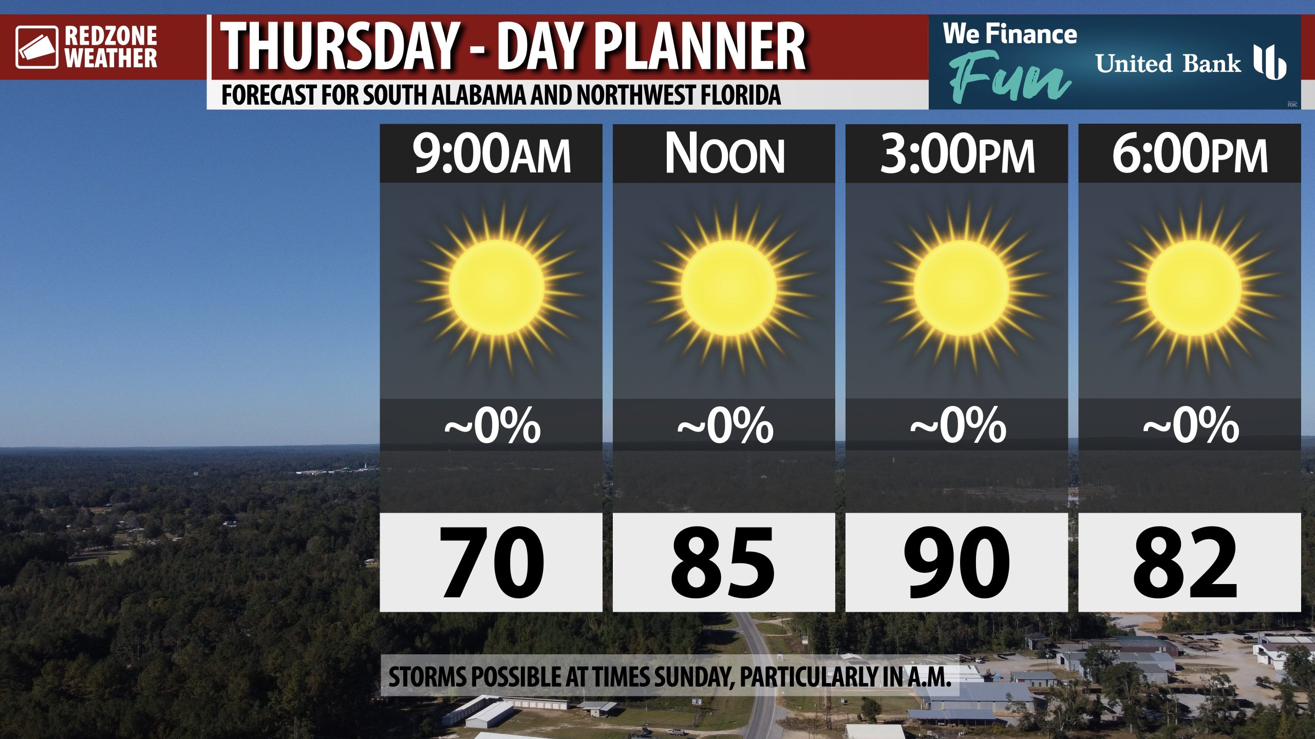
WARM DAYS, COOL NIGHTS THROUGH SATURDAY… Cool temperatures with overnight lows in the mid to upper 50s are expected on Thursday and Friday mornings. Afternoon highs today, tomorrow, and Friday will be in the mid to upper 80s. Some communities may briefly hit the 90 degree mark each afternoon through Saturday.
STRONG TO SEVERE STORMS POSSIBLE TO OUR NORTHWEST ON SATURDAY… The Storm Prediction Center has added a Level 2 (out of 5) severe weather risk for all of Arkansas valid for Saturday into Saturday night. In addition, parts of eastern Oklahoma, northeast Texas, northern Louisiana, northwest Mississippi, western parts of Tennessee and Kentucky, southern Illinois, eastern Oklahoma, and much of the southern half of Missouri are also involved in this Level 2 (out of 5) severe weather risk. Damaging wind gusts, large hail, and a few tornadoes will be possible in these zones on Saturday into Saturday night.
SCATTERED STORMS POSSIBLE LOCALLY SUNDAY… The same cold front responsible for the severe weather risk to our northwest on Saturday moves our way on Saturday night into Sunday. For now, the overall parameters do not look particularly supportive for a significant severe weather setup locally, but a few strong to severe storms may be possible. I suspect the Storm Prediction Center will add a Level 1 (out of 5) low-end severe weather risk for our local area on Sunday to account for this possibility. Unfortunately, not every community across the local area will have rain with this event as storms will be scattered in nature.
NICER WEATHER INTO EARLY NEXT WEEK… Monday and Tuesday of the upcoming week will be partly cloudy with high temperatures in the low 80s. Overnight lows will be in the 50s early next week.
TROPICS: LORENZO STRUGGLING IN CENTRAL ATLANTIC… Tropical Storm Lorenzo, centered about 1,400 miles west of the Cabo Verde Islands in the central Atlantic Ocean, continues to be a weak, rather disorganized system. Lorenzo will remain well away from land areas over the next few days as the system drifts north in the open waters of the Atlantic.
TROPICS: GULF & CARIBBEAN QUIET… The Gulf and Caribbean remain quiet with no new tropical storms expected to develop over the next 5-7 days. The 2025 Atlantic Hurricane Season will end on Sunday, November 30.
APP… If you haven’t already downloaded the RedZone Weather app, now is a great time to do that. redzoneweather.com/app is the link to the free download. Once you have the RZW app installed on your iOS or Android device, be sure to visit the Alerts tab to turn on the specific notifications you’d like to receive. All notifications are handcrafted by me. No automation and we promise not to bug you!
See all the details in your Wednesday morning RedZone Weather forecast video. My next forecast video will be posted by 7:15AM Thursday morning. I will have updates posted throughout the day, as needed, in the RedZone Weather app.
Have a great Wednesday!