7:13PM October 3, 2025
From N Crestview. pic.twitter.com/HXdqlr5WC0
— VegasAnnieinFL (@VegasAnnieinFL) October 4, 2025

From N Crestview. pic.twitter.com/HXdqlr5WC0
— VegasAnnieinFL (@VegasAnnieinFL) October 4, 2025
Sunset Atmore,AL @spann @NWSMobile @rzweather @ThomasGeboyWX @AlanSealls @WKRGEd @TaylorWVTM13 @AlabamaWXNet @thisisalabama @textamet @KDanielCCI @StormHour @CloudAppSoc #alwx #sunset pic.twitter.com/jMQFkq6x9n
— Ditto Gorme (@dittogorme) October 3, 2025

What a gorgeous homecoming sunset in Brewton tonight@rzweather @spann pic.twitter.com/3mSFL71FnP
— AUBURN SUPERFAN #2✈️ (@MichaelFloyd_AU) October 3, 2025
The tropical disturbance near The Bahamas is no more organized today compared to yesterday. 10% chance of this system briefly becoming a tropical storm – probably won’t happen.
50% chance of a tropical wave developing into a tropical storm in the Atlantic in the days ahead. pic.twitter.com/xGfQQV86Fx
— Spinks Megginson (@rzweather) October 3, 2025

Scattered storms are likely on Sunday, mainly in the P.M. hours. There is a chance some communities will remain dry further inland on Sunday, but generally speaking, the closer you are to the coast, the higher your rain chances will be.
Low-end rain chances today and tomorrow,… pic.twitter.com/XkSa0E7xP4
— Spinks Megginson (@rzweather) October 3, 2025

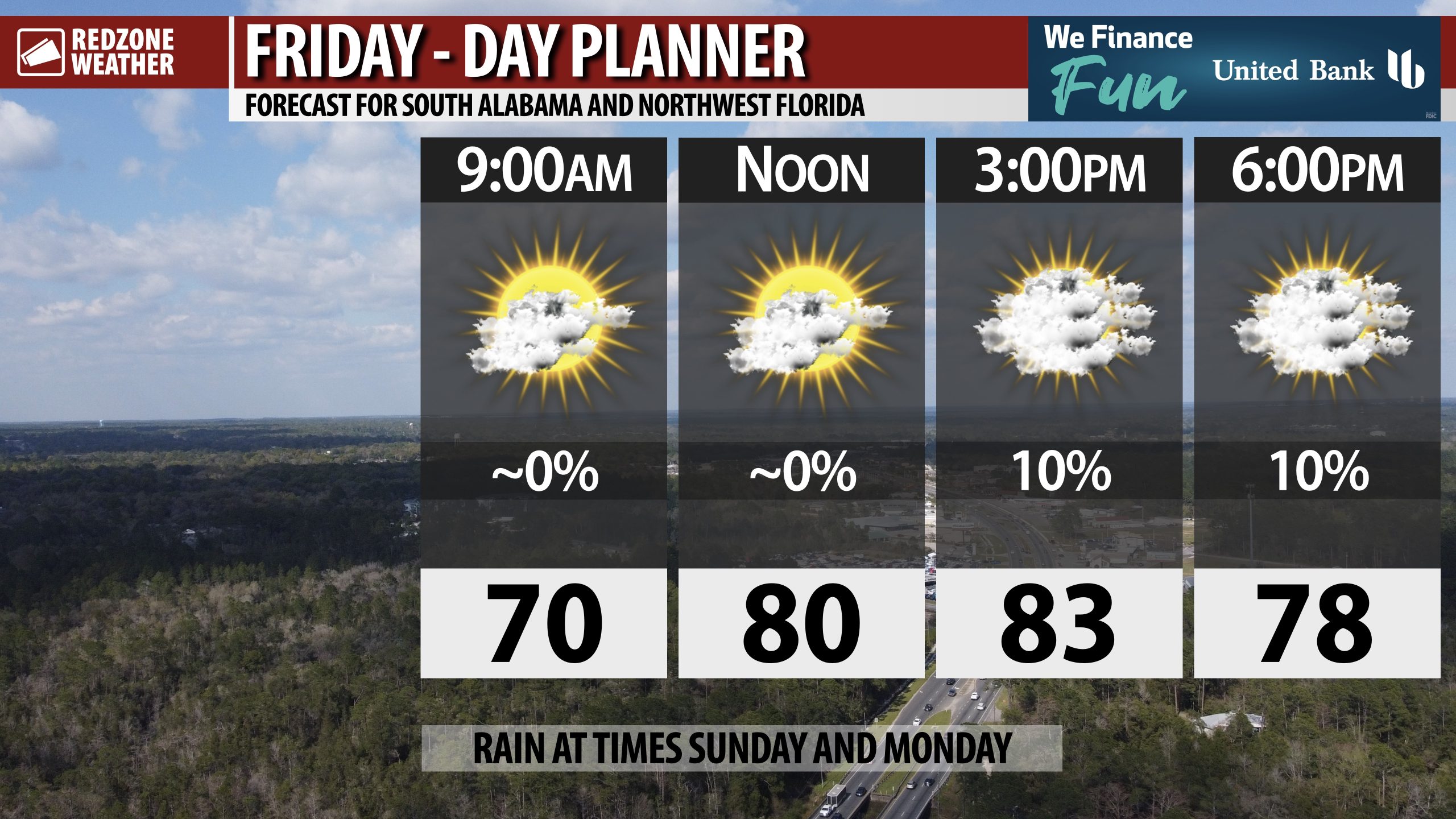
FEW SHOWERS POSSIBLE NEAR COAST TODAY… Isolated showers will become possible this afternoon, particularly near the Alabama and Northwest Florida beaches. Most locations across the region will remain dry.
High temperatures will be in the low 80s.
MOST of the high school football games across the region tonight will be dry, but a few may have showers around, specifically those games happening closer to the coast.
Hope you have a great weekend!

Moonlight in Mobile, Alabama@NWSMobile @spann @WKRGEd @JasonSmithWX @rzweather @grantskinner_wx @StormHour #ALwx pic.twitter.com/1mF6zRwPzb
— Stephen Simpson 🇺🇦 ProperGander (@BamaStephen) October 3, 2025
