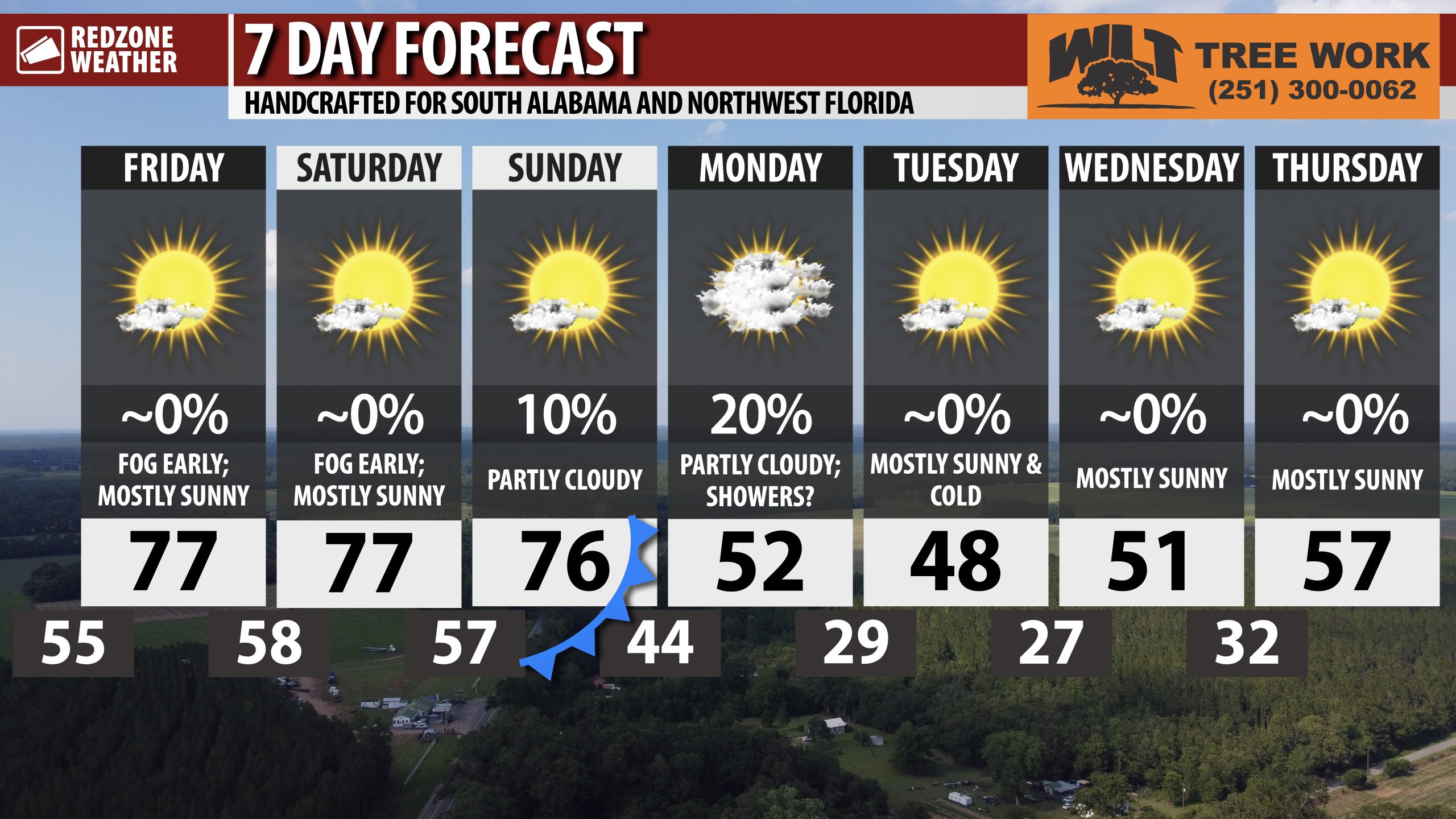
BEAUTIFUL, MILD FRIDAY; FOGGY NIGHTS & MORNINGS; COLD START TO NEXT WEEK… It is quite foggy across much of south Alabama and northwest Florida on this Friday. Dense fog will continue to be a concern over the next few hours and again tonight into Saturday morning. Please take it slow if you’ll be driving in the foggy conditions. Fog will burn off between 9-11AM today, lingering longer in the communities near the beaches and bays. Mostly sunny skies are likely this afternoon into this evening. Afternoon high temperatures will be in the mid to upper 70s.
MILD WEEKEND; FOG CONCERNS PERSIST… Foggy nights and mornings are expected tonight and again tomorrow night, lingering into the morning hours on Saturday and on Sunday. Mostly sunny afternoons are in store for the weekend with afternoon highs expected to be in the mid to upper 70s.
RAIN POSSIBLE MONDAY AHEAD OF MUCH COLDER TEMPERATURES EARLY NEXT WEEK… Showers will be possible on Monday with afternoon highs in the mid 60s. Not every community across the region will have rain, but scattered showers will be possible ahead of an advancing cold front. No snow or mixed precipitation is expected. Thankfully, at this point, no severe weather issues are expected either.
MUCH COLDER TUESDAY… Monday night into Tuesday morning will have overnight lows in the 20s. Freeze precautions will be needed across the region. Afternoon highs on Tuesday will be in the 40s with clearing skies.
APP… If you haven’t already downloaded the RedZone Weather app, now is a great time to do that. redzoneweather.com/app is the link to the free download. Once you have the RZW app installed on your iOS or Android device, be sure to visit the Alerts tab to turn on the specific notifications you’d like to receive. All notifications are handcrafted by me. No automation and we promise not to bug you!
See all the details in your Friday morning RedZone Weather forecast video. My next forecast video will be posted by 7:15AM Monday morning. I will have updates posted throughout the weekend, as needed, in the RedZone Weather app.
Hope you have a great weekend!