6:17PM January 14, 2026
Spotty rain showers are drifting east across the region this evening.
We will dry out completely after 10PM. pic.twitter.com/kmNdxcJhLv
— Spinks Megginson (@rzweather) January 15, 2026

Spotty rain showers are drifting east across the region this evening.
We will dry out completely after 10PM. pic.twitter.com/kmNdxcJhLv
— Spinks Megginson (@rzweather) January 15, 2026
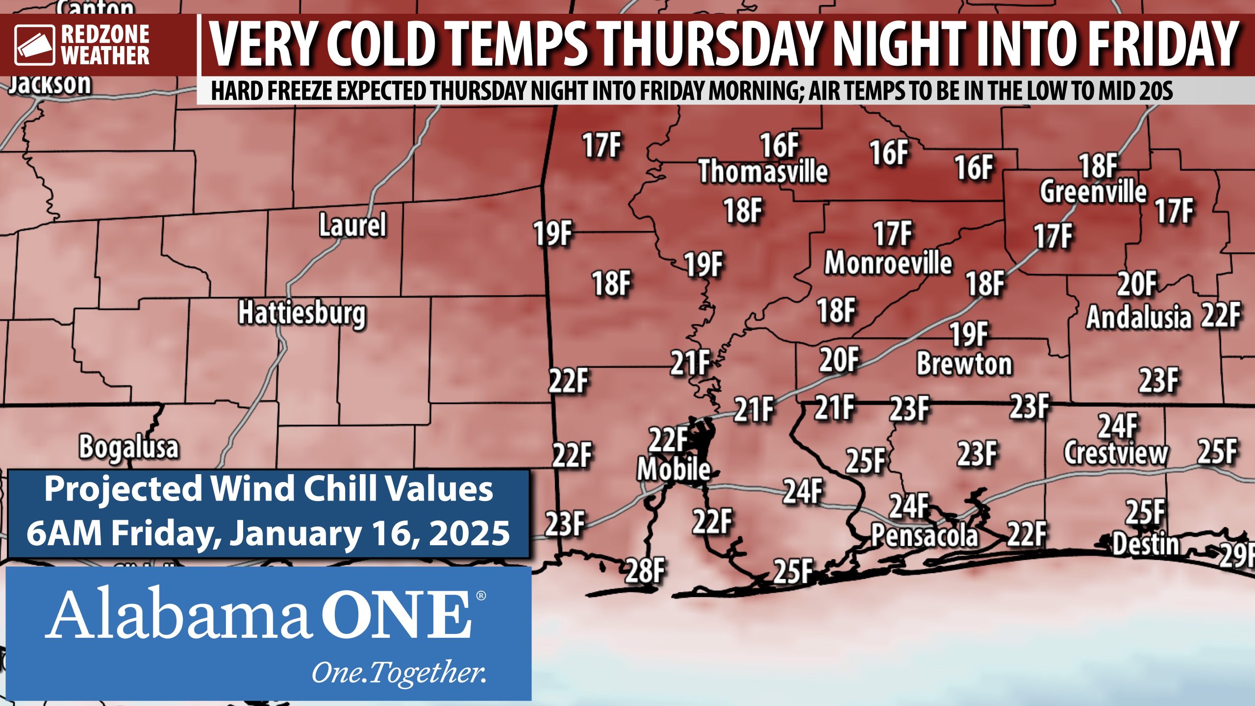
HARD FREEZE THURSDAY NIGHT; TEMPS TO BE BELOW FREEZING FOR NEARLY 12 HOURS… I am in the process of writing up a detailed report on the wintry precipitation/snow potential coming Saturday night into Sunday. I will have that posted by 9PM. Before we get there, you need to be aware we have a hard freeze coming up tomorrow night. The numbers depicted on this map are the forecast wind chill values valid at 6AM on Friday morning.
High temperatures tomorrow (Thursday) will only be in the 40s across the entire region. We rapidly fall below freezing tomorrow evening around 8-9PM. Most communities will remain at or below 32° until 8-9AM Friday morning. Definitely a night we all will need to have freeze precautions in place! Outdoor pets should be inside along with any sensitive plants.
I am writing up detailed info about the “s-word” (snow!) that everyone has been talking about today. This is definitely going to be a lot different than our big snow event last January. It looks like this precipitation may come through early Sunday morning before sunrise. Details coming around 9PM. Be sure to join me then for the latest.
Have a good Wednesday evening

Looking west from Pensacola International Airport. @rzweather pic.twitter.com/jm9OIOVIwu
— Asa Schlobohm (@SchlobohmAsa) January 14, 2026

Freezing temperatures return to the area tonight, pic.twitter.com/wdt7FWBONO
— NWS Mobile (@NWSMobile) January 14, 2026

PRECIP CHANCES THIS WEEKEND… After trending drier for the last few days, this morning’s guidance has trended much wetter. Yet another humbling reminder: Snow is, BY FAR, the most difficult thing to forecast in the Deep South.
When something is rare and there aren’t a lot of analogs for models to look at, it makes forecasting a whole lot tougher.
I’ll be watching trends today. Detailed update will be posted around 9PM. Check with me then for latest info.
I am headed to Flomaton Elementary for a weather presentation this afternoon. Have a good Wednesday afternoon!

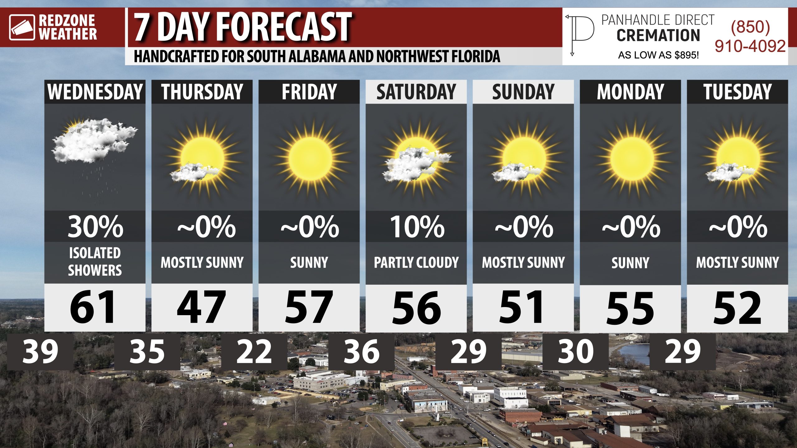
COLD DAYS UPCOMING… After rain clears out later today, we’re headed into what may be the coldest week of the year (potentially). There is a high chance we don’t see 60 degrees for about a week.
Overnight lows will be below freezing Thursday night and again on Saturday, Sunday, and Monday nights!

Spotty sprinkles and showers continue to drift east across parts of southwest Alabama this morning.
At 8:17AM, showers are happening near Old Texas, Forest Home, Starlington, Peterman, Gosport, and Deer Park. pic.twitter.com/Fh3nM5r7t7
— Spinks Megginson (@rzweather) January 14, 2026
