5:33PM November 2, 2025
A stunning November sunset this evening here in Orange Beach. pic.twitter.com/ls7Cf4DUrH
— City of Orange Beach (@cityorangebeach) November 2, 2025

A stunning November sunset this evening here in Orange Beach. pic.twitter.com/ls7Cf4DUrH
— City of Orange Beach (@cityorangebeach) November 2, 2025
As we enter November, landfalling U.S. hurricanes become rare. Since 1851, only 5 have ever made landfall, most recently NICOLE 2022.
UNNAMED 1899 was the strongest, making landfall in South Carolina with winds of 95 kts (110 mph). Interestingly, November has featured more U.S.… pic.twitter.com/eKo7O4laDU
— Michael Ferragamo (@FerragamoWx) November 2, 2025

Frost Advisory for Clarke, Choctaw, Wilcox, Marengo, Dallas counties and points north in west Alabama.
Temperatures as low as 34 degrees possible overnight into early Monday morning. 🥶
This includes Thomasville, Grove Hill, Fulton, Jackson, Camden, Sweet Water, Gilbertown, and… pic.twitter.com/UrIKnXrsFG
— Spinks Megginson (@rzweather) November 2, 2025

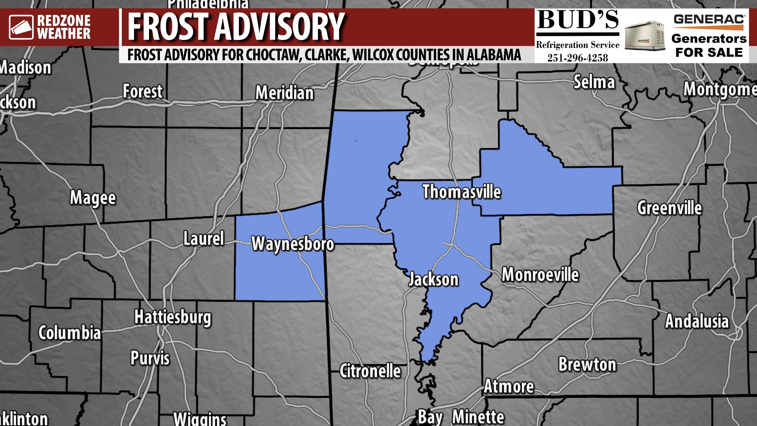
FROST ADVISORY OVERNIGHT FOR PARTS OF WEST ALABAMA… A Frost Advisory has been issued for Clarke, Wilcox, and Choctaw counties in west Alabama along with Wayne County in SE Mississippi.
This is in effect from 1AM to 8AM Monday.
Temperatures as low as 34° may result in frost formation.
This includes Thomasville, Grove Hill, Jackson, Fulton, Whatley, Coffeeville, Gilbertown, Needham, Butler, Toxey, Camden, Pine Hill, Oak Hill, and surrounding areas.

SUNNY MONDAY; MILD DAYS, COOL NIGHTS UPCOMING… Sunny, nice weather is expected today and tomorrow across south Alabama and northwest Florida. High temperatures will be upper 60s today. Tonight will be chilly, just like last night. Most locales will dip into the upper 30s inland with temperatures near 40° across a big chunk of the local area. Clear skies are expected overnight. Plenty of sunshine is likely on Tuesday, Wednesday, and Thursday, ahead of our next potential chance of rain on Friday and Saturday.
WARMER TEMPERATURES LATER THIS WEEK… High temperatures will progressively climb into the mid 70s by Wednesday with temperatures near the 80 degree mark by Friday afternoon. Overnight lows will also be increasing each morning to the upper 40s by Thursday morning.
NEXT CHANCE OF RAIN MAY HAPPEN FRIDAY INTO SATURDAY… A frontal boundary slated to cross our region from northwest to southeast will approach on Friday. This feature may cause just enough lift to spark off a few showers and perhaps a few thunderstorms near the coast. I will be closely monitoring model trends over the next several days to see if we see an uptick in rain chances. For now, we’ll call it only a 10% chance of rain on both Friday and Saturday.
TROPICS ARE QUIET… The Gulf, Caribbean, and entire Atlantic Basin are expected to remain quiet this week. I am not expecting any new tropical storms to develop over the next 5-7 days. There is a growing probability we may have had the final named tropical system of the year, although it certainly wouldn’t be completely unprecedented to have a named storm in November. For now, the global models are not suggesting any significant development over the next 7-10 days in the Atlantic Basin. The 2025 Atlantic Hurricane Season will end on Sunday, November 30.
APP… If you haven’t already downloaded the RedZone Weather app, now is a great time to do that. redzoneweather.com/app is the link to the free download. Once you have the RZW app installed on your iOS or Android device, be sure to visit the Alerts tab to turn on the specific notifications you’d like to receive. All notifications are handcrafted by me. No automation and we promise not to bug you!
See all the details in your Monday morning RedZone Weather forecast video. My next forecast video will be posted by 7:15AM tomorrow morning. I will have updates posted throughout the day, as needed, in the RedZone Weather app.
Hope you have a great start to your week!

Clouds happening along, south, & east of Interstate 65 today will continue to clear to the east ahead of drier air pushing in from the west.
Many communities will dip into the upper 30s and low 40s tonight. A Frost Advisory has been issued for inland stretches of south Alabama. pic.twitter.com/DzO2eAUdBL
— Spinks Megginson (@rzweather) November 2, 2025

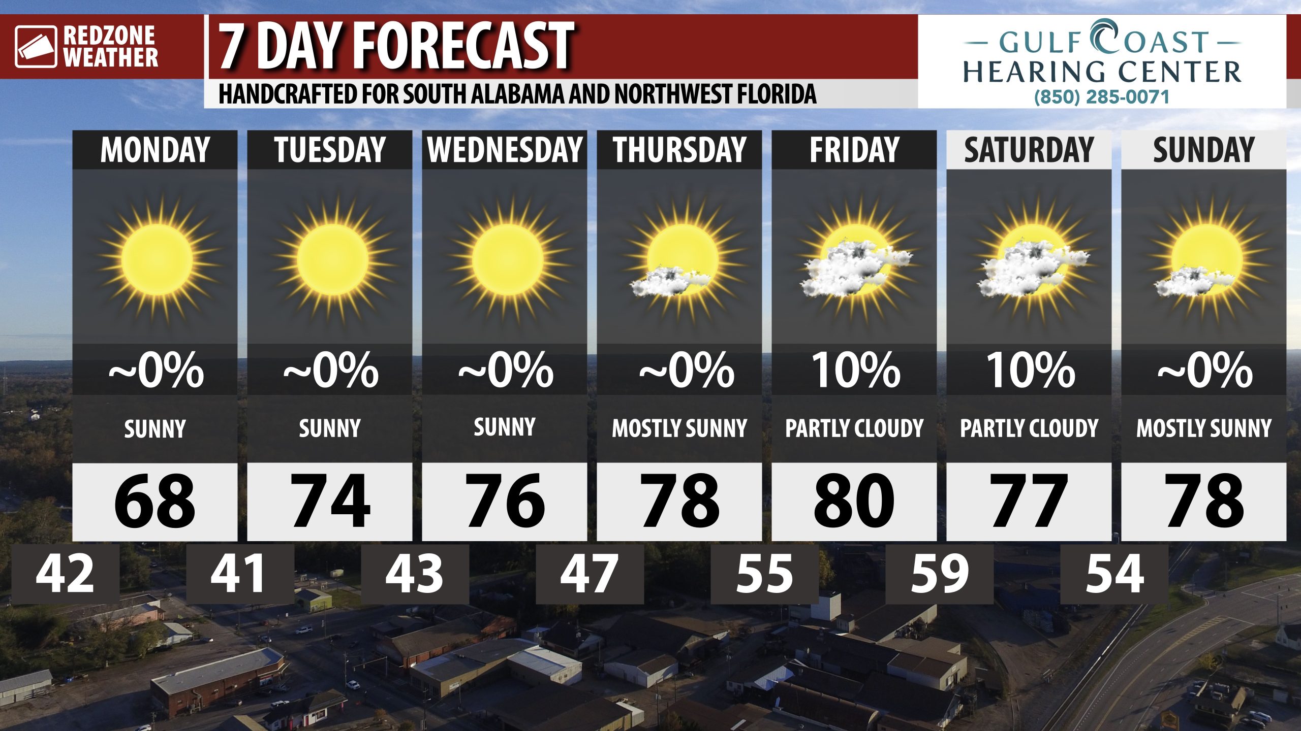
SUNNY, NICE WEATHER OVER NEXT FEW DAYS… Next chance of rain happens Friday into Saturday, but it’s questionable just how much rain will happen as a frontal boundary approaches from the northwest. For now, we’ll go with low-end rain chances. Greater chances to our north.
Plenty of sunshine today and tomorrow!
