8:07AM September 5, 2025
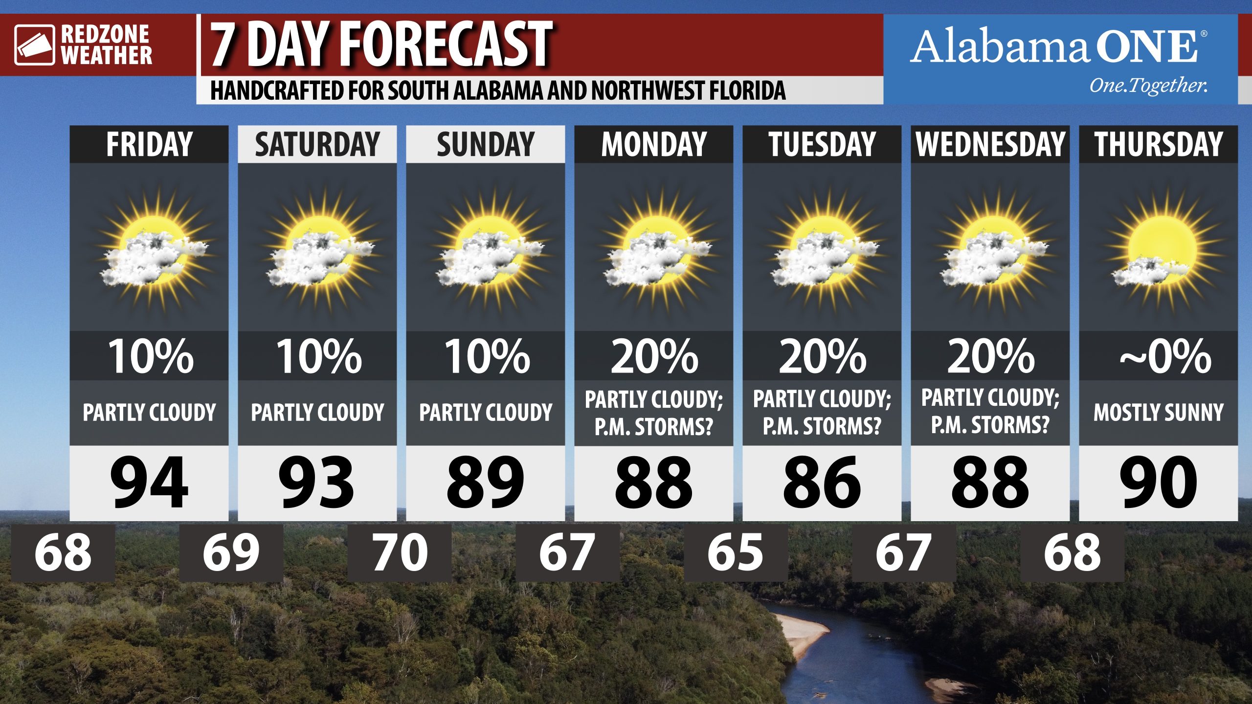
PARTLY CLOUDY DAYS COMING UP… No big rain event in sight. Hot temperatures persist today and tomorrow ahead of SLIGHTLY cooler temperatures early next week.

PARTLY CLOUDY DAYS COMING UP… No big rain event in sight. Hot temperatures persist today and tomorrow ahead of SLIGHTLY cooler temperatures early next week.
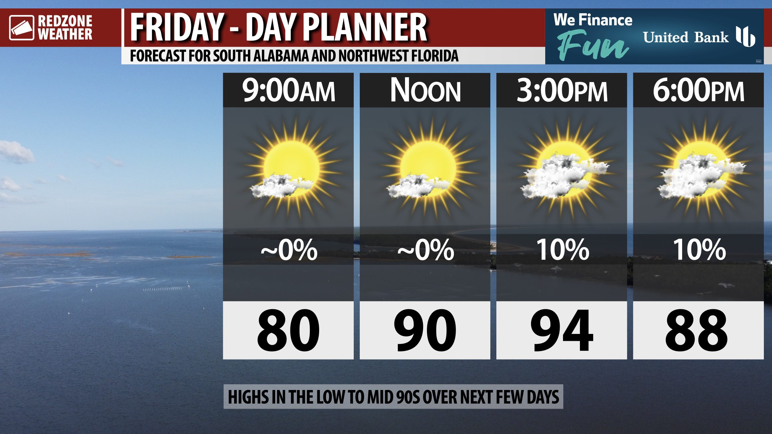
HOT TEMPS TODAY AND TOMORROW; LOW-END RAIN CHANCES THRU WEEKEND… Afternoon highs will be in the mid 90s in many communities across the region on this Friday. While nearly all of us across the region will remain dry, a few widely scattered showers and thunderstorms can’t be ruled out, specifically this evening. Hot temperatures, increasing humidity, and a few P.M. storms are likely on Saturday and Sunday as well. Fortunately as we approach the climatological peak of hurricane season in just a few days, we have no imminent local tropical issues in the Gulf.
HIGH SCHOOL FOOTBALL FORECAST – TONIGHT… Most of the high school football games across south Alabama and northwest Florida should remain dry this evening. There is a low-end (10%) chance of a few widely scattered showers and thunderstorms this evening between 4PM and 9PM. Any storms that develop probably won’t last long in any one spot. Temperatures around 6-7PM will be in the mid to upper 80s. By 9PM, temperatures will be near 80° with upper 70s possible.
LOW-END RAIN CHANCES ON SATURDAY AND SUNDAY… Plenty of sunshine is expected on both Saturday and Sunday with high temperatures in the upper 80s and near the 90 degree mark. Low-end (10%) rain chances will persist this weekend with any storms likely developing between 3PM and 10PM. Most communities across the local area will remain dry all weekend long.
TROPICS: GULF & CARIBBEAN REMAIN QUIET… The Gulf and Caribbean Sea remain quiet with no new tropical storms expected to form over the weekend and into early next week. The climatological peak of hurricane season happens on September 11. That doesn’t mean the Gulf will become active around the peak, necessarily, but it does mean we have to watch any systems that have any potential of developing carefully. For now, the Gulf remains quiet.
TROPICS: 90% CHANCE OF TROPICAL STORM DEVELOPING IN ATLANTIC… There is a very high chance we will have a named tropical storm develop over the weekend or early next week. The National Hurricane Center has the probability now at a 90% chance. From NHC: “A broad area of low pressure has formed along a tropical wave over the eastern tropical Atlantic. Recent satellite imagery suggests the system continues to slowly become better organized with shower and thunderstorm activity along its eastern periphery. Environmental conditions are favorable for additional development of the system and a tropical depression is likely to form by this weekend as it moves slowly westward at 5 to 10 mph across the eastern and central tropical Atlantic. Interests in the Lesser Antilles and Leeward Islands should monitor the progress of this system as it approaches from the east by the middle of next week.” The next name for a tropical storm in the Atlantic Basin would be Gabrielle.
See all the details in your Friday morning RedZone Weather forecast video. My next forecast video will be posted by 7:15AM Monday morning. I will have updates posted throughout the day, as needed, in the RedZone Weather app.
Have a great weekend!

HOTTER TEMPS THIS AFTERNOON… Building heat is expected today with high temperatures expected to be in the mid 90s. A few widely scattered showers & thunderstorms are not completely out of the question this afternoon into this evening.
High school football across the region should be dry for the most part.

Expect dry and warm conditions tonight with lows dipping into the upper 60's and lower 70's inland with middle 70's nearer the coast. pic.twitter.com/XJiCcFhXXk
— NWS Mobile (@NWSMobile) September 4, 2025

If you look closely on radar, you can see three isolated showers this evening located near Seminole, Holt, and Deerland.
Most spots will remain dry over the next several hours but a few widely scattered showers and storms will be possible. pic.twitter.com/9YDGieTgWm
— Spinks Megginson (@rzweather) September 4, 2025

90% chance of a tropical storm developing in the central Atlantic Ocean over the next several days as a tropical wave moves west.
Next name: Gabrielle.
Too early to know if this will be a direct problem for the U.S. pic.twitter.com/2WZBefo7S9
— Spinks Megginson (@rzweather) September 4, 2025

Scattered severe storms are in progress at midday across parts of East Tennessee and western North Carolina.
Locally in south Alabama and northwest Florida, just a few passing cumulus clouds for now. Isolated storms possible over the next several hours. pic.twitter.com/BhgNCQWTcw
— Spinks Megginson (@rzweather) September 4, 2025
