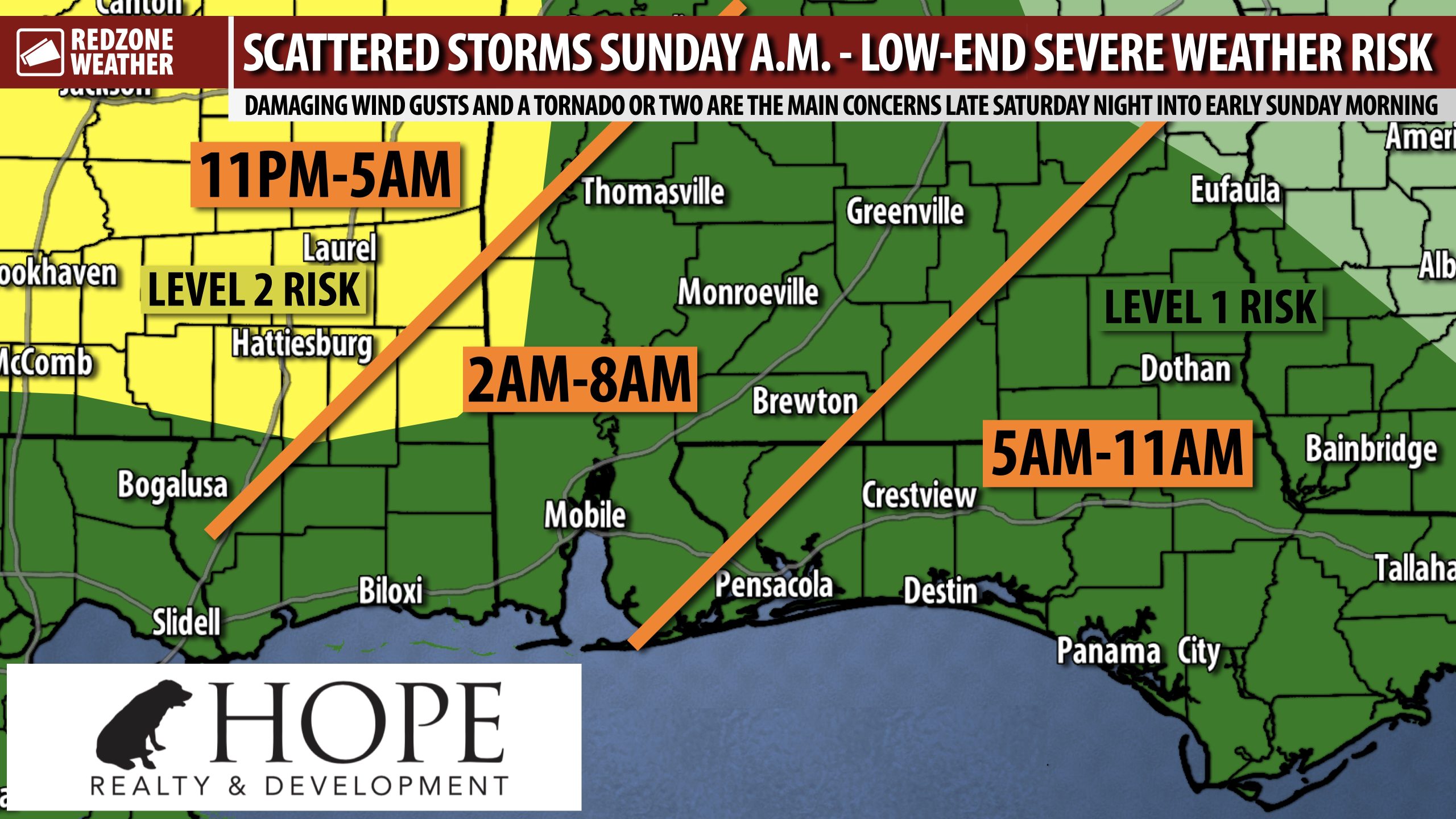
RAIN & STORMS TONIGHT INTO SUNDAY MORNING; A FEW STRONG TO SEVERE STORMS POSSIBLE… Scattered thunderstorms are likely at times overnight into Sunday morning, some of which may be strong or marginally severe. All of us across south Alabama and northwest Florida are now included in the Level 1 (out of 5) low-end severe weather risk valid tonight into Sunday morning. This means that MOST of us will probably just have rain and thunder at times. A few strong to severe storms capable of producing damaging wind gusts and a tornado or two may become possible. The overall risk of severe storms is a bit higher across the far western part of Alabama near the AL/MS state line and into Mississippi. These are the zones now involved in the Level 2 (out of 5) severe weather risk.
SEVERE WEATHER TIMING – TONIGHT INTO SUNDAY MORNING… 11PM tonight to 11AM Sunday morning continues to be the 12 hour window for strong to severe thunderstorms to happen across south Alabama and northwest Florida with the core window being from 3AM to 9AM. Most communities across south Alabama and northwest Florida will simply have occasional rain and thunder at times but a few, brief severe storms may become possible overnight tonight into Sunday morning. We encourage everyone to have multiple ways to hear urgent weather warnings just in case a warning becomes required for your specific location.
LINE OF STORMS APPROACHES FROM WEST; A FEW CELLS AHEAD OF LINE POSSIBLE… The main issues overnight into Sunday will probably be from the main line of thunderstorms (a QLCS/squall line) that moves generally from northwest to southeast across the local area. Damaging wind gusts and a tornado or two will be possible if this line of storms holds its intensity while moving across our local area. In addition, some of the higher-res model guidance is hinting at the potential for a few discrete, isolated thunderstorms out ahead of the main line. If this scenario happens and discrete cells form ahead of the line, the tornado risk would increase. Have a way to hear warnings overnight into Sunday.
BENEFICIAL RAIN EXPECTED… Drought conditions across south Alabama and northwest Florida continue to worsen each day due to a significant lack of rainfall. This rain/storm event tonight into Sunday should help to at least put a dent into drought conditions with MOST communities across the region now projected to pick up between 0.5″ and 1.5″ of rainfall in total through Sunday.
COOLER TEMPS COMING SUNDAY NIGHT… A cold front approaching the local area is the forcing mechanism responsible for this low-end severe weather risk tonight into Sunday morning. This cold front will move through Sunday afternoon behind the advancing line of storms. Cooler, drier weather will happen on Sunday night, Monday, into Tuesday. Overnight lows by Monday morning will likely be in the upper 40s in many communities across the region. Highs on Monday will top out in the upper 70s.
TORNADO WARNING POLICY… Any time there is an active tornado warning in effect for southwest Alabama or northwest Florida, we provide uninterrupted, live video coverage on Facebook Live and in the RedZone Weather app. Our detailed coverage commitment is outlined at redzoneweather.com/coverage. We are proud to cover all parts of Escambia (AL), Covington, Monroe, Conecuh, Baldwin, Mobile, Clarke, Washington, Butler, Escambia (FL), Santa Rosa, and Okaloosa counties. If you live in any locale in those counties, be sure to tune into our coverage whenever there is an active tornado warning!
APP ALERTS… redzoneweather.com/app is the link where you can download the free RedZone Weather app. We post brief updates throughout each day in the app, keeping you up-to-date about the latest happenings in weather across south Alabama and northwest Florida. Once you have the free app downloaded to your iOS or Android device, be sure to visit the Alerts tab (lower right corner) then tap the large Alert Settings button to customize the alerts you would like to receive straight from me.
I will have updates posted throughout the day and into tonight, as needed, in the RedZone Weather app. Have a great Saturday!
