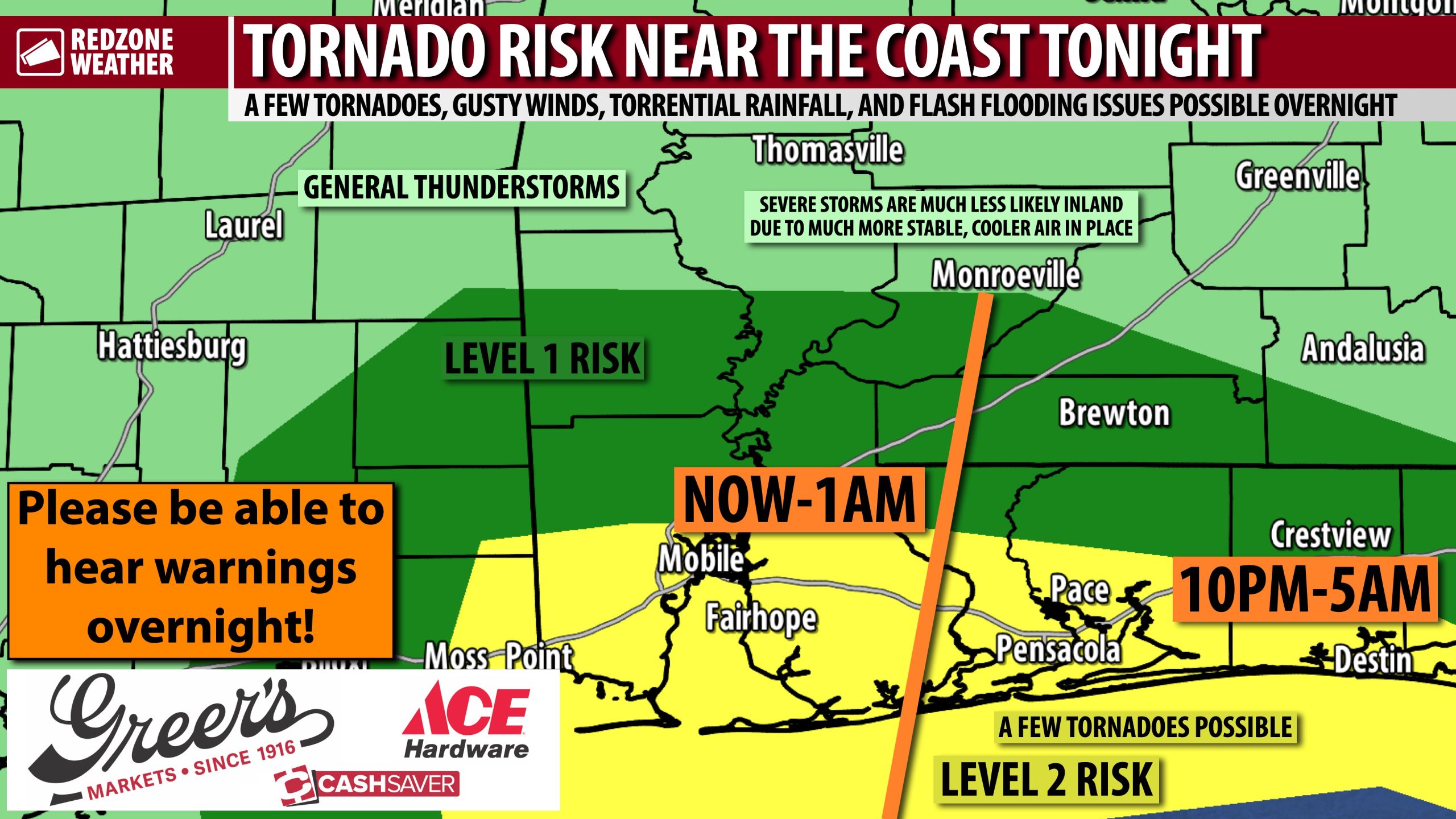
ROUND OF STORMS DEVELOPING NEAR COAST MAY CAUSE A FEW TORNADOES OVERNIGHT… Unfortunately, the expected Round 2 (of 2) of the strong to severe thunderstorms is materializing this evening across Mobile Bay, the Mississippi Sound, and the northern Gulf near Dauphin Island and Ft. Morgan. These storms will expand in size and very slowly translate to the east over the next several hours. The Storm Prediction Center now has a Level 2 (out of 5) tornado risk in place for much of Mobile, Baldwin, Escambia (FL), Santa Rosa, Okaloosa, and Walton counties, specifically the southern parts of these counties closer to the coast. These are the zones where the air mass in place is a bit more unstable and may support a few tornadoes in addition to very heavy rainfall. Everyone should have multiple ways to hear warnings before you go to sleep tonight, just in case a tornado warning is needed for your specific location!
SEVERE WEATHER TIMING – OVERNIGHT… There was some thought earlier that the first round of storms that happened this morning and this afternoon may stabilize the atmosphere to the point that this second round of storms doesn’t fire up. Unfortunately, the atmosphere has destabilized to the point that we are now seeing strong storms develop near Mobile Bay. The progression to the east will be slow, plain and simple, although we may see some new storms develop in the northern Gulf that push onshore in Northwest Florida before these storms arrive. The severe weather risk will be most pronounced for Mobile and Baldwin counties over the next few hours until 1AM. The risk will ramp up across northwest Florida after 10PM and extend into the overnight hours. Please have something that can wake you up (like a NOAA Weather Radio) in case your specific location goes under a tornado warning overnight.
FLASH FLOOD CONCERNS… Parts of southern Baldwin (AL) and southern Escambia (FL) counties had extreme rain amounts earlier today. Several rain gauges near Orange Beach, specifically, ended up with 8+ inches of total rainfall just this morning. This means that flash flooding may happen quickly across coastal areas and become quite significant in a hurry. These storms will be efficient and prolific rain producers overnight for areas near the coast. It cannot be stressed enough, if you encounter a water-covered roadway, please “turn around, don’t drown.” We lose way too many folks across America each year to this totally preventable cause of death.
FEW LINGERING SHOWERS ON MONDAY DURING THE DAY… I expect most of the daytime hours of Monday to be dry with a few lingering showers being possible in the morning and early afternoon hours. High temperatures tomorrow will be in the low 70s.
TORNADO WARNING POLICY… Any time there is an active tornado warning in effect for southwest Alabama or northwest Florida, we provide uninterrupted, live video coverage on Facebook Live and YouTube Live. Our detailed coverage commitment is outlined at redzoneweather.com/coverage. We are proud to cover all parts of Escambia (AL), Covington, Monroe, Conecuh, Baldwin, Mobile, Clarke, Washington, Butler, Escambia (FL), Santa Rosa, and Okaloosa counties. If you live in any locale in those counties, be sure to tune into our coverage whenever there is an active tornado warning!
APP ALERTS… redzoneweather.com/app is the link where you can download the free RedZone Weather app. We post brief updates throughout each day in the app, keeping you up-to-date about the latest happenings in weather across south Alabama and northwest Florida. Once you have the free app downloaded to your iOS or Android device, be sure to visit the Alerts tab (lower right corner) then tap the large Alert Settings button to customize the alerts you would like to receive straight from me.
I will have more updates posted throughout the evening and into tonight in the RedZone Weather app.
Have a great Sunday night!
