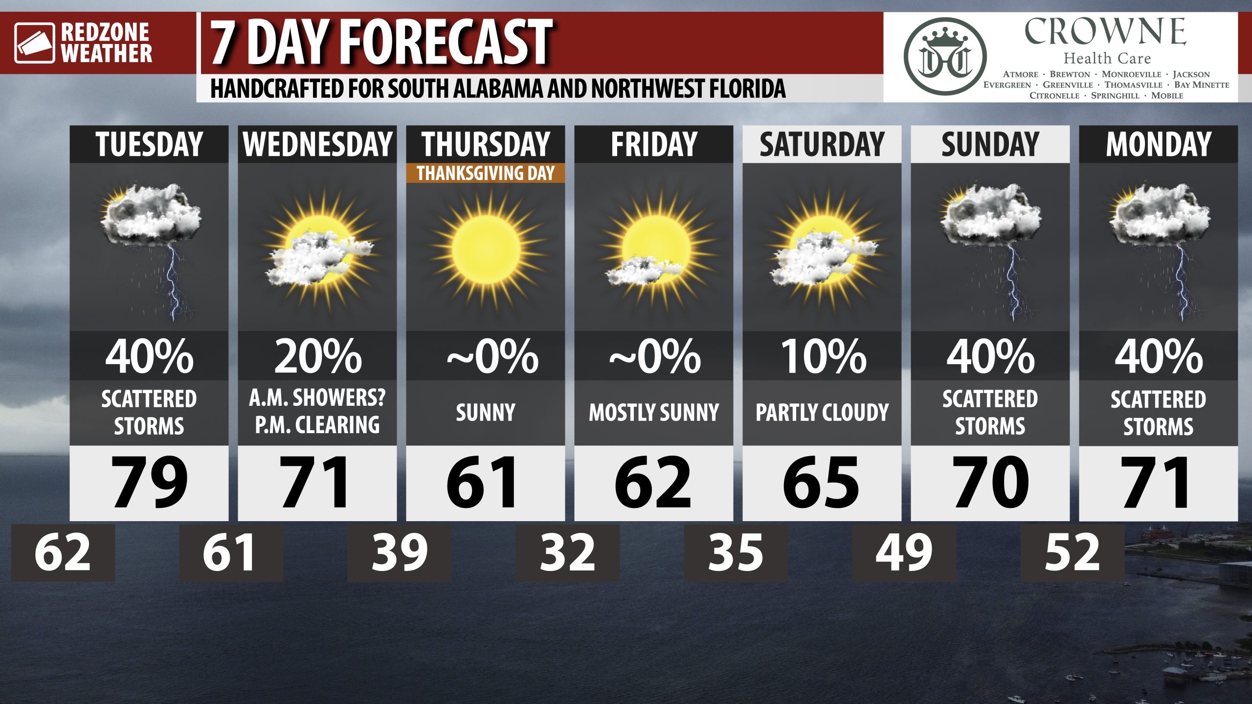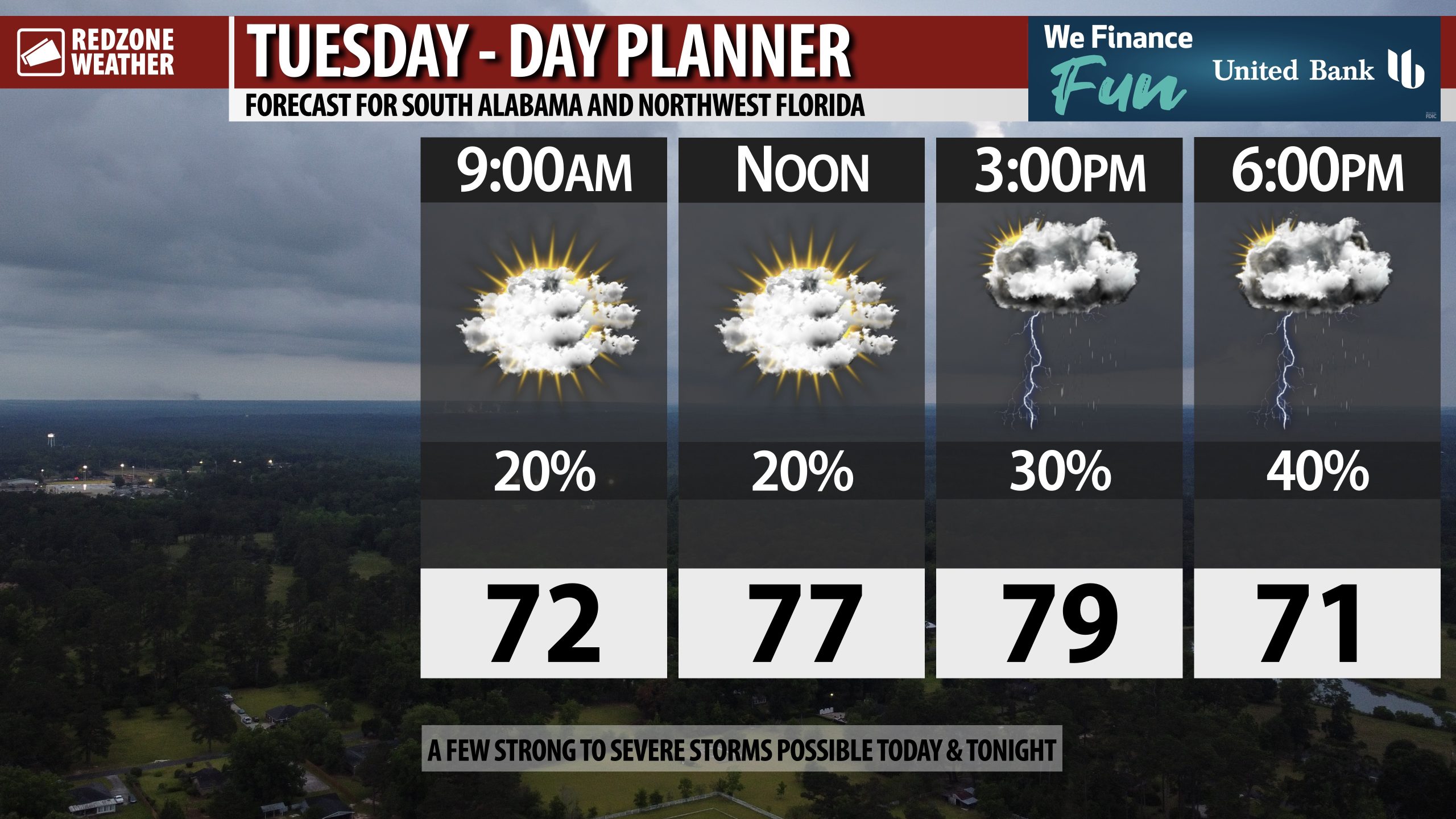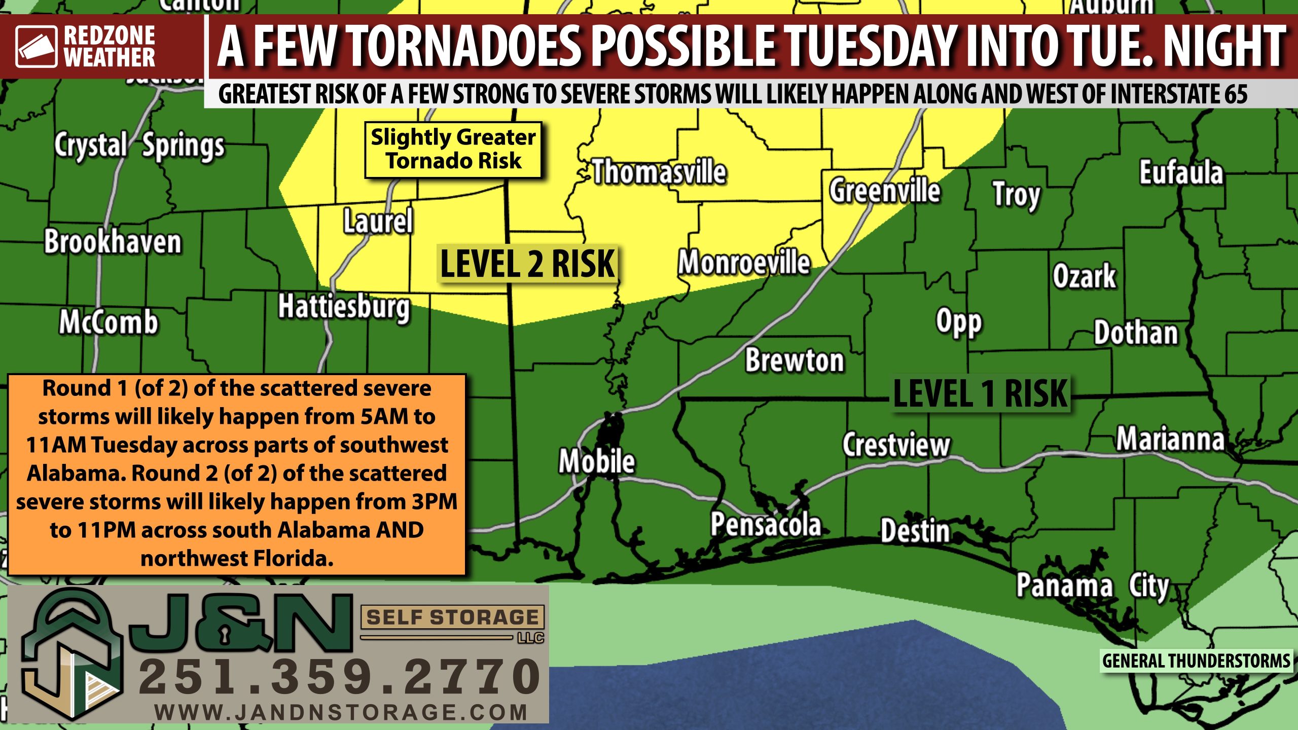
SCATTERED SEVERE STORMS POSSIBLE TUESDAY… Scattered strong to severe thunderstorms will be possible across Alabama, northwest Florida, and Mississippi on Tuesday into Tuesday night. The overall risk of a few tornadoes has increased, particularly across parts of central Alabama. The Storm Prediction Center has added a Level 2 (out of 5) severe weather risk zone for Tuesday into Tuesday night that includes places as far south as Chatom, Jackson, Monroeville, and Greenville. The remainder of the local area in south Alabama and northwest Florida remains involved in the low-end, Level 1 (out of 5) risk zone where severe storms still may be possible, but are less likely to happen. We probably will have multiple rounds of storms, one happening in the morning and the other round in the evening hours. We encourage everyone to have multiple ways to hear warnings tomorrow into tomorrow night, just in case your specific location goes under a tornado warning.
SEVERE WEATHER TIMING – TUESDAY… 5AM to 11AM Tuesday is when Round 1 of the storms will likely happen. The overall tornado risk will be maximized in this first round of storms due to plenty of atmospheric shear. Round 1 of the storms will probably happen in areas along and west (generally) of Interstate 65 in parts of southwest Alabama. Round 2 (of 2) happens between 3PM and 11PM across south Alabama and northwest Florida. Damaging wind gusts and large hail are the primary concerns in Round 2, although the tornado risk won’t drop to zero until the passage of the cold front late tomorrow night.
LEVEL 2 (OUT OF 5) SEVERE WEATHER RISK INLAND… The overall tornado risk will be maximized north of U.S. Highway 84 locally. A large chunk of Alabama and east Mississippi are now involved in the Level 2 (out of 5) severe weather risk on Tuesday into Tuesday night. This particular Level 2 risk is driven by the tornado potential. When a Level 2 risk is in place, that means scattered severe storms will be possible. Not every community will have severe weather issues – many probably won’t. The Level 2 (out of 5) risk includes Thomasville, Grove Hill, Jackson, Monroeville, Beatrice, Mexia, Lyeffion, Forest Home, Greenville, Chatom, Millry, Leroy, Gilbertown, Butler, Pennington, Sweet Water, Linden, Demopolis, Camden, Pine Hill, Oak Hill, Montgomery, Wetumpka, Prattville, Hayneville, Selma, Demopolis, Livingston, York, Greensboro, Eutaw, Centreville, Clanton, Hoover, Rockford, Alexander City, Roanoke, Sylacauga, Anniston, the entire Birmingham metro area, Tuscaloosa, Northport, and Aliceville.
LEVEL 1 (OUT OF 5) SEVERE WEATHER RISK FURTHER SOUTH AND EAST… The remainder of south Alabama and northwest Florida not included in the aforementioned Level 2 risk are involved in the lower-end, Level 1 (out of 5) risk zone. A Level 1 (out of 5) risk means that widespread, intense severe weather is not expected, but one or two strong to severe storms can’t completely be ruled out. This zone includes Mobile, Prichard, Saraland, Wilmer, Citronelle, Dauphin Island, Bayou La Batre, Daphne, Fairhope, Spanish Fort, Gulf Shores, Orange Beach, Foley, Summerdale, Robertsdale, Bay Minette, Stockton, Pensacola, Warrington, Walnut Hill, McDavid, Molino, Century, Bratt, Jay, Berrydale, Chumuckla, Milton, Pace, Gulf Breeze, Navarre, Allentown, Baker, Laurel Hill, Crestview, Eglin AFB, Fort Walton Beach, Niceville, Destin, Brewton, East Brewton, Atmore, Flomaton, Poarch, Huxford, Wallace, Appleton, Evergreen, Castleberry, Repton, Belleville, Uriah, Andalusia, Opp, Rose Hill, River Falls, Straughn, Florala, Luverne, Troy, Enterprise, Dothan, Eufaula, Auburn (AL), and Panama City.
COOLER WEATHER FOR THANKSGIVING DAY… Quieter (and cooler) weather arrives for Wednesday, Thanksgiving Day Thursday, and Friday ahead of a more active pattern returning this weekend into early next week. Some scenarios point to the potential for a few strong to severe storms being possible on Sunday into Monday, but it remains too early for specifics. Please check back with me later this week for more updates.
TORNADO WARNING POLICY… Any time there is an active tornado warning in effect for southwest Alabama or northwest Florida, we provide uninterrupted, live video coverage on Facebook Live and YouTube Live. Our detailed coverage commitment is outlined at redzoneweather.com/coverage. We are proud to cover all parts of Escambia (AL), Covington, Monroe, Conecuh, Baldwin, Mobile, Clarke, Washington, Butler, Escambia (FL), Santa Rosa, and Okaloosa counties. If you live in any locale in those counties, be sure to tune into our coverage whenever there is an active tornado warning!
APP ALERTS… redzoneweather.com/app is the link where you can download the free RedZone Weather app. We post brief updates throughout each day in the app, keeping you up-to-date about the latest happenings in weather across south Alabama and northwest Florida. Once you have the free app downloaded to your iOS or Android device, be sure to visit the Alerts tab (lower right corner) then tap the large Alert Settings button to customize the alerts you would like to receive straight from me.
I will have more updates posted throughout the evening in the RedZone Weather app.
Have a nice Monday evening!