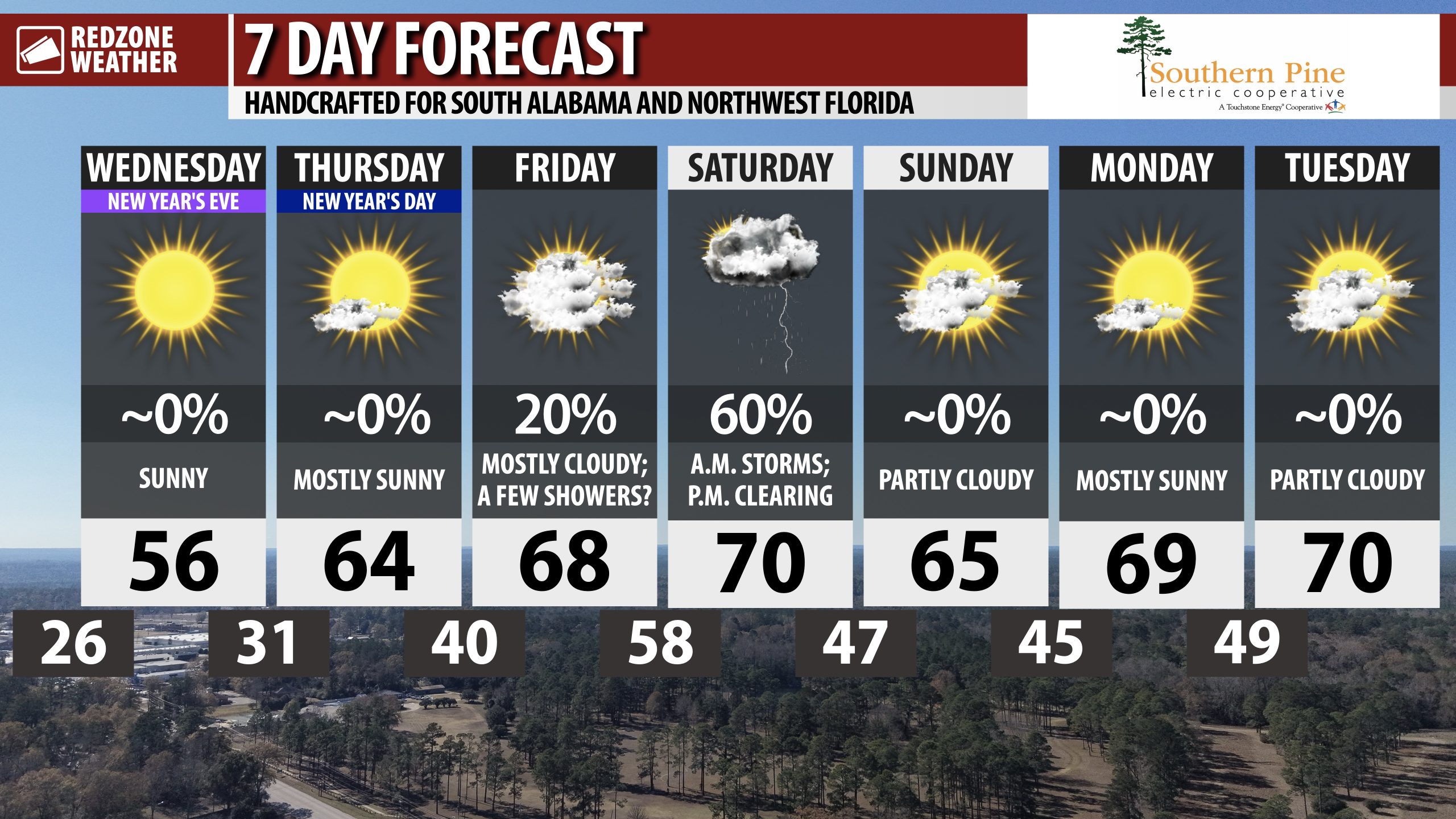
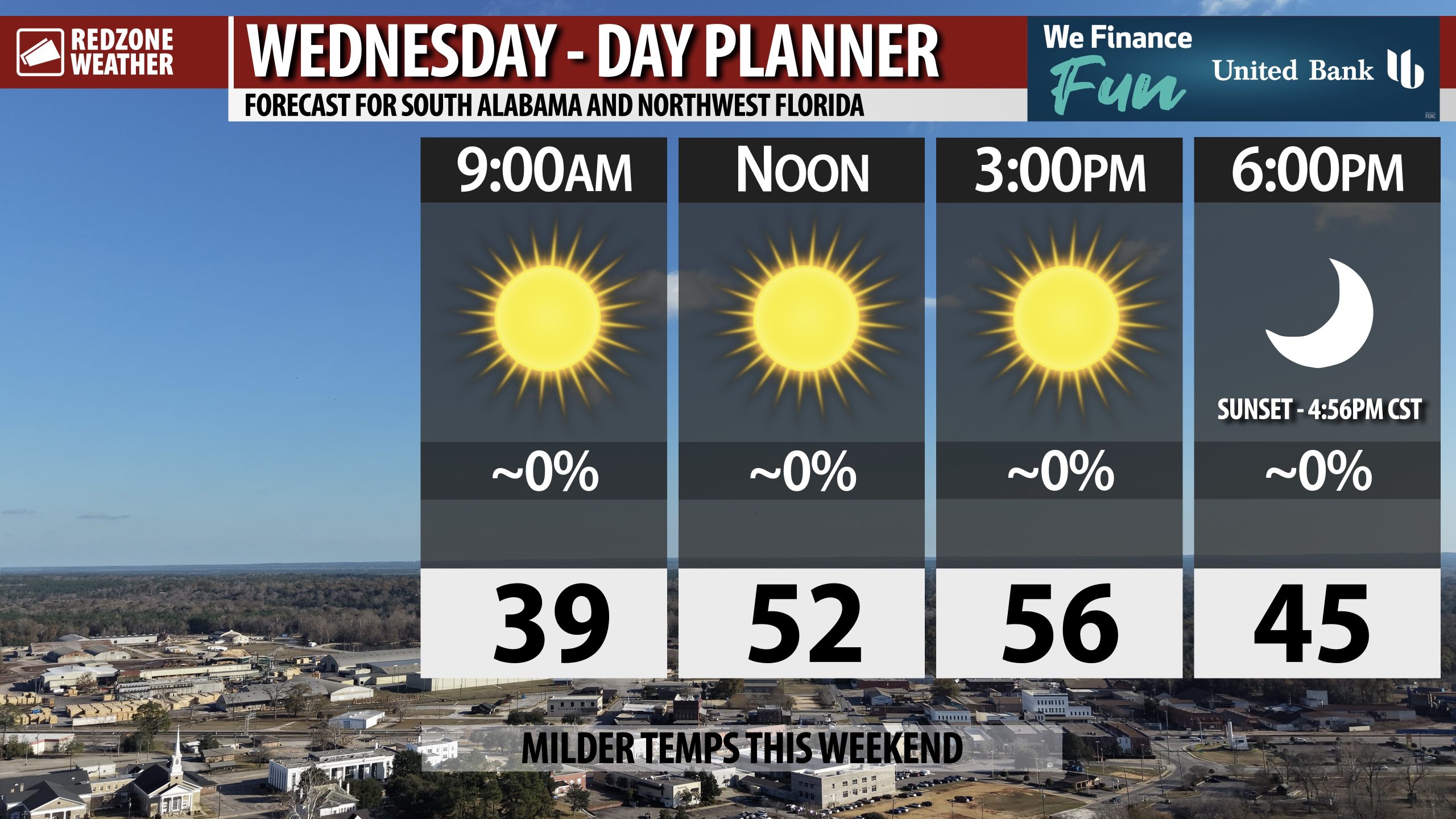
LAST DAY OF 2025 TO BE SUNNY; COLD TEMPS TO RING IN 2026 TONIGHT… The final day of 2025 will feature beautiful, sunny weather across south Alabama and northwest Florida. Plenty of sunshine is expected all day with afternoon high temperatures in the mid to upper 50s. Midnight festivities ringing in the New Year will be chilly with temperatures projected to be in the mid 30s around 12AM. We’ll be in the 30-32° range by daybreak tomorrow morning. Freezing temperatures will be long gone by the time our next rain chance arrives on Friday night into Saturday. Scattered thunderstorms may become possible Saturday morning with potentially a low-end risk of a few stronger storms.
MAINLY SUNNY FOR NEW YEAR’S DAY WITH SLIGHTLY MILDER TEMPS… New Year’s Day will bring mostly sunny skies with slightly milder temperatures. After a cold start, temperatures will reach the mid 60s by 2-3PM.
A FEW SHOWERS POSSIBLE FRIDAY… Cloud coverage will increase across the region on Friday. Isolated showers may become possible Friday morning ahead of our next significant chance of rain on Friday night into Saturday. High temperatures on Friday will be in the upper 60s.
SCATTERED STORMS POSSIBLE FRIDAY NIGHT INTO SATURDAY MORNING… Rain and thunderstorms will be possible Friday night into Saturday morning as an area of low pressure moves from west to east across the Deep South. There have been intermittent signals that some stronger storms may be involved, but it remains too early for specifics. This will likely end up being a low-end severe weather risk with gusty winds being the primary concern. Most communities will simply have rain and thunder at times. We dry out Saturday P.M. ahead of a streak of nice, mild days next week.
WARMER TEMPS NEXT WEEK… Temperatures will run above our climatological norms for this time of year in the afternoons as we get into the first full week of 2026. High temperatures will likely be near or just above the 70 degree mark Monday through Wednesday of the upcoming week. Overnight lows will likely be in the 40s.
APP… If you haven’t already downloaded the RedZone Weather app, now is a great time to do that. redzoneweather.com/app is the link to the free download. Once you have the RZW app installed on your iOS or Android device, be sure to visit the Alerts tab to turn on the specific notifications you’d like to receive. All notifications are handcrafted by me. No automation and we promise not to bug you!
See all the details in your Wednesday morning RedZone Weather forecast video. My next forecast video will be posted by 7:15AM tomorrow morning. I will have updates posted throughout the day, as needed, in the RedZone Weather app.
Have a great Wednesday!