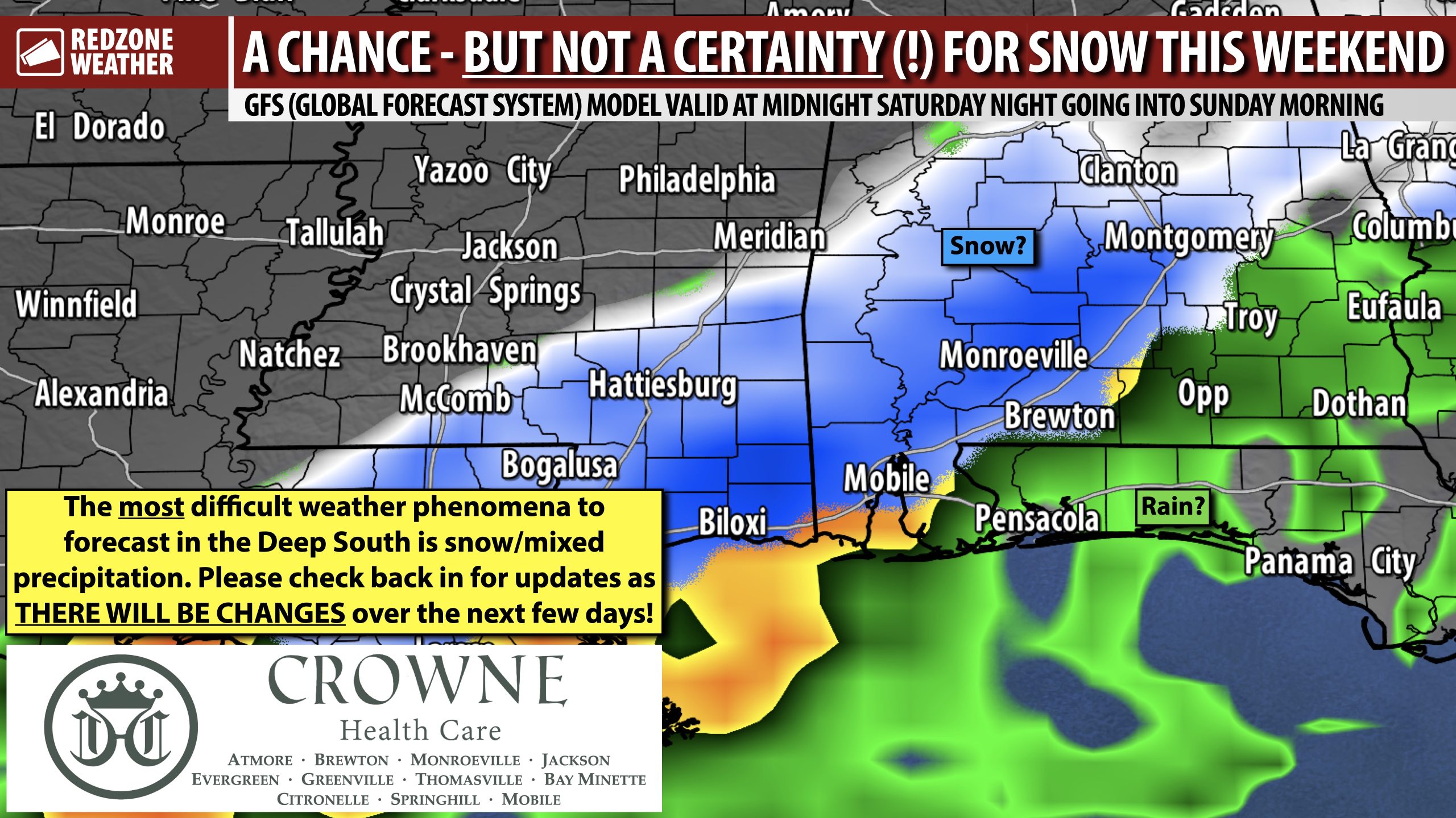
MAJOR UNCERTAINTY REGARDING POTENTIAL RAIN/SNOW EVENT THIS WEEKEND… While it is nearly impossible to predict details, today has featured consistent trends in the guidance pointing to the potential for rain and perhaps some snow across parts of the Deep South this weekend. Major, and I truly mean MAJOR, uncertainty exists regarding exactly what will happen. If you’re reading this in south Alabama or northwest Florida, I cannot (nor can anyone!) tell you if it will snow this weekend. What I can tell you is there is *at least a chance* – which is higher than 99% of the time here when it’s too warm. Confidence is very high we will have cold air in place across the Deep South. Confidence is much lower, however, regarding precipitation placement or IF precip will happen at all. After trending drier over the last couple of days, today has been the polar opposite with models trending toward a wetter/snowier potential across the region.
THIS PROBABLY WILL NOT BE NOTHING LIKE THE JANUARY 2025 “ONCE IN A LIFETIME” SNOW… This will be much different than the January 2025 “once in a lifetime” snowstorm that blanketed parts of our area with almost one foot of snow. That was a total daytime event. This will likely be a near total nighttime event that peaks in coverage between midnight and 6AM Sunday morning, based on the Wednesday evening data.
RAIN CHANGING OVER TO SNOW: MOST LIKELY SCENARIO… The data points to rain starting Saturday night and changing over to snow some time late Saturday evening or even after midnight early Sunday morning. No way to know at this point how long snow would last (probably less than 2-3 hours at most) or how much accumulation will happen (likely less than 2″ in most spots – but that means very little at this point).
SNOW IS THE TOUGHEST WEATHER PHENOMENON TO FORECAST IN THE DEEP SOUTH… Forecasting the future is tough. Just ask folks over on ESPN who try to forecast who will win college football games. Forecasting weather is also tough, but thankfully we have some skill and data to help guide us, even if the outcome is nowhere near perfect. Forecasting tornadoes and severe thunderstorms has arguably had the most progress over the last 50 years. Forecasting hurricanes has drastically improved overall, even in the past 20 years. Forecasting snow in the Deep South is like throwing darts in the night. It ain’t easy – and that’s putting it mildly. The reason for this is because it’s a rare event. Generally speaking, the more an event happens (thunderstorms as an example – we get them every, single month of the year!), the easier it is forecast. Snow only happens once every few years, on average, meaning the data set for models to compare analogs is tiny, in comparison. This is one of the reasons you see models waffling significantly ahead of Deep South snow events. That process will continue over the next couple of days. I imagine we will have a much better handle of what will happen this weekend on Friday.
DON’T CHANGE ANY PLANS JUST YET – TOO EARLY FOR CHANGES… It is too early to cancel or modify events on Sunday morning. There is a real chance some communities remain completely dry or simply have rain around and not much else. Some communities, however, may have accumulating snow before all is said and done on Sunday morning. It’s just too early to know details. My advice this evening: I wouldn’t cancel or modify my plans if I were in your shoes. Give it a day or two and by Friday, we should know much more.
HARD FREEZE TOMORROW NIGHT INTO FRIDAY MORNING… Hard freeze conditions are expected tomorrow night. The confidence level on this is near certain. Outside of the snow potential, we have a hard freeze set to happen tomorrow (Thursday) night into early Friday morning. Air temperatures will dip to the 20-25° range tomorrow night with wind chill values as low as 15-17° expected across inland communities. Most spots will be below freezing for a good 10-12 hours from 9PM tomorrow night to 8-9AM Friday.
THANKS IN ADVANCE FOR YOUR PATIENCE AND KINDNESS… Around here, I have always tried to “shoot it to you straight,” even when I don’t have all the answers. I certainly don’t have all the answers about the snow potential and probably won’t for a couple of days. Anyone that claims they do is not being truthful. We should all expect surprises with this event on Saturday. We may get to the point where it looks like most of us will just have rain and some communities end up with some surprise snow. On the flip side, we may see a true rain to snow changeover event with some spots getting 4 inches of snow. Making things even tougher, some spots may have no precipitation at all. We simply don’t have enough data to make any firm statements on this Wednesday evening. Thank you for reading and thank you for understanding that we’re dealing with the atmosphere – the ultimate chaos generator. Check with me in the days ahead as we go through this process of refining the forecast.
APP… If you haven’t already downloaded the RedZone Weather app, now is a great time to do that. redzoneweather.com/app is the link to the free download. Once you have the RZW app installed on your iOS or Android device, be sure to visit the Alerts tab to turn on the specific notifications you’d like to receive. All notifications are handcrafted by me. No automation and we promise not to bug you!
I will have the latest forecast rundown posted in the morning forecast video tomorrow morning at 7:15AM. Hope you’ll join me then for the latest info.
Have a nice Wednesday evening!
