RAIN MAY TRANSITION TO SNOW, BRIEFLY PERHAPS, SATURDAY NIGHT… Confidence is increasing this evening that south Alabama and northwest Florida may have some rain and potentially some flurries or snow showers early Sunday morning, likely before sunrise in many communities. This will very likely be exclusively a nighttime event. Some minor accumulation could be possible, specifically across inland areas of southwest Alabama. Model trends today have suggested that a cold rain (and not snow) may end up being the most likely scenario. Some surprises are also possible, as is always the case when we have wintry precipitation across the local area. I outline more in the “all or nothing” paragraph below. Before we get to the snow potential, RAIN will be possible Friday night into early Saturday morning. I expect rain to clear out early Saturday morning, giving way to a mostly dry day. Rain returns Saturday night ahead of a potential changeover to snow early Sunday morning.
TIMING – RAIN THEN SNOW… Two, distinct periods of rain are possible – one round happens late Friday night into early Saturday morning as rain showers move from northwest to southeast across the region. Thunderstorm action will be quite limited and no severe storms are expected. We dry out Saturday during the late morning and afternoon hours. The next round of showers will start most likely after 6PM Saturday. The greatest probability of snow happens from 10PM Saturday to 6AM Sunday as a band of precipitation moves from west to east across the local area. Rain/snow clears out to the east by 8-9AM Sunday morning. There is a real chance some communities remain precipitation free for the duration of the event, particularly closer to the coast. One scenario that could happen involves rain happening, followed by flurries, with no accumulation.
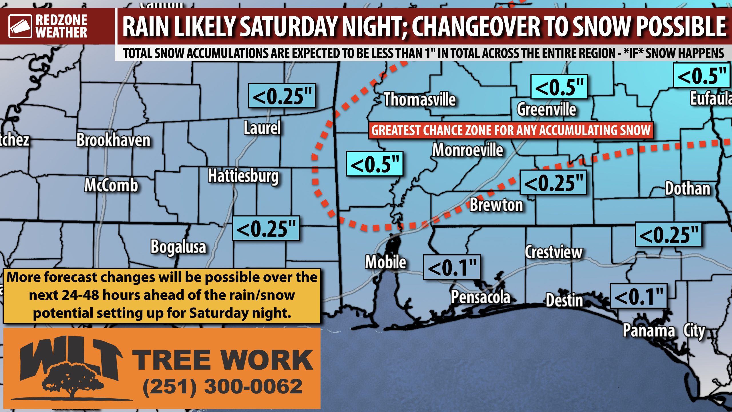
ALL OR NOTHING SCENARIOS… Let’s talk about the two extreme scenarios. What happens if the right set of ingredients comes together, temperatures are a hair below guidance, and precipitation over-performs? 0.75 to 1″ of snow inland with upwards of 0.25″ of snow closer to the coast. That’s an outlier, high-end scenario. What about the other end of the spectrum? Also a possibility, and I would lean toward this over the higher-end scenario, based on the latest data. In that scenario, we just have a cold rain Sunday morning with no snow. The truth of what will actually happen will likely fall in the middle of those two extreme scenarios. I suspect some communities will have minor snow accumulations inland. I’m not so sure about accumulating snow closer to the coast. Could it happen? Yes. Will it happen? I tend to doubt it based on the temperature profile closer to the coast AND the bulk of the precipitation likely to happen a bit further inland. Of course, we may get some new data tomorrow that shifts the precipitation axis closer to the coast. Uncertainty continues but details are getting a bit more clear this evening. This looks like a relatively low-end event with a cold rain being highly likely with a small amount of flurries or snow on the back side of the exiting precipitation.
TRAVEL IMPACTS & ROAD CONDITIONS… The greatest potential for accumulating snow will happen across inland areas of southwest Alabama, although there is a real chance that even in that zone, precipitation happens in the form of rain exclusively. Slick spots on local roads will be possible from 10PM Saturday to 9AM Sunday, depending on if a specific location receives precipitation. Regardless of what happens specifically, I would go ahead and plan to stay where you are Sunday morning, at least through 9-10AM IF you’re a person who plans on the course of least regret. Even small amounts of snow can create very slick spots on local roadways. I would imagine if you’re headed out to a morning worship service Sunday morning after 10AM, you will be in good shape across the vast majority of our local area. The reason for this is temperatures will rapidly climb above freezing Sunday morning after 7-8AM. This will help to mitigate more widespread, major travel issues.
DON’T CHANGE ANY PLANS JUST YET – TOO EARLY FOR CHANGES… It remains too early to cancel or modify events on Sunday morning. There is a real chance some communities remain completely dry or simply have rain around and not much else. Some communities, however, may have accumulating snow before all is said and done on Sunday morning. It’s remains too early to know specific details for specific communities. My advice this evening: I wouldn’t cancel or modify my plans if I were in your shoes. Give it a day or two and by tomorrow evening, we should know much more.
HARD FREEZE TONIGHT INTO FRIDAY MORNING… Hard freeze conditions are expected TONIGHT. Outside of the snow potential, we have a hard freeze set to happen tonight into early Friday morning. Air temperatures will dip to the 20-25° range tomorrow night with wind chill values as low as 15-17° expected across inland communities. Most spots will be below freezing for a good 10-12 hours from 9PM tonight to 8-9AM Friday.
APP… If you haven’t already downloaded the RedZone Weather app, now is a great time to do that. redzoneweather.com/app is the link to the free download. Once you have the RZW app installed on your iOS or Android device, be sure to visit the Alerts tab to turn on the specific notifications you’d like to receive. All notifications are handcrafted by me. No automation and we promise not to bug you!
I will have the latest forecast rundown posted in the morning forecast video tomorrow morning at 7:15AM. Be sure to join me then for the latest info.
Have a great Thursday evening!
