SIGNIFICANT ICE STORM MAY HAPPEN ACROSS PARTS OF THE DEEP SOUTH THIS WEEKEND… Major disruptions may be possible across parts of the Deep South during the upcoming weekend due to what could be a prolific and significant winter storm, likely in the form of an ice storm. This could be a widespread, significant event that extends from Texas to the Carolinas, including a large chunk of the Deep South. It is impossible 4 days out to nail down specifics of what individual communities can expect, but model guidance has been trending toward a very impactful storm that could cause major disruptions across the Deep South. Uncertainty remains quite high with specifics but we’re beginning to be able to see that this could be a higher-end system in terms of overall impacts.
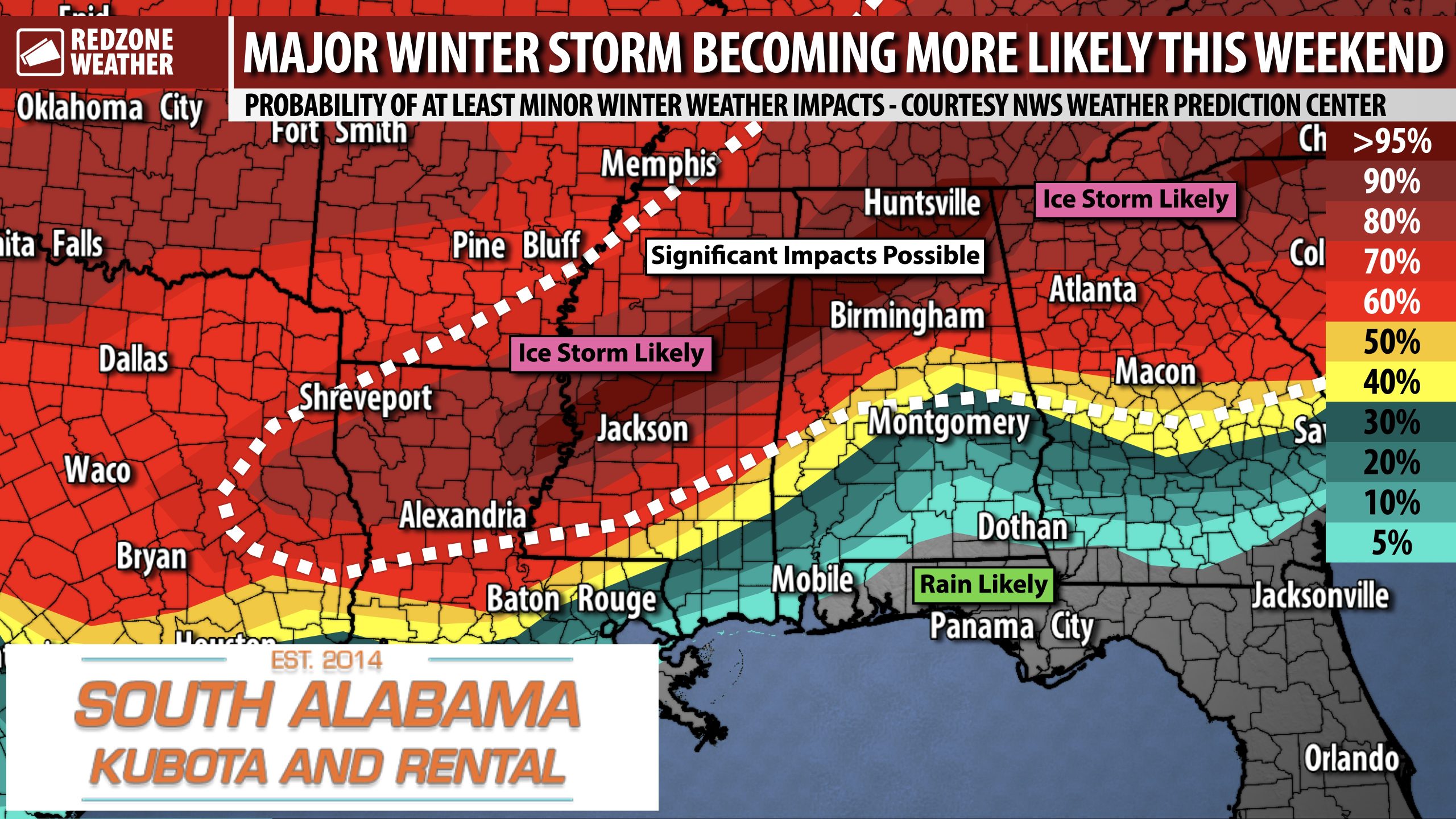
The map attached is the Probability of AT LEAST Minor Winter Weather Impacts from the NWS Weather Prediction Center (WPC). This metric is the percentage of the winter storm causing at least minor disruptions, including potential road/travel issues. Confidence is growing in potentially significant impacts for parts of north Louisiana, north Mississippi, north Alabama, north Georgia, Tennessee, and the Carolinas.
LOCAL IMPACTS DISCUSSION – SOUTH ALABAMA AND NORTHWEST FLORIDA… Fortunately for much of south Alabama and northwest Florida, right now it looks like our local area will be on the “warm” side of this system for much of the weekend. This means that precipitation will likely happen MOSTLY in the form of rain. Sleet and freezing rain may become a problem for parts of southwest Alabama on Sunday. It is too early to be able to get specific about what communities receive rain versus sleet or freezing rain. Unfortunately, this does NOT look like a snow event like what happened last weekend. Rain quickly changed over to snow without much incident last weekend. This weekend is a totally different animal. Widespread freezing rain/ice will happen in areas JUST to our north and west. WAY too close for comfort. Further forecast changes in the days ahead may shift the freezing rain zone into parts of our region. Please check back in for updates in the days ahead.
FURTHER FORECAST CHANGES LIKELY… We are still 3-4 days out from this event starting. That means that further changes to the forecast are expected. Winter storms are notoriously difficult to forecast in the Deep South, largely because of the infrequency between events. Ice storms don’t happen often, but when one does happen, significant impacts can become possible. In this case, this looks like a widespread, significant event. Please check back in for updates in the days ahead.
MAJOR IMPACTS POSSIBLE IN PARTS OF NORTH MS, NORTH AL, NORTH GA, AND TN… You don’t see a setup like this very often. The potential exists for what could be a crippling, widespread ice storm, perhaps extending across a very large swath of the American South. Some of the global models are showing total freezing rain accumulations of 1+ inches. That may not sound like a lot, but remember that 0.25″ of freezing rain can cause MAJOR problems. The issue is that freezing rain falls as a liquid (as rain) and then instantly freezes on contact with whatever it encounters. The weight of freezing rain can topple power lines, causing widespread, significant, and potentially long-lasting power outages. Combine that with the forecast of VERY cold temperatures and you can see why the potential exists for major, major problems. Right now, the highest probability for ice storm impacts looks to be across parts of northern Louisiana, north Mississippi, north Alabama, Tennessee, and into north Georgia and the Carolinas. Forecast changes are LIKELY over the next few days.
VERY COLD CONDITIONS EXPECTED NEXT WEEK… Warmer temperatures are in store, briefly, for south Alabama and northwest Florida on Thursday and Friday when afternoon highs will be in the 60s and near 70°. Temperatures will progressively fall this weekend. Next week, we’re expecting HIGHS in the 40s with multiple nights of subfreezing temperatures. I expect multiple hard freeze nights to happen next week. The entirety of the eastern half of the continental United States will have an Arctic, polar air mass in place that will keep temperatures substantially below climatological averages for this time of year.
APP… If you haven’t already, be sure to download the free RedZone Weather app to keep up with all the latest information on the world of weather in south Alabama and northwest Florida. redzoneweather.com/app is the link for the free download. Once you have the app downloaded to your iOS or Android device, be sure to visit the Alerts tab (lower right corner) and tap the Alert Settings button to customize the alerts you would like to receive straight from me.
I will have the latest forecast rundown posted in the morning forecast video tomorrow morning at 7:15AM. Be sure to join me then for the latest info.
Have a great Tuesday evening!
