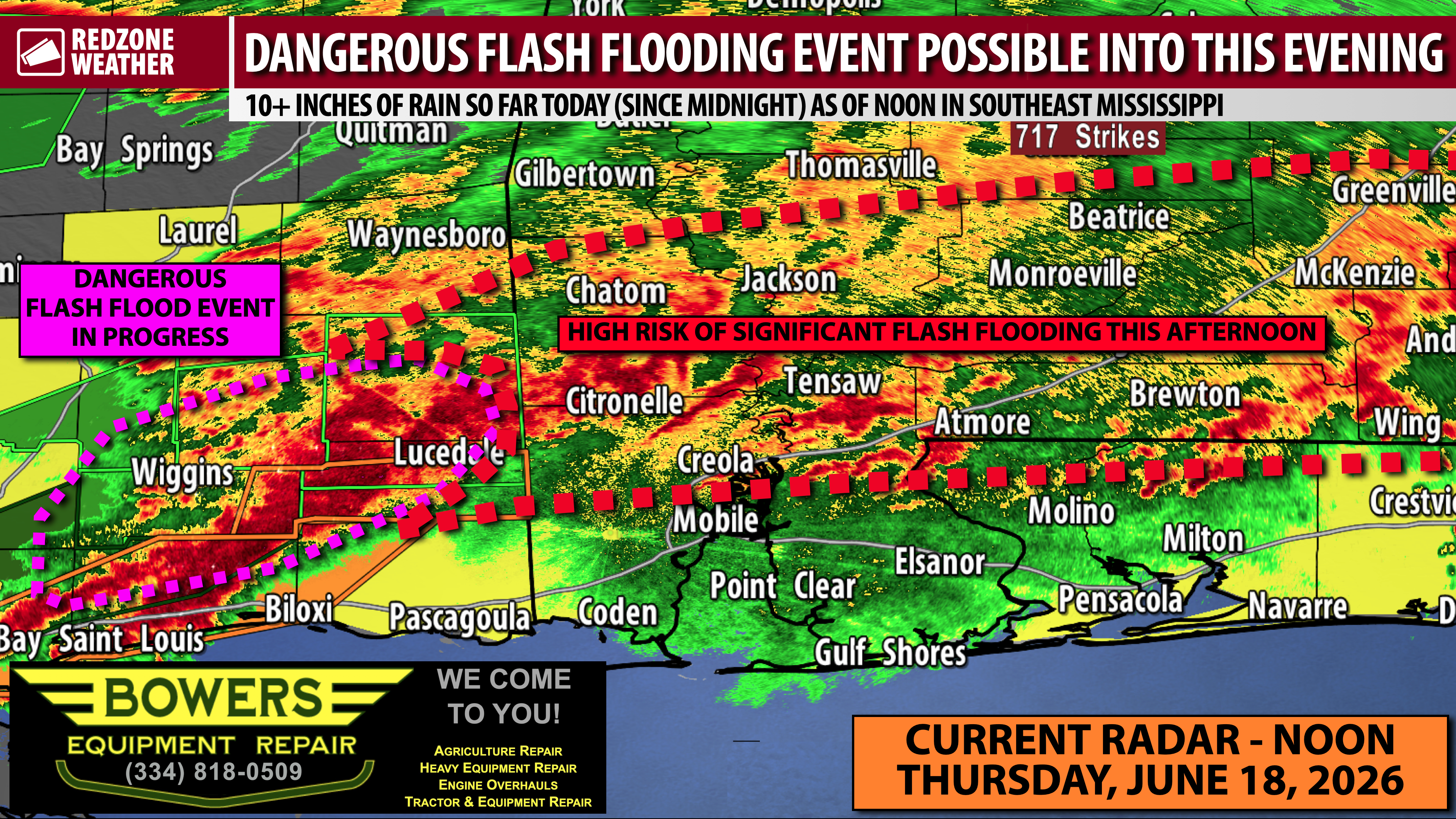
10+ INCHES OF RAIN SO FAR IN S.E. MISSISSIPPI; FLASH FLOODING TO START SOON OVER S.W. ALABAMA… Stone County EMA reports that they’ve had 10+ inches of total rainfall since midnight at the Stone County EOC at Wiggins, Mississippi. According to viewer reports, several water rescues have happened in southeast Mississippi in the last few hours. A rare Flash Flood EMERGENCY is in place for all of Stone County with Flash Flood Warnings up for Greene, George, Perry, Harrison, Pearl River, and Hancock counties in southeast Mississippi. This is setting up to be a very dangerous flash flood event that is expected to get worse.
FLASH FLOOD PROJECTION – LOCAL AREA… Heavy downpours continue across parts of southwest Alabama and the far interior stretches of northwest Florida at Noon. I expect the overall situation to support flash flooding, particularly across parts of northern Mobile, northern Baldwin, Escambia (AL), Covington, Conecuh, Butler, Monroe, Clarke, and Washington counties in the hours ahead. It cannot be emphasized enough: DO NOT attempt to drive across a water-covered roadway! We lose way too many people across America each year thinking they can drive through water and ending up getting swept away. It’s totally preventable. “Turn around, don’t drown!”
RIVERS AND CREEKS… In addition to the immediate flash flooding threat, we are also going to have to monitor local rivers and creeks for aerial or long form flooding tomorrow and into the weekend. More rain is in the forecast at times on Friday. Flood prone areas may begin to experience rapidly rising water as early as this evening or tonight, depending of course specifically on how much rain falls in a given basin. We encourage everyone to heed flood warnings! A Flood Watch is in effect for all local counties through tomorrow night.
UPDATE ON THE TORNADO RISK… We had a couple of tornado warnings earlier in parts of southwest Alabama, specifically in Mobile and Washington counties. Numerous tornado warnings have happened in southeast Mississippi. We had a few areas of rotation that we tracked toward the end of our live round of coverage in Baldwin County. A few more tornado warnings are not out of the question over the next several hours. Please have a way to hear urgent weather warnings though this evening. A Tornado Watch continues for all local counties valid until 5PM. It remains to be seen if this will be extended into the evening hours.
TORNADO WARNING POLICY… Any time there is an active tornado warning in effect for southwest Alabama or northwest Florida, we provide uninterrupted, live video coverage on Facebook Live and YouTube Live. Our detailed coverage commitment is outlined at redzoneweather.com/coverage. We are proud to cover all parts of Escambia (AL), Covington, Monroe, Conecuh, Baldwin, Mobile, Clarke, Washington (AL), Butler, Escambia (FL), Santa Rosa, and Okaloosa counties. If you live in any locale in those counties, be sure to tune into our coverage whenever there is an active tornado warning!
APP ALERTS… redzoneweather.com/app is the link where you can download the free RedZone Weather app. We post brief updates throughout each day in the app, keeping you up-to-date about the latest happenings in weather across south Alabama and northwest Florida. Once you have the free app downloaded to your iOS or Android device, be sure to visit the Alerts tab (lower right corner) then tap the large Alert Settings button to customize the alerts you would like to receive straight from me.
I will have live coverage for tornado warnings as needed this afternoon with many, many more updates being posted all afternoon and evening in the RedZone Weather app. My next detailed forecast video will be posted by 7:15AM tomorrow morning.
Have a nice Thursday afternoon and please stay safe!
