
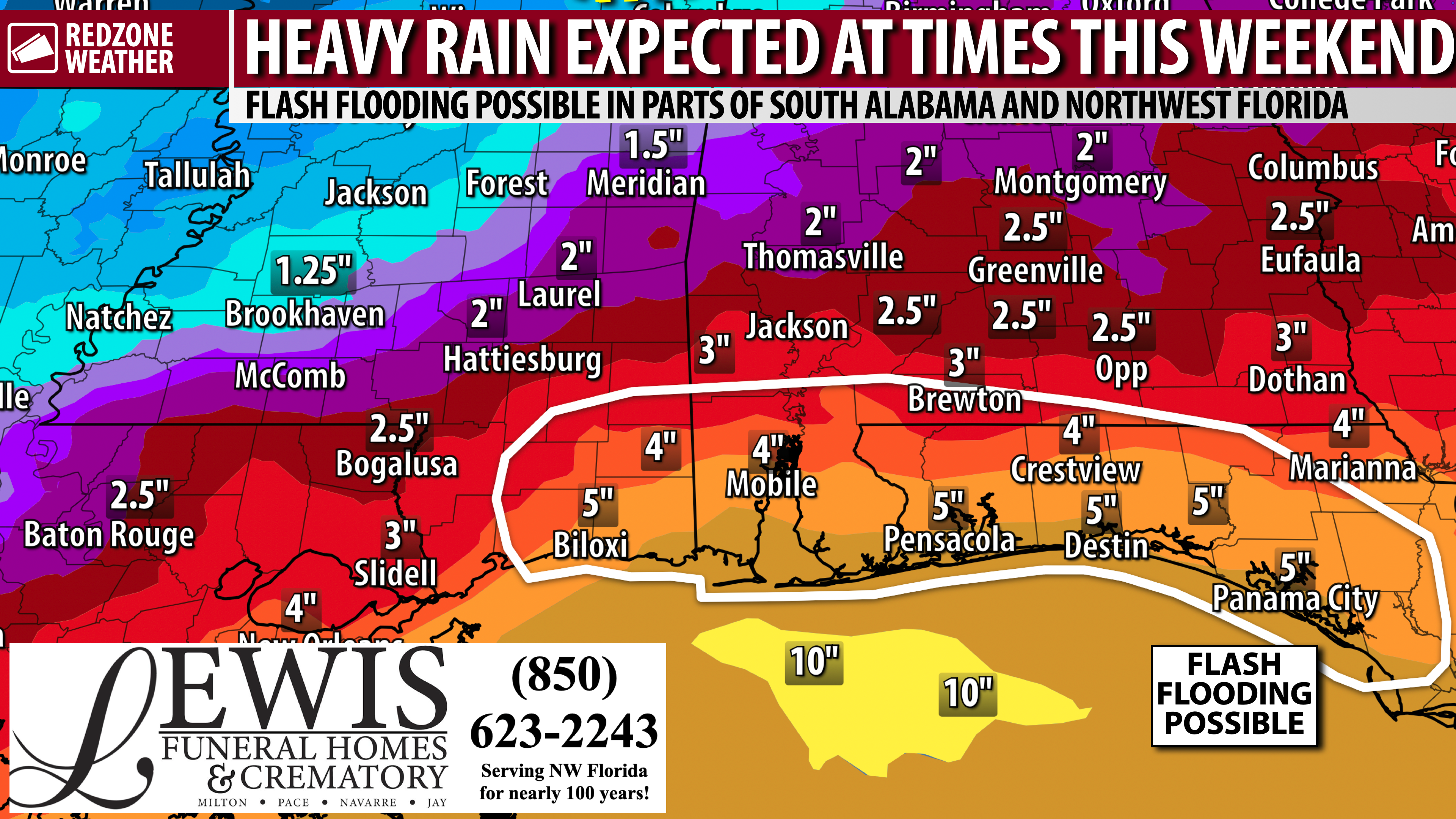
HERE COMES THE RAIN – WEEKEND EXPECTED TO HAVE RAIN & THUNDERSTORMS… We’re set to enter a significantly wetter weather pattern on Friday, Saturday, Sunday, and into Monday as deep tropical moisture moves into south Alabama and northwest Florida. For now, this looks like a big rain event through the weekend with multiple rounds of rain being likely. The good news is the overall severe weather risk remains LOW for now. Maybe not entirely zero, particularly Saturday P.M. I suspect the main issue in the days ahead will be a lot of rain capable of producing isolated instances of flash flooding. Cloud-to-ground lightning will be a concern in the storms that develop as well. There has been a lot of online chatter about a potential Gulf tropical system in 10-14 days. Details about that are below.
WHAT TO EXPECT – TOMORROW (THURSDAY)… Spotty, brief thunderstorms will be possible throughout the day, starting first at the coast and progressing inland in the afternoon and evening hours. I am not expecting much, if anything, in the way of severe weather impacts. Lightning and brief downpours are the main concern tomorrow. The best chance of rain will happen from 3PM to 9PM, but again, activity is expected to be quite spotty in nature tomorrow.
HEAVY RAIN AT TIMES FRIDAY… Rain becomes more likely. We probably will have multiple rounds of rain throughout the day. The best rain chances will happen in the afternoon and evening hours, most likely. Occasional thunderstorms will be involved as well. At this point, there is no formal risk of severe storms, meaning I am not concerned as much about tornadoes or damaging wind gusts. Heavy rain and lightning could be problematic at times. It probably will not rain all day Friday. Instead, multiple waves of rain will be possible. An uptick in severe weather potential does not seem particularly likely on Friday, but this is something I will be monitoring just in case we see changes.
SATURDAY AND SUNDAY WILL BE WET AT TIMES… The weekend will be quite wet in many communities, plain and simple. Rain and thunderstorms will be possible all weekend long. The greatest chance of rain looks to be Saturday P.M. into Saturday night and early Sunday morning. IF (and that’s a big IF) we see any severe storm development through the weekend, I suspect it would be Saturday evening around the northwest Florida coast, most likely. Even there, the risk isn’t anything notable at this point, but if the parameter space changes and we do see a low-end risk set up, I would think it would be near the beaches in NW FL on Saturday P.M. Rain will likely be more continuous on Saturday into Saturday night in some communities across the region. Flash flooding could become a problem if storms train over the same areas. Generally, the closer you are to the coast, the higher your risk of flash flooding this weekend into early next week.
GULF & CARIBBEAN QUIET; TROPICAL MISCHIEF IN 10-14 DAYS?… The Gulf and Caribbean Sea will remain quiet over the next 5 days, in terms of an organized tropical storm or hurricane threat – there is no threat through at least Tuesday of the upcoming week. I would not be surprised if the National Hurricane Center chooses to flag the southwestern Gulf (Bay of Campeche region) with a low-end development probability for the END of next week. There has been intermittent model support of a tropical storm developing toward the end of next week in the southwestern Gulf and generally moving northeast, perhaps toward our area OR perhaps toward the Florida Big Bend or even the Florida Peninsula. It’s simply too soon to know any real details. We’re in the VERY early phase of watching this. Quite frankly, a lot of weather pages (and even professional meteorologists) have really honed in on this feature. I suspect this is because hurricane season in the Gulf has been remarkably quiet, so far, so a lot of these folks are chomping at the bit to post anything that looks like tropical trouble. Long-time viewers and readers know I prefer to take a more reserved approach and not hype these things into oblivion. For now, just an idea in the model data we will watch in the days ahead.
APP… If you haven’t already downloaded the RedZone Weather app, now is a great time to do that. redzoneweather.com/app is the link to the free download. Once you have the RZW app installed on your iOS or Android device, be sure to visit the Alerts tab to turn on the specific notifications you’d like to receive. All notifications are handcrafted by me. No automation and we promise not to bug you!
I will have a full forecast rundown posted by 7:15AM tomorrow morning with the latest details. Hope you will join us for that.
Have a good Wednesday evening!
