
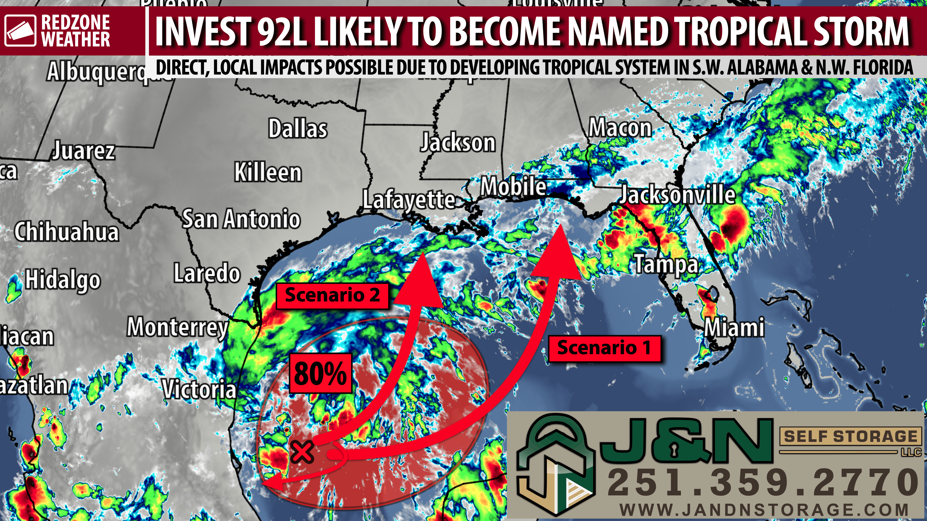
GULF STORM LIKELY TO DEVELOP; RANGE OF OUTCOMES FOR THIS WEEKEND… What we know this evening is that chances for a tropical storm developing in the southwestern Gulf continue to increase. We also know that part of the Deep South is about to get a whole lot of rain that could lead to flooding. What we don’t know just yet is where the system will ultimately end up or how strong it will be. We’re still quite early in the forecasting process and there remain quite a few questions that can’t be answered just yet. Welcome to the world of meteorology where a lot can and WILL change over the next few days as more data comes in. This evening, I’ve prepared a range of scenarios that could happen in the days ahead, hopefully better clarifying some of the mechanics of the forecast. While I can’t tell you just yet what will happen in your hometown, I can tell you about the overall pattern that could bring potentially significant impacts to our region later this week (or not!) and why. Here are the details.
SCENARIO 1: STORM DEVELOPS QUICKER, BECOMES STRONGER, AND MOVES OUT QUICKER… A tropical storm or category 1 hurricane develops on Wednesday or Thursday before making landfall along the Mississippi, Alabama, or northwest Florida coast. This scenario would give the storm more time over the warm waters of the central Gulf before a landfall further east, as in east of Louisiana. Local impacts in south Alabama and northwest Florida would largely be dependent on where the center of the storm moves ashore. So even in this one scenario, there is a range of possibilities. IF the storm made landfall anywhere west of Pensacola, that would put the bulk of our region on the “bad” eastern side of the storm where wind impacts, heavy rain/flash flooding, and tornadoes would likely be worse. On the flip side, if the storm makes landfall somewhere east of Destin, much of our area would be on the “better,” west side of the storm. This scenario would be more of a wind issue with quite a bit of rain, but not as much rain/flooding as the scenario below. The reason this scenario COULD happen? Main reason is more time over the warm waters of the Gulf and the storm would not be dealing with drier air to the west over Texas and western Louisiana.
SCENARIO 2: STORM DOES NOT DEVELOP OR REMAINS WEAK, MOVES SLOWER… The system fails to develop into a named tropical storm and instead produces a long-form, major rain event across Louisiana, Mississippi, Alabama, and Florida from Friday through Sunday. This could end up being the worst scenario as far as heavy rain and flash flooding with some locales near the coast likely picking up 10-12″ of rain. Isolated tornadoes may still be possible but the overall, significant wind threat would be less in this scenario. The reason this scenario COULD happen? Higher amounts of atmospheric shear, keeping the system in check, along with dry air filtering into the system from the west. The storm would be more “lopsided” in nature with the bulk of the impacts happening on the east side of the storm.
SCENARIO 3: STORM REMAINS BASICALLY STATIONARY FOR DAYS… This is more of an outlier scenario at this point, but we note that some of the major weather models kept the storm in the Bay of Campeche in the southwestern Gulf for longer (into the weekend) before steering the system into Mexico as a much weaker storm perhaps next week. The odds of this happening seem to be rapidly decreasing, but the small possibility is still there.
SO WHICH SCENARIO WILL HAPPEN?… That’s the million-dollar question this evening and one that I cannot answer (nor can anyone, just yet). I would tend to lean toward something like Scenario 1 with a faster track toward the MS/AL/FL coast on Friday or Saturday, but that is strictly based on the latest model data I have seen. It’s simply too early for anything concrete. Everyone from Louisiana to Florida (including Mississippi and Alabama folks) should monitor this system carefully over the next few days.
APP ALERTS… redzoneweather.com/app is the link where you can download the free RedZone Weather app. We post brief updates throughout each day in the app, keeping you up-to-date about the latest happenings in weather across south Alabama and northwest Florida. Once you have the free app downloaded to your iOS or Android device, be sure to visit the Alerts tab (lower right corner) then tap the large Alert Settings button to customize the alerts you would like to receive straight from me.
I will have more updates posted in the days ahead in the RedZone Weather app. My next regularly scheduled forecast video will be posted by 7:15AM tomorrow morning. Hope you will join us for that.
Have a great Monday evening!
