
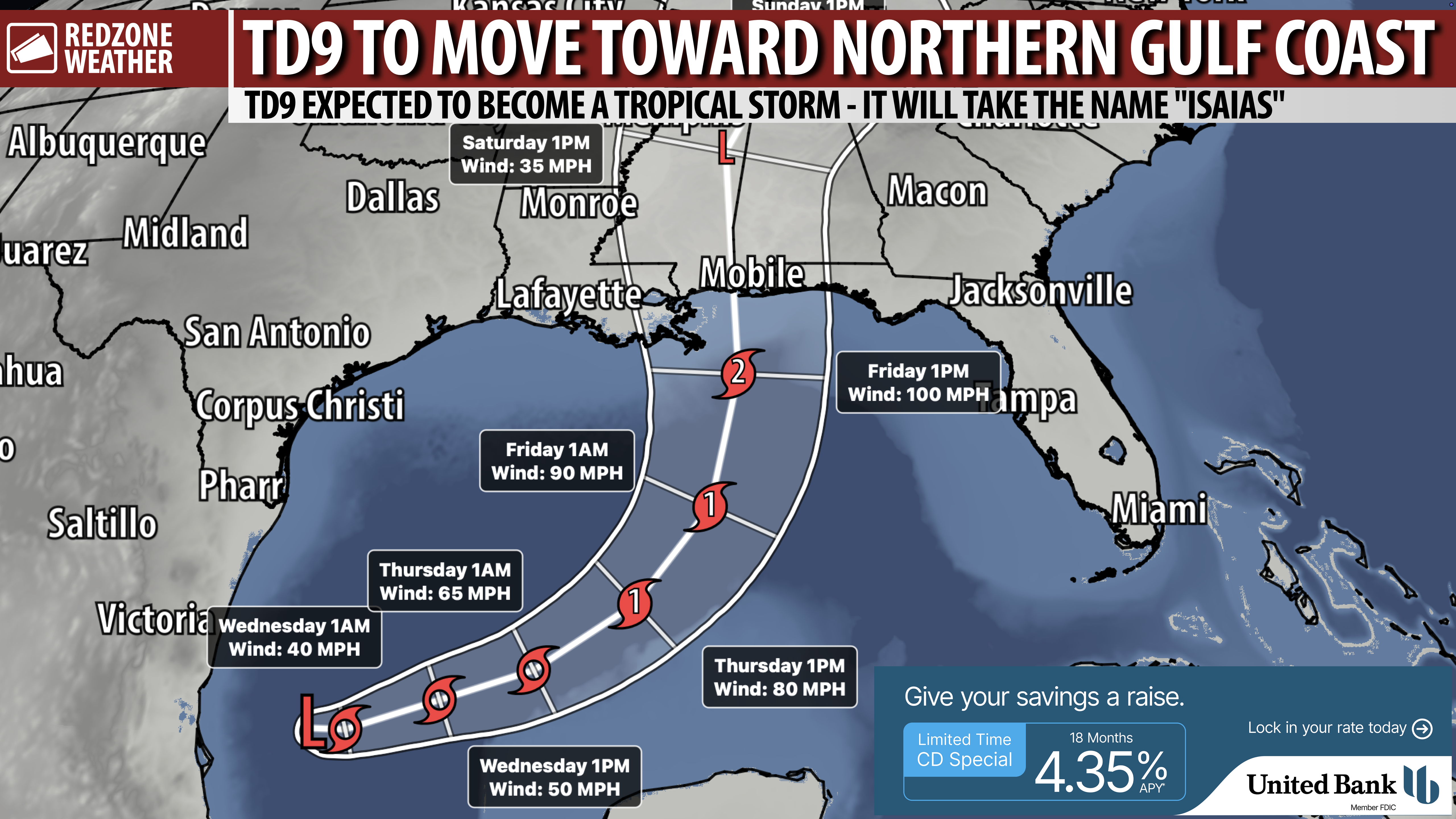
TD9 EXPECTED TO BECOME TROPICAL STORM; LOCAL HURRICANE IMPACTS LIKELY INTO WEEKEND… Tropical trouble is brewing in the southwestern Gulf this evening with the potential for significant impacts becoming possible across parts of Louisiana, Mississippi, Alabama, and northwest Florida later this week and into the weekend. The National Hurricane Center has started advisories as of 4PM on newly designated Tropical Depression Nine, the system that was previously INVEST 92L. TD9 will move east a bit before moving north tomorrow into Thursday. There is a good chance the system is rather lopsided in nature with most of the impacts happening on the eastern side of the storm. Keep in mind, anytime you are looking at a “cone of uncertainty” projected path (like what is pictured here), that is the forecast for the CENTER of the storm. Impacts WILL extend well out from the center.
While some uncertainty continues to exist in the forecast, model guidance has firmed up in the idea of potential impacts for parts of Louisiana, Mississippi, Alabama, and northwest Florida at some point from Friday through Saturday. There continues to be a range of outcomes as to exactly what will happen, but confidence is growing that at least some local impacts will happen.
We note NHC ramps the system up to a category 2 hurricane with maximum winds of 100 mph just before landfall Friday night.
LOCAL IMPACTS DISCUSSION – S.W. ALABAMA & N.W. FLORIDA… Heavy rain is expected at times this weekend. Flash flooding will become a concern where rain and thunderstorms train over the same areas. Our local area will likely be on the “messy,” eastern side of the system where impacts are a bit greater than the western side. This points to heavy rain, flash flooding, tornadoes, gusty winds (particularly at the coast), at least some level of storm surge, and coastal flooding. There will likely be a prolonged period of time where tornadoes become possible across the region this weekend. Now is the time to start thinking about this, knowing where you would go and what you would do if a tornado warning becomes required for your specific location.
STORM TIMING – TD9… No significant weather impacts are expected locally through Thursday, other than dangerous surf and rip currents at the beaches. Direct local impacts in Alabama and northwest Florida would happen likely from Friday P.M. through Saturday, and into Sunday, IF current forecast guidance continues to hold. I realize we have a lot of events locally AND across the Deep South going on this weekend, including the big Alabama-Georgia game scheduled for Saturday night in Tuscaloosa. Please know that game very well could be affected by heavy rain at times.
FORECAST TRACK & INTENSITY GUIDANCE BECOMING MORE CLEAR… Now that we have a low-level center of circulation developing with TD9, models will begin to “initialize” better, meaning the models will have a better grasp of where the center of the storm currently is. This leads, over time, to a better understanding of where the center of the storm will ultimately go. Right now, the system is merely a blob of thunderstorms in the southwestern Gulf starting to swirl around a common center. A Hurricane Watch will likely be required for parts of Louisiana, Mississippi, Alabama, and northwest Florida by tomorrow evening.
TRACK SHIFTS WILL LEAD TO MAJORLY DIFFERENT OUTCOMES… Please remember that even small shifts in the projected path of this developing tropical system will cause potentially significant shifts in the outcomes of what happens at a specific location. This means that even if the core of the system makes landfall in Louisiana or Mississippi, impacts are LIKELY in south Alabama and northwest Florida. There is also a growing chance of direct hurricane impacts in parts of southwest Alabama and northwest Florida as the system approaches.
SET UP APP ALERTS… We send quite a bit of Low-Level Alerts in our RedZone Weather app. The app is totally free for you! redzoneweather.com/app is the link where you see the download links to your respective app store for iOS and for Android devices. Once you have the app downloaded to your smartphone or tablet device, be sure to visit the Alerts tab to customize the alerts you would like to receive straight from me.
I will have more updates posted in the RedZone Weather app over the next few hours. I will have another detailed update posted across our social media platforms and in the app a bit later this evening.
