
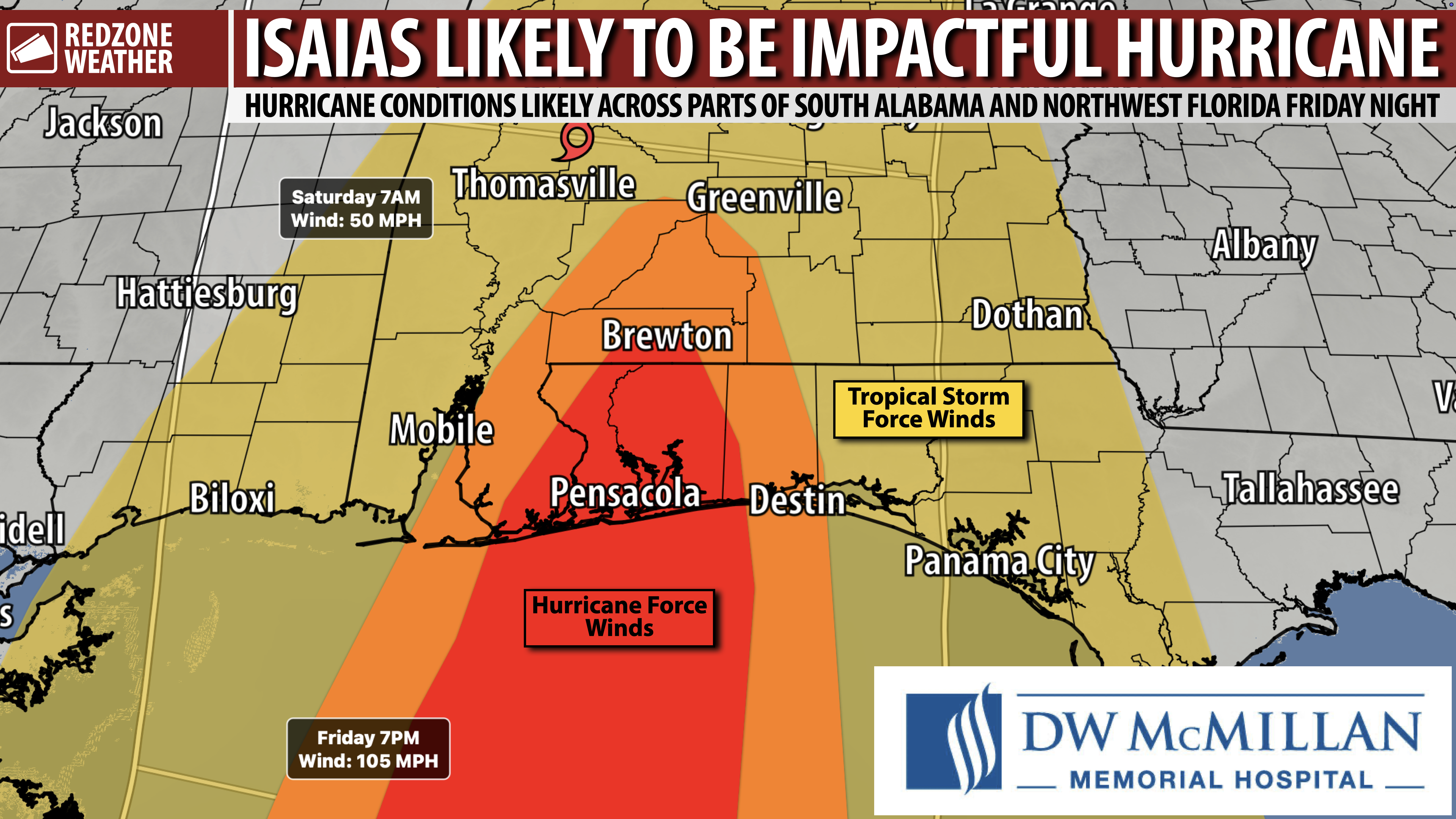
HURRICANE WATCH POSTED FOR LOCAL AREA; ISAIAS TO BRING BIG IMPACTS FRIDAY NIGHT INTO SATURDAY… A Hurricane Watch has been issued for the northern Gulf Coast from Bay St. Louis, MS to Indian Pass, FL. Tropical Storm Isaias, currently gaining strength in the southwestern Gulf as of 10AM Tuesday, is forecast to move toward the northern Gulf Coast. Landfall of the storm is likely in our local area in south Alabama and/or northwest Florida Friday night or Saturday, likely as a hurricane. This will be a very significant, impactful storm for a large chunk of our region. A hurricane is not a point, it’s a large storm, but the landfall point will determine a lot concerning “who gets what impact.” Right now as of the 10AM Wednesday advisory, the cone of uncertainty extends from Pass Christian, MS (near Biloxi) to Laguna Beach, FL (near Panama City).
HURRICANE WATCH UP FOR THE NORTHERN GULF COAST… Mobile, Baldwin, Escambia (FL), Santa Rosa, Okaloosa, Walton, Bay, and Gulf counties are now under a Hurricane Watch. Jackson and Harrison counties in Mississippi are also included in the Hurricane Watch. A Tropical Storm Watch has been issued for eastern Louisiana and for places east of Indian Pass in the Florida Panhandle region. A Hurricane Warning will be needed tonight or tomorrow for our local area.
ISAIAS: WIND – WIDER AREA OF WIND IMPACT LIKELY COMPARED TO SALLY & ZETA… We are looking at what could be our most impactful hurricane in quite some time across south Alabama and northwest Florida. This will be different than what happened with Hurricane Sally and Hurricane Zeta in 2020. Both of those storms caused significant damage, but the damage was confined to specific parts of our region. What will be Hurricane Isaias is likely to cause wind damage across a wider area. To be clear: Every community in south Alabama and northwest Florida is LIKELY to have at least tropical storm force winds (39+ mph). The hurricane force winds (74+ mph) are forecast to be in a much narrower zone. The center/landfall point will determine who gets the hurricane force winds.
ISAIAS: STORM SURGE… The storm surge threat will maximize near and east of the center of circulation associated with what will likely be Hurricane Isaias. 3-6 feet of storm surge possible near the center, 1-3 feet of storm surge much further east in the Florida Panhandle all the way over to Apalachicola.
ISAIAS: TORNADOES POSSIBLE… Tornadoes will be possible near and east of the center of the storm. This likely puts a large swath of south Alabama and northwest Florida in the potential tornado zone. Tornadoes will be most likely to happen late Friday evening into Saturday morning. The tornado threat will expand into central and north Alabama throughout the day on Saturday. Be able to hear tornado warnings! Have the tornado helmets ready.
ISAIAS: FLASH FLOODING POSSIBLE… Forward speed of the storm will be increasing on Friday. This bodes well for the heavy rain and flash flooding potential. While some isolated locales may pick up 6-12″ of rain, MOST of us across south Alabama and northwest Florida will likely have 3-6″ of rain in total from this system. Flash flooding will be a significant concern where storms train during the storm. There is a chance we could see quite a bit of rain ahead of the storm on Friday in some spots, particularly closer to the coast. IF that happens, the flash flooding threat would be greater.
GET PREPARATIONS DONE TODAY AND TOMORROW!… Nice, partly cloudy skies are expected today and tomorrow (Thursday). Perfect for hurricane prep! People that prepare for storms have much better outcomes than people who don’t, plain and simple. Now is the time to start hurricane preparations if you have not already done so. I typed up a fairly exhaustive list of things you can do to prepare here: https://www.facebook.com/rzweather/posts/pfbid02uUYxGkjA2nsEStS8TzpisL7YqVLMGSyx8MctNif5wiSmfGqDrAk1CS1wMXcQLCn6l
APP ALERTS… redzoneweather.com/app is the link where you can download the free RedZone Weather app. We post brief updates throughout each day in the app, keeping you up-to-date about the latest happenings in weather across south Alabama and northwest Florida. Once you have the free app downloaded to your iOS or Android device, be sure to visit the Alerts tab (lower right corner) then tap the large, yellow Alert Settings button to customize the alerts you would like to receive straight from me
NEXT UPDATE… My next detailed update concerning Tropical Storm Isaias will be posted by 4:15PM. Until then, plenty more updates will be posted in the RedZone Weather app.
Have a nice Wednesday!
