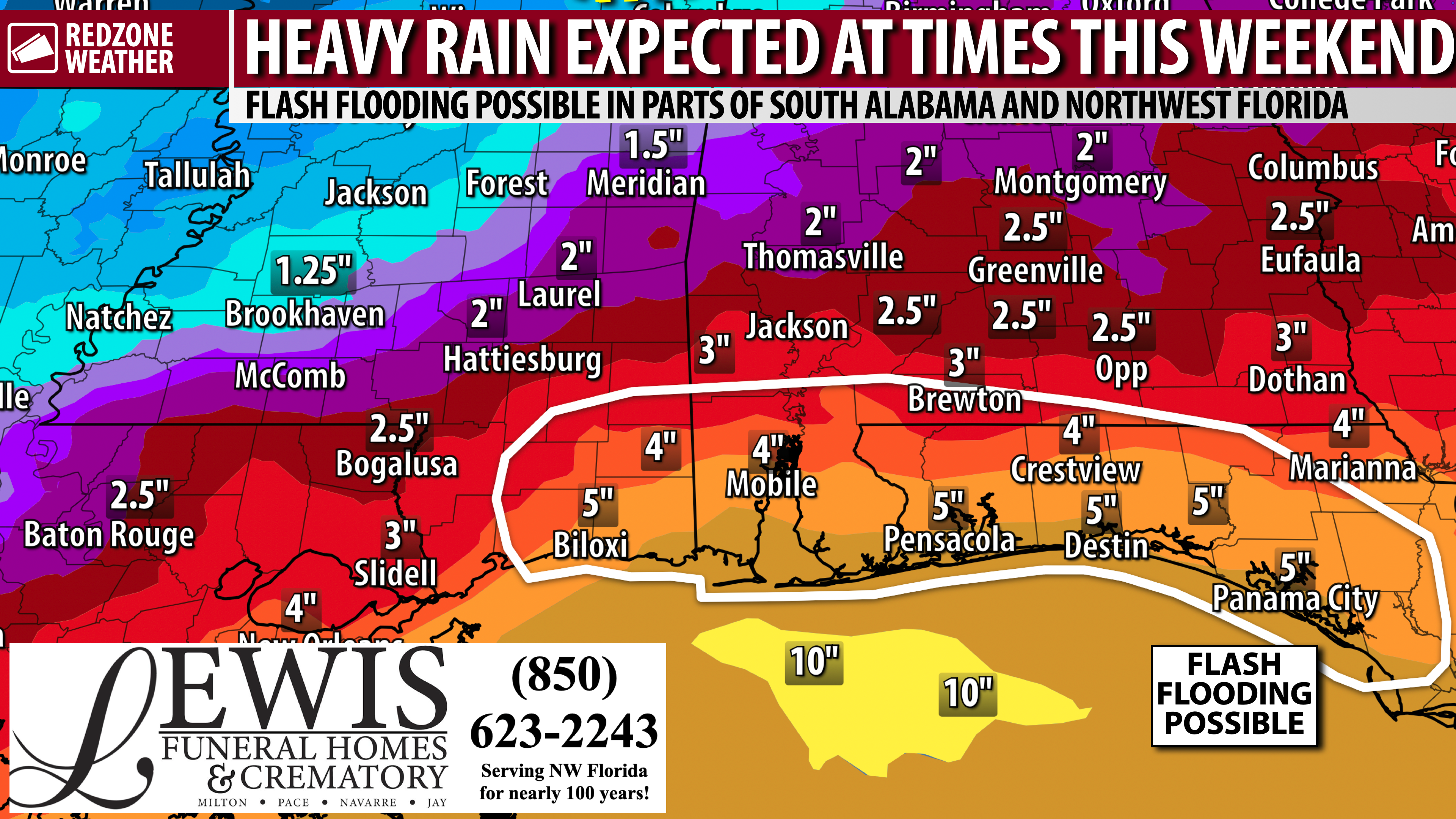
SPOTTY STORMS TODAY; HEAVY RAIN & STORMS LIKELY AT TIMES FRIDAY, SATURDAY, AND SUNDAY… Scattered showers and thunderstorms will become possible across south Alabama and northwest Florida today as moisture continues to increase across the region. A mix of sun and clouds is expected with high temperatures generally around the 90 degree mark. Storm coverage will increase considerably tomorrow (Friday) and remain elevated through the weekend. Multiple rounds of rain and thunderstorms may produce locally heavy rainfall Friday through Sunday, with localized flash flooding becoming a concern this weekend. For now, the overall concern is more of a heavy rain and lightning concern as opposed to tornadoes and damaging wind gusts. The risk of tornadoes remains low through the weekend.
A FEW SCATTERED STORMS AT TIMES TODAY… Showers may begin near the coast this morning before scattered showers and a few thunderstorms spread farther inland this afternoon. Rain will not last all day in any one community, and some locations may avoid rain entirely. Most of today’s showers and storms should be brief. There is no formal severe weather risk in place locally today. I will have radar updates posted throughout the day, as needed, in the RedZone Weather app.
INCREASING RAIN CHANCES TOMORROW… Deep tropical moisture will move across the region tomorrow, allowing numerous showers and thunderstorms to develop. Locally heavy downpours will become possible, although there should still be occasional breaks in the rain. High temperatures will be in the upper 80s in most communities. No formal severe weather risk is currently in place locally for tomorrow, with heavy rain being the main concern. Some of the storms will likely be “loud and proud” at times with quite a bit of lightning and thunder.
FRIDAY EVENING LIKELY TO BE WET… Showers and thunderstorms are likely to be around the region Friday evening, potentially affecting high school football games and other outdoor plans. It is not possible to know exactly which communities will have rain in the 7PM-9PM range, and some locations may have extended dry breaks. Any nearby thunderstorm would create lightning concerns, even if the heaviest rain remains away from a particular game.
MULTIPLE ROUNDS OF HEAVY RAIN & STORMS LIKELY SATURDAY… A moisture-rich atmosphere will support multiple rounds of showers and thunderstorms on Saturday. Rain may be intermittent rather than continuous, but outdoor plans could be interrupted at times. Some storms will be capable of producing intense rainfall rates. Localized flash flooding could develop where storms repeatedly move over the same areas, particularly in urban and poor-drainage locations. High temperatures will generally be in the mid to upper 80s.
ACTIVE WEATHER CONTINUES INTO SUNDAY; FLASH FLOODING CONCERNS… Numerous to widespread showers and thunderstorms are expected to continue Sunday as deep moisture pools ahead of a slow-moving front approaching from the northwest. Sunday currently appears to be the wettest day of the forecast period across much of the region. The exact placement and timing of the heaviest rain remain uncertain, but localized flash flooding will be possible where storms train over the same communities. Highs will only be in the upper 70s to low 80s because of the clouds and rain.
MORE SCATTERED STORMS INTO NEXT WEEK… Scattered showers and thunderstorms will remain possible Monday and Tuesday, although rain coverage should gradually decrease compared to the weekend. There is some uncertainty concerning how far south the approaching front will move before stalling or moving offshore. High temperatures will generally be in the upper 70s to low 80s Monday and Tuesday, followed by 70s to near 80° Wednesday. Rain chances will be lower by Wednesday, but not completely zero.
TROPICS: GULF & CARIBBEAN QUIET, FOR NOW… No new tropical storms are expected to develop in the Gulf or Caribbean Sea over the next 5-7 days. We note that some of the longer range models (10-14 days out) have highlighted a potential area of concern in the Bay of Campeche region of the southern Gulf. It’s a bit too early to make any type of determination as to if this system may develop. Just something to watch in the days ahead. Despite a quiet hurricane season so far, it only takes one storm to make it a memorable year for a given area. I’ll have updates posted in the days ahead.
APP… Be sure to have the free RedZone Weather app installed on your phone to keep up with the latest weather information across south Alabama and northwest Florida. redzoneweather.com/app is the link for the free download. After installing the app, visit the Alerts tab to choose exactly which notifications you’d like to receive.
See all the details in your Thursday RedZone Weather forecast video. My next forecast video will be posted by 7:15AM tomorrow morning. I will have updates posted throughout the day, as needed, in the RedZone Weather app.
Have a nice Thursday!