3:38AM January 18, 2026
I am seeing two reports from West Mobile (one viewer report and one NWS employee report) of flurries in the last few minutes. ❄️
— Spinks Megginson (@rzweather) January 18, 2026

I am seeing two reports from West Mobile (one viewer report and one NWS employee report) of flurries in the last few minutes. ❄️
— Spinks Megginson (@rzweather) January 18, 2026
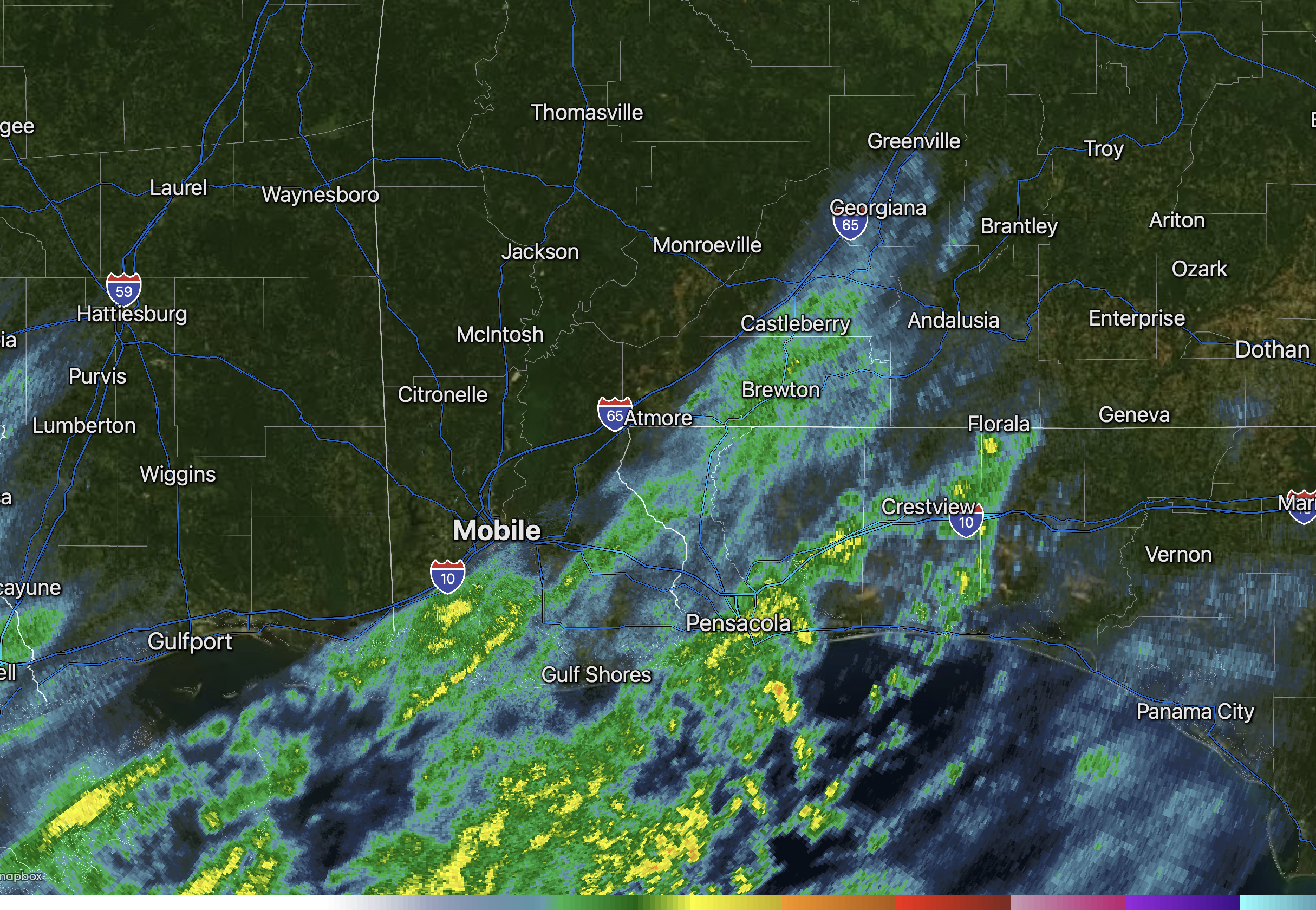
Changeover to snow may be happening across parts of Clarke, Monroe, Washington, and Wilcox counties as temperatures in these counties is now near the freezing mark.
Much of what you see on radar in those counties may not be reaching the ground, however, as dry air rapidly… pic.twitter.com/LXExOexfut
— Spinks Megginson (@rzweather) January 18, 2026

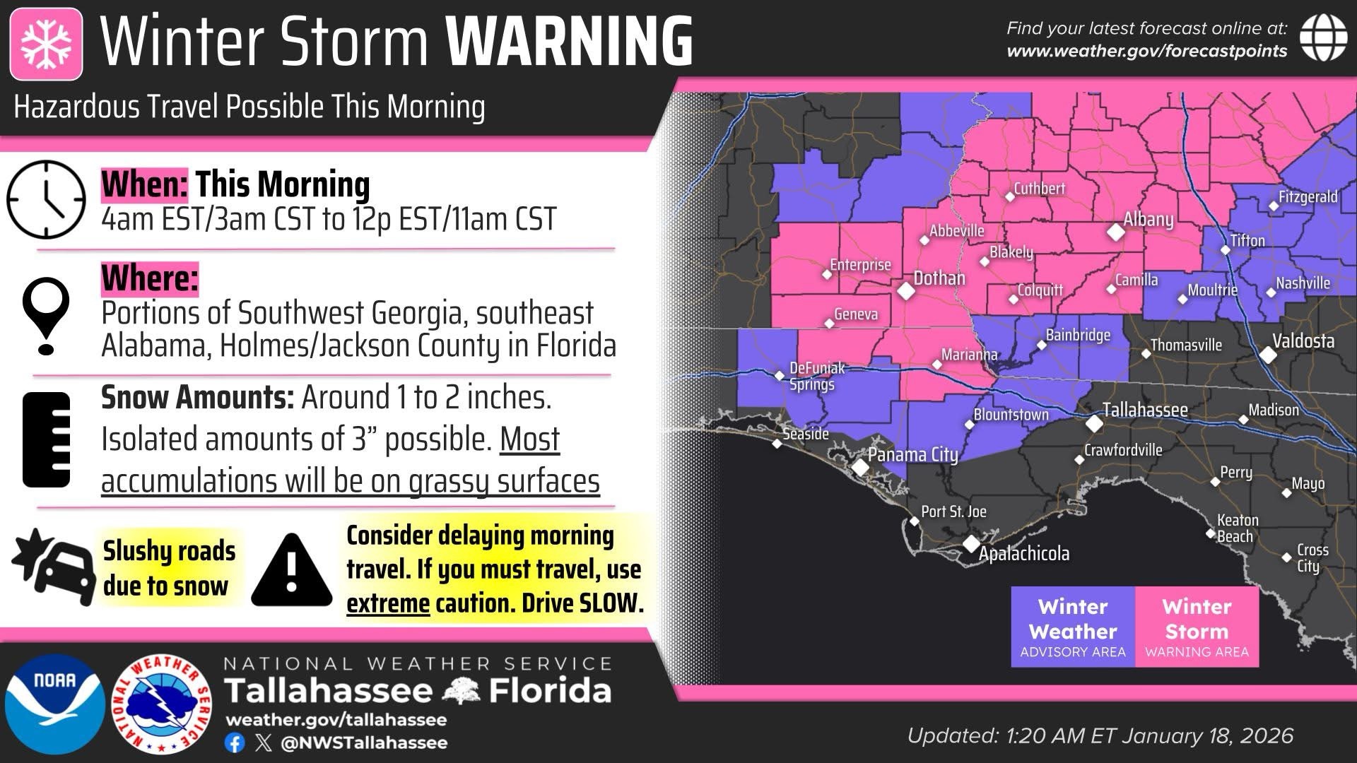
WINTER STORM WARNING FOR SOUTHEAST ALABAMA… Coffee, Dale, Henry, Houston, Geneva, Holmes (FL), and Jackson (FL) counties are now under a Winter Storm Warning.
NWS Tallahassee is projecting 1-2 inches of snowfall in parts of these counties with isolated higher totals being possible.

SCATTERED RAIN MOVING NORTHEAST… Scattered rain showers are moving northeast, just after midnight on this Sunday morning. If you’re waiting on the potential for snow, you may be waiting a few more hours. We’re watching surface observations carefully. Right now, the 32° freezing line is situated in parts of central Alabama. Freezing temperatures are happening as far south as Choctaw, Marengo, Perry, and northern Chilton counties in west-central Alabama.
The overlap of colder air and precipitation may begin around 3-4AM. The overall forecast remains on track. The greatest chance of any minor snow accumulations will happen in parts of Covington, northern Okaloosa, and northern Walton counties and in points to the east of there in southeast Alabama and parts of the Florida Panhandle. South-central Georgia remains the main focal point for heavier snow later this morning.
A brief period of hazardous road conditions may be possible around sunrise and shortly thereafter across parts of the local area if precipitation changes over to snow. Road conditions should improve fairly quickly after 9AM as temperatures rise into the upper 30s and ultimately the 40s later this afternoon.

The scattered rain showers have arrived. Now we wait for the colder air, pushing in from the northwest.
Air temperatures are down to the freezing mark near Livingston, Greensboro, and Calera as of 11:37PM. Freezing line is marching southward. pic.twitter.com/4fotjD1T7w
— Spinks Megginson (@rzweather) January 18, 2026

☔️ Cold rain has begun as the forecast remains on track. Expect rain to persist throughout the night. If you are up early enough (5-7 AM) some lucky areas mainly east of I-65 may see some light rain/snow or all snow. Unfortunately most of it will melt very quickly. #mobwx pic.twitter.com/XPnKVBK7tF
— NWS Mobile (@NWSMobile) January 18, 2026

Spotty rain showers in the Mississippi Sound and the northern Gulf will move into south Alabama and northwest Florida over the next couple of hours.
No snow until after 2-3AM at the earliest, if it happens. Temperatures are still in the upper 30s and low 40s across the region as… pic.twitter.com/ahtGZwrrGz
— Spinks Megginson (@rzweather) January 18, 2026
