
10:52AM May 1, 2026
Scattered sprinkles and areas of light rain continue to move east across south Alabama and northwest Florida as we approach midday. https://t.co/66p4sKX2CV
— Spinks Megginson (@rzweather) May 01, 2026

Scattered sprinkles and areas of light rain continue to move east across south Alabama and northwest Florida as we approach midday. https://t.co/66p4sKX2CV
— Spinks Megginson (@rzweather) May 01, 2026
Active weather will continue today into tomorrow with multiple waves of rain and thunderstorms being possible.
We dry out on Sunday and warm up on Monday.
Another rain chance seems likely around Thursday/Friday of the upcoming week. https://t.co/TH73dTLg0a
— Spinks Megginson (@rzweather) May 01, 2026

RAIN CHANCES INCREASE TODAY INTO TONIGHT; LOW-END TORNADO RISK NEAR COAST INTO TONIGHT… Spotty showers and thunderstorms will gradually increase in coverage throughout the day on this Friday. There will almost certainly be some breaks in the rain throughout the day, so it won’t https://t.co/7Aqt173RfP
— Spinks Megginson (@rzweather) May 01, 2026

RAIN CHANCES INCREASE TODAY INTO TONIGHT; LOW-END TORNADO RISK NEAR COAST INTO TONIGHT… Spotty showers and thunderstorms will gradually increase in coverage throughout the day on this Friday. There will almost certainly be some breaks in the rain throughout the day, so it won’t rain all day in any given community. High temperatures will only be in the upper 60s and low 70s today now that a cooler air mass is in place across much of the region. We may have a low-end severe weather risk that sets up south of I-10 near the Alabama and northwest Florida beaches TONIGHT into early Saturday morning. This will be a quick-hitting event that does not last long at all. The risk will probably
SEVERE WEATHER TIMING – EARLY SATURDAY… 2AM to 9AM is the seven hour window for any strong to severe thunderstorms to happen near the Alabama and northwest Florida beaches on Saturday morning. This means that you’ll need to have a way to hear urgent weather warnings before you go to sleep tonight. The main concern is for areas south of Interstate 10 in Mobile, Baldwin, Escambia (FL), Santa Rosa, Okaloosa, Walton counties, and points east in the Florida Panhandle.
RAIN CLEARS OUT SATURDAY AFTERNOON… Rain and thunderstorms will clear out of south Alabama and northwest Florida from west to east on Saturday in the midday and afternoon hours. Rain may be finished for the day as early as 1PM Saturday in parts of west Alabama and as late as 4PM in Covington and Okaloosa counties on the eastern side of our region. Drier air moves in Saturday night.
SUNSHINE SUNDAY INTO MONDAY… Sunday will be a dry, nice day across the region. Afternoon high temperatures will be in the mid 70s. Chilly temperatures are expected again on Sunday night into early Monday. Overnight lows will be in the mid 40s inland with low 50s as far south as the Alabama and northwest Florida beaches. Monday will be a nice, mostly sunny day with highs in the upper 70s and near 80 degrees.
MORE RAIN AND STORMS POSSIBLE MIDWEEK… Our next chance of rain sets up late Wednesday into Thursday of the upcoming week as a cold front approaches from the northwest. At least some risk of a few strong to severe storms may become possible on Thursday, but it’s a bit too early for specifics. The good news is more beneficial rain will be possible region wide! High temperatures will be in the mid 80s midweek.
APP… If you haven’t already downloaded the RedZone Weather app, now is a great time to do that. redzoneweather.com/app is the link to the free download. Once you have the RZW app installed on your iOS or Android device, be sure to visit the Alerts tab to turn on the specific notifications you’d like to receive. All notifications are handcrafted by me. No automation and we promise not to bug you!
See all the details in your Friday RedZone Weather forecast video. My next forecast video will be posted by 7:15AM Monday morning. I will have updates posted throughout the weekend, as needed, in the RedZone Weather app.
Have a great weekend!

Rain showers will be possible at time throughout the day on this Friday. High temperatures will struggle to hit the 70 degree mark due to all of the clouds and rain around.
A few isolated severe thunderstorms may be possible near the Alabama and northwest Florida beaches later https://t.co/HUn1431aYe
— Spinks Megginson (@rzweather) May 01, 2026

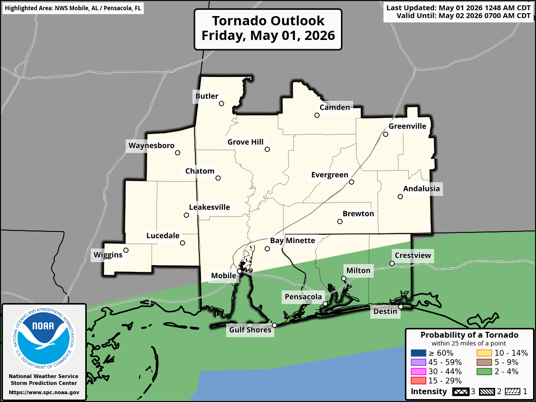
LOW-END TORNADO RISK FRIDAY NIGHT INTO SAT. MORNING… There is a conditional risk (conditional means a certain set of circumstances would have to come together) of a few tornadoes late Friday night into early Saturday morning across coastal Alabama and northwest Florida. Main concern is near the immediate coast.
This will probably be a rain event with a few embedded thunderstorms. Tornadoes are NOT particularly likely. If a warm zone of air from the Gulf sneaks northward into land areas, a brief tornado could happen. Odds of that happening are quite low, but not entirely zero, thus why the Storm Prediction Center has this low-end, Level 1 (out of 5) risk zone in place.

I will have a detailed video update posted by 7:15AM tomorrow morning with a look at specifics on what you can expect tomorrow into tomorrow night. Early indications point to rain and thunder region wide with a low-end tornado potential for areas south of I-10.
See you at 7:15AM https://t.co/CLNXExq4eV
— Spinks Megginson (@rzweather) May 01, 2026
