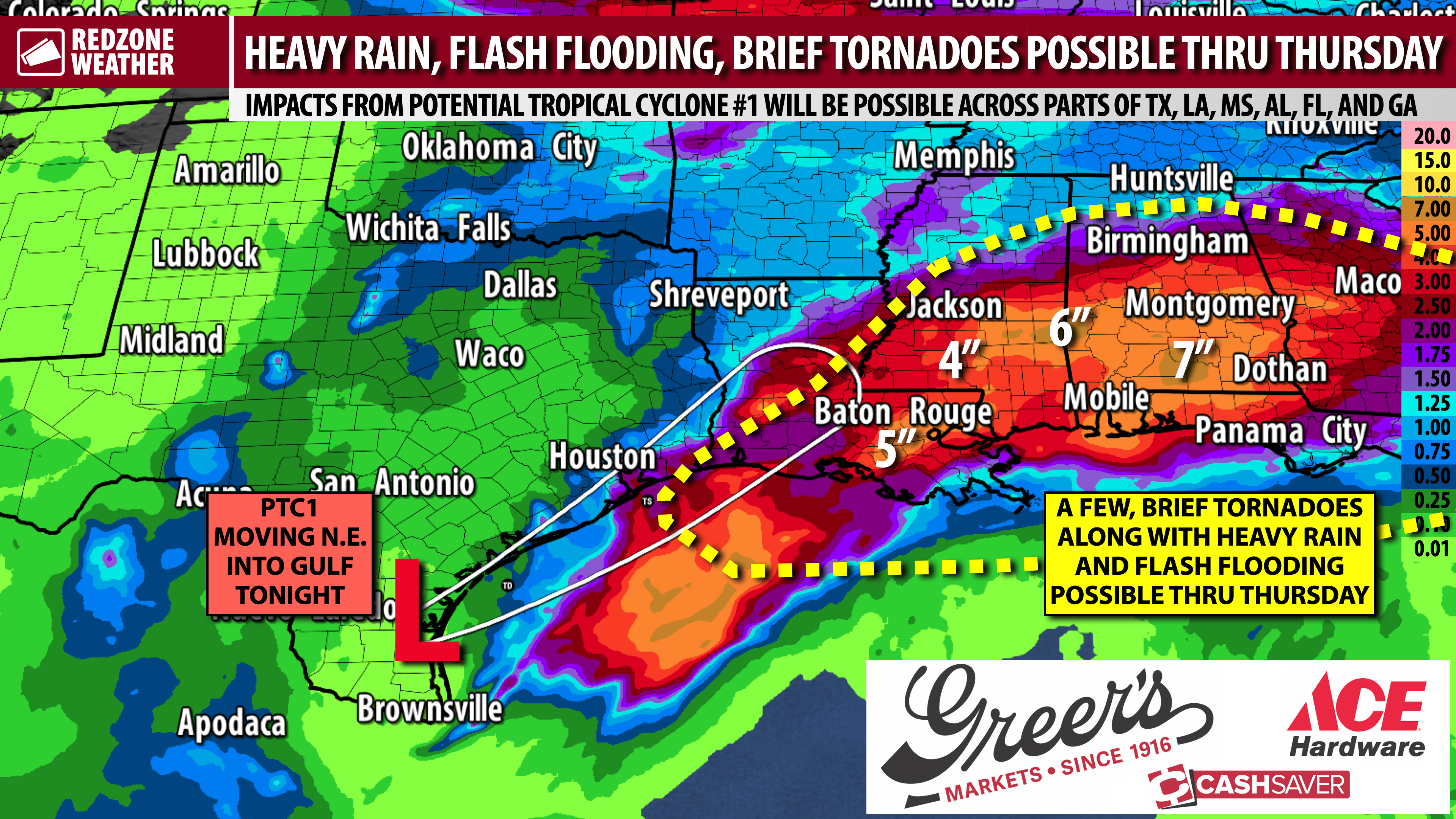
PTC1 FORMS; IMPACTS LIKELY LOCALLY OVER NEXT FEW DAYS; HEAVY RAIN & TORNADOES POSSIBLE… Impacts from a developing tropical storm will be possible across south Alabama and northwest Florida as we get into Wednesday night and Thursday. The National Hurricane Center started updates on Potential Tropical Cyclone (PTC) #1, now located near the south Texas coast, earlier today. PTC1 is emerging into the warm waters of the western Gulf where some strengthening is forecast prior to landfall tomorrow evening near Sabine Pass (TX/LA border). It really won’t matter much at all if the system becomes a named tropical storm or not (name would be “Arthur”) as projected impacts remain the same as if it simply remains an area of low pressure.
FLOOD WATCH LOCALLY; TROPICAL STORM WARNING FOR PARTS OF LOUISIANA… A Tropical Storm Warning is in effect from Morgan City, Louisiana to Sabine Pass. A Tropical Storm Watch is in effect from Sabine Pass down to Sargent, Texas. Tropical Storm Watches and Warnings will not be issued for south Alabama or northwest Florida due to this storm as tropical storm conditions (sustained winds over 39 mph) are NOT expected locally. Regardless of if the system takes a name or not, the impacts remain the same for the local area: Heavy rain, flash flooding, and brief tornadoes are the concerns. A Flood Watch is in effect for ALL local counties until Friday due to the growing risk of heavy rain and flash flooding.
FLASH FLOODING CONCERNS… The latest rainfall projections show an additional 3 to 7 inches of total rainfall expected through Saturday, on top of what happened earlier today. Generally, the heavier rain amounts will likely happen across parts of southwest Alabama, particularly in areas west of the Alabama River. If thunderstorms train over the same areas, a significant flash flood event can’t be ruled out.
LOW-END TORNADO RISK TONIGHT… We are in an ongoing, low-end tornado risk through this evening. A few, weak areas of rotation have been observed across our local area today but so far, no tornado warnings locally. There was a tornado warning earlier this evening in parts of the Florida Panhandle north of Panama City but the storm was very brief and may or may not have produced a brief tornado. I will be carefully monitoring thunderstorms over the next several hours, particularly the storms in Mobile, Baldwin, Escambia (FL), Santa Rosa, Okaloosa, and Walton counties. The risk is much lower further inland from those counties this evening.
LOW-END TORNADO RISK TOMORROW… Tomorrow (Wednesday) will be similar to today with a low-end tornado risk near the coast. Right now, the Storm Prediction Center has parts of Mobile and Baldwin counties included in the low-end tornado risk valid for Wednesday into Wednesday night. The low-end risk extends into coastal Mississippi and into southern Louisiana and east Texas tomorrow. I wouldn’t be surprised if the overall, low-end risk is expanded a bit further into our area for tomorrow. Any tornadoes that develop probably won’t last very long (maybe a few minutes at most) and probably will not be strong. As I often say when I’m in live coverage, however, if a tornado affects YOU, it’s a big deal no matter if it is “weak” or strong. No need to worry, just have a way to hear warnings!
ANOTHER TORNADO RISK ON THURSDAY… The remnants of Potential Tropical Cyclone 1 will be moving closest to our region on Thursday. This will be our most significant weather day of the week, most likely, in that widespread heavy rain and thunderstorms will be the norm. A few, brief tornadoes will be possible across all of south Alabama and northwest Florida and into central and north Alabama as well. It isn’t completely out of the realm of possibilities that a higher risk zone may be needed Thursday if tornado-supporting parameters continue to increase. For now, the Storm Prediction Center has opted to blanket the entirety of Alabama and northwest Florida in the low-end, Level 1 (out of 5) severe weather risk zone for Thursday.
COASTAL IMPACTS… Minor coastal flooding will be possible from Wednesday afternoon, through Thursday, and into Friday morning. The greatest risk of coastal flooding will likely happen near Mobile and the Causeway where coastal flooding of 1-2 feet may be possible. This type of flooding is capable of causing over wash on the Causeway. Very minor coastal flooding impacts could happen near Bayou La Batre, Dauphin Island, Gulf Shores, Orange Beach, and Pensacola Beach. Widespread surge and major impacts are highly unlikely. Dangerous rip currents are expected at all local beaches through the weekend. Red flags will be flying at local beaches with double red flags (beaches closed) being possible.
POP-UP STORMS FRIDAY AND SATURDAY… Showers and thunderstorms will continue to be possible on Friday into Saturday and Sunday, however, widespread severe weather looks unlikely. These will be closer to the “run of the mill” pop-up storms of summer that our region is accustomed to during this time of year. MOST, not all, of the storms will happen in the afternoon and evening hours on Friday, Saturday, and Sunday.
TORNADO WARNING POLICY… Any time there is an active tornado warning in effect for southwest Alabama or northwest Florida, we provide uninterrupted, live video coverage on Facebook Live and YouTube Live. Our detailed coverage commitment is outlined at redzoneweather.com/coverage. We are proud to cover all parts of Escambia (AL), Covington, Monroe, Conecuh, Baldwin, Mobile, Clarke, Washington (AL), Butler, Escambia (FL), Santa Rosa, and Okaloosa counties. If you live in any locale in those counties, be sure to tune into our coverage whenever there is an active tornado warning!
APP ALERTS… redzoneweather.com/app is the link where you can download the free RedZone Weather app. We post brief updates throughout each day in the app, keeping you up-to-date about the latest happenings in weather across south Alabama and northwest Florida. Once you have the free app downloaded to your iOS or Android device, be sure to visit the Alerts tab (lower right corner) then tap the large Alert Settings button to customize the alerts you would like to receive straight from me.
My next detailed forecast video will be posted by 7:15AM tomorrow morning.
Have a nice Tuesday evening!