12:28AM January 14, 2026
Showers will continue to increase in coverage over the next several hours across south Alabama and northwest Florida. pic.twitter.com/jRjfLrWiVa
— Spinks Megginson (@rzweather) January 14, 2026

Showers will continue to increase in coverage over the next several hours across south Alabama and northwest Florida. pic.twitter.com/jRjfLrWiVa
— Spinks Megginson (@rzweather) January 14, 2026
Showers across parts of Mississippi will move into south Alabama and northwest Florida overnight. Rain will be possible at times throughout the day on Wednesday. No severe weather issues expected. pic.twitter.com/tBGsBlqukl
— Spinks Megginson (@rzweather) January 14, 2026

Warmer tonight, with rain showers possible towards sunrise. pic.twitter.com/MXRUIOc2xB
— NWS Mobile (@NWSMobile) January 13, 2026

Showers will become possible overnight into Wednesday morning. Not expecting widespread thunderstorms. No severe weather issues, just rain at times on Wednesday.
This is the projected radar loop valid from this evening at 5PM to 7AM tomorrow morning… pic.twitter.com/3XPuvGv1Cn
— Spinks Megginson (@rzweather) January 13, 2026

COLDER AIR COMING TOMORROW NIGHT… A few rain showers will be possible tomorrow, primarily during the morning hours. We clear out and turn significantly colder tomorrow night. Highs on Thursday will only be in the 40s with mid 20s likely Thursday night!

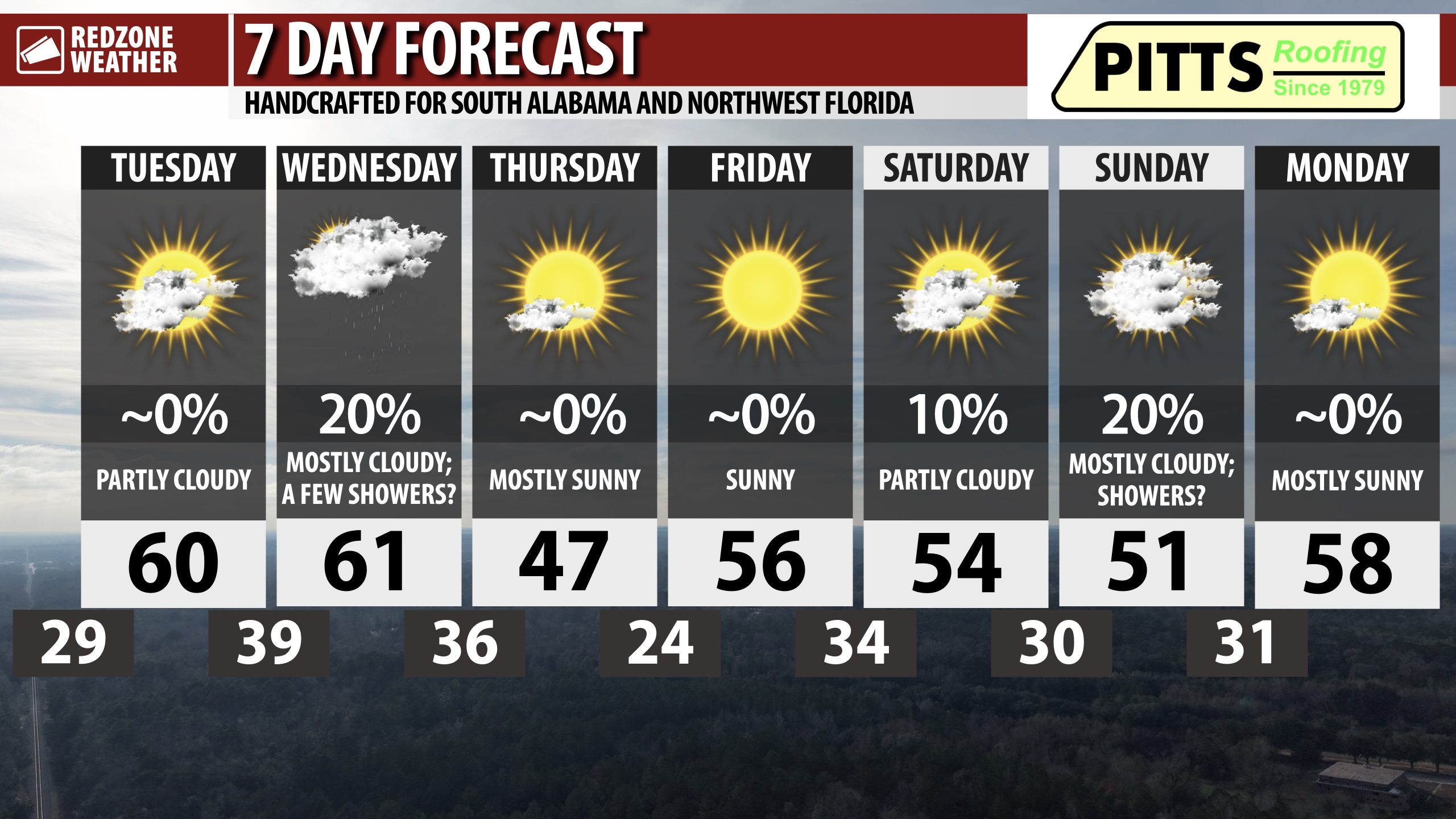
COOL, DRY TUESDAY; FEW SHOWERS ON WEDNESDAY; QUITE COLD ON THURSDAY… After a cold start in the 20s and 30s this morning, temperatures will rise into the upper 50s and low 60s this afternoon. Dry conditions will persist today but we may have a few areas of light rain starting overnight into Wednesday. After the rain ends tomorrow, very cold air arrives tomorrow night. Highs on Thursday will only be in the 40s across our local area. The overall chances of snow/mixed precipitation across the Deep South during the upcoming weekend continues to decrease.
COOL TEMPERATURES TODAY AND TONIGHT; RAIN POSSIBLE OVERNIGHT INTO WEDNESDAY… High temperatures will be in the upper 50s and low 60s today with mostly sunny skies this morning transitioning to partly cloudy skies this evening. Tonight won’t be AS cold as last night. Most communities will be in the upper 30s or low 40s by 6AM Wednesday. Rain will become possible as early as 2-3AM across west Alabama with rain spreading eastward throughout the early morning hours tomorrow. Drizzle and light rain will be possible region wide on Wednesday morning. Lingering showers may be possible into the afternoon hours but I expect an overall drying trend Wednesday P.M.
QUITE COLD THURSDAY; BELOW FREEZING THURSDAY NIGHT… Skies clear out early Thursday morning with temperatures starting out in the 30s. Temperatures won’t recover much at all on Thursday due to an Arctic air mass firmly in place. Afternoon highs on Thursday will be in the mid 40s in most communities. Thursday night into Friday morning will feature a hard freeze across much of the area. Temperatures will dive below the freezing mark around 9PM Thursday night. Most communities will end up in the mid 20s by 6AM Friday.
WEEKEND TRENDING DRIER; SNOW CHANCES LOWER ACROSS DEEP SOUTH… If you were hoping to see some snow across the Deep South this weekend, odds are increasing that you will be disappointed. The overall guidance for the upcoming weekend has trended much drier. While a few sprinkles and showers may be possible at times locally, widespread rain and precipitation looks increasingly unlikely. Flurries may be possible across parts of east Alabama and into Georgia, but even that is highly questionable at this point. I remind folks that what we experienced almost a year ago on January 21 when parts of our area had nearly a foot of snow was quite literally a **once in a lifetime** type event. The last comparison to anything close to January 21, 2025 was back in the year 1895 and even that event did not compare to what happened last January. Generational snow events do happen like the Blizzard of 1993, but even during that event, the Gulf Coast did not have nearly a foot of snow. Don’t let the recent once in a lifetime type snow confuse your perception of what is normal around here – that certainly is not. For now, we will advertise a low-end rain chance for the weekend. No snow locally is in the 7 Day Forecast at this point.
APP… If you haven’t already downloaded the RedZone Weather app, now is a great time to do that. redzoneweather.com/app is the link to the free download. Once you have the RZW app installed on your iOS or Android device, be sure to visit the Alerts tab to turn on the specific notifications you’d like to receive. All notifications are handcrafted by me. No automation and we promise not to bug you!
See all the details in your Tuesday morning RedZone Weather forecast video. My next forecast video will be posted by 7:15AM tomorrow morning. I will have updates posted throughout the day, as needed, in the RedZone Weather app.
Have a nice Tuesday!

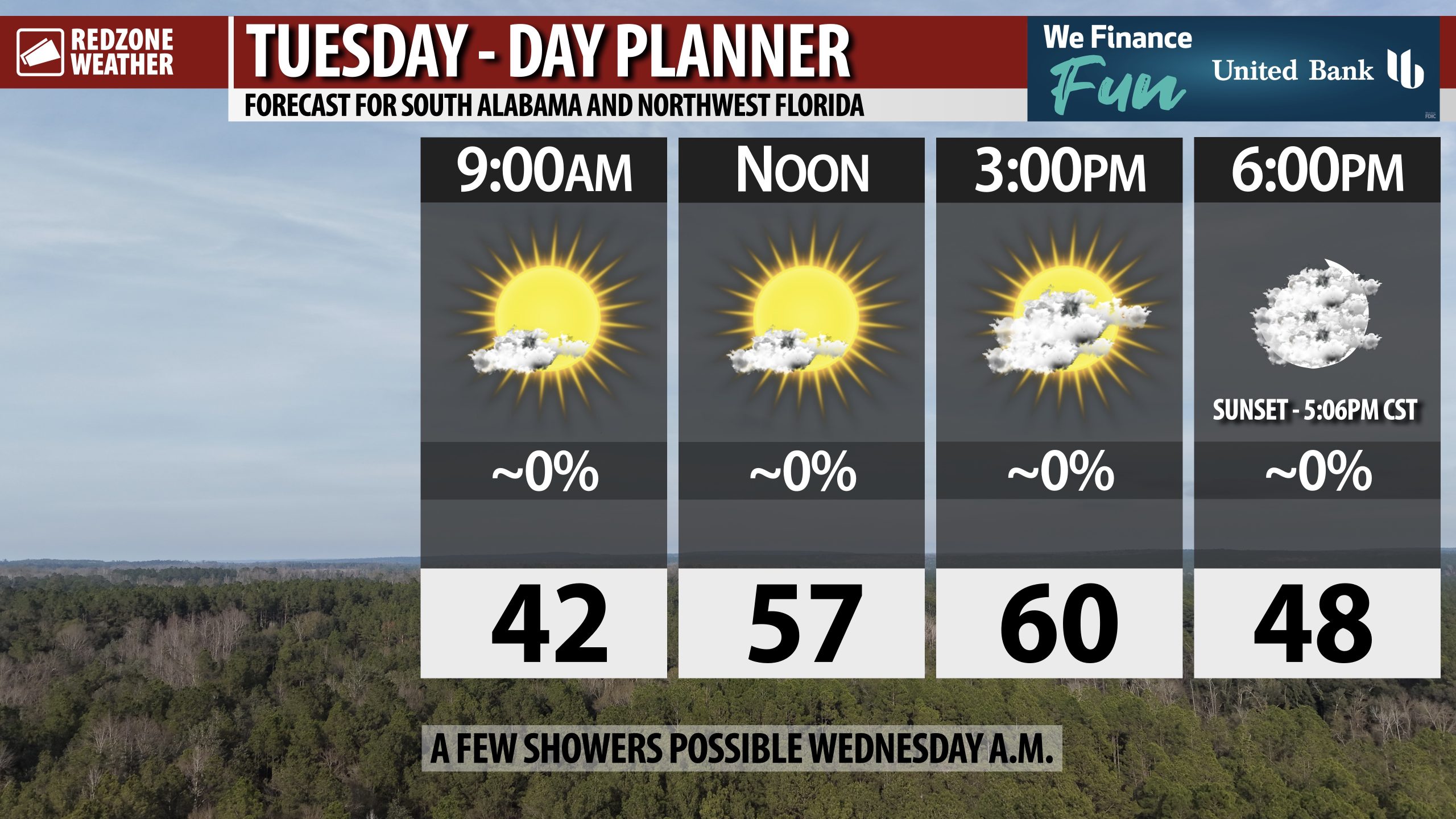
PARTLY CLOUDY TUESDAY; SHOWERS POSSIBLE TOMORROW MORNING… Cloud coverage will begin to increase across south Alabama and northwest Florida this afternoon into this evening. A few showers will be possible tomorrow morning.
High temperatures will be in the upper 50s and near the 60 degree mark this afternoon. Sunset happens at 5:06PM.
Have a great Tuesday!
