
12:53PM May 6, 2026
RT @NWS: Risks for flash flooding Wednesay afternon are rising across the Deep South as thunderstorms increase in coverage and intensity. 2…
— Spinks Megginson (@rzweather) May 06, 2026

RT @NWS: Risks for flash flooding Wednesay afternon are rising across the Deep South as thunderstorms increase in coverage and intensity. 2…
— Spinks Megginson (@rzweather) May 06, 2026
RT @UA_Safety: Due to the threat of severe weather, The University of Alabama will suspend normal operations beginning at 2:30 p.m.
— Spinks Megginson (@rzweather) May 06, 2026

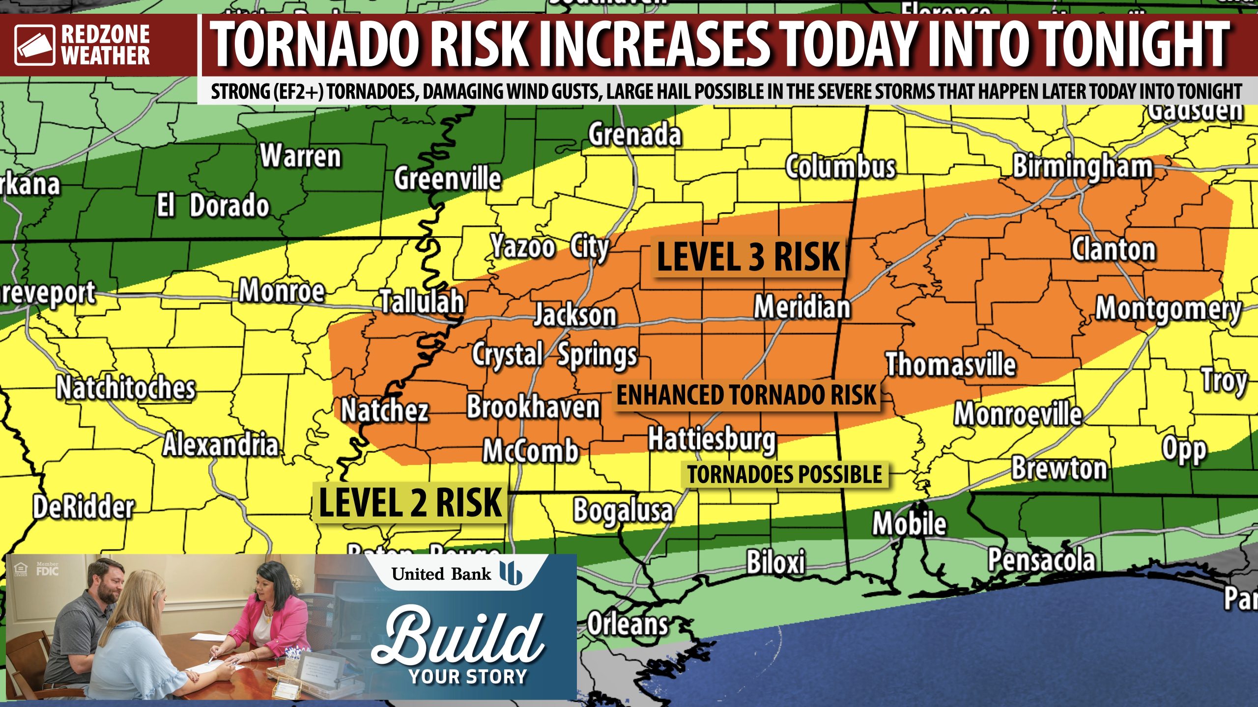
TORNADO RISK INCREASING THIS AFTERNOON IN WEST ALABAMA… Thunderstorms are developing a bit further south compared to earlier guidance, leading to a growing tornado risk for parts of west Alabama in the hours ahead. The Level 3 (out of 5) enhanced severe weather risk has been extended further south into parts of Washington, Clarke, Monroe, Wilcox, Marengo, and Choctaw counties in west Alabama. These are the zones that now have the greatest tornado risk in the hours ahead. In addition to the growing risk, we’re also seeing signs that tornadoes may be possible later this afternoon into the evening hours. That’s on top of the low-end risk that will happen overnight into Thursday morning for the remainder of south Alabama and northwest Florida.
TORNADO WATCH LIKELY THIS AFTERNOON… The Storm Prediction Center indicates a Tornado Watch will likely need to be issued for parts of southeast Mississippi and portions of southwest Alabama this afternoon into this evening. The initial concern will be supercell storms capable of producing tornadoes and large hail. We note that some of the tornadoes that develop could be EF2+ tornadoes, as the environment in place in east MS and west AL is quite volatile this afternoon.
WHAT TO EXPECT – NEXT FEW HOURS IN S.W. ALABAMA… Locally, I am most concerned about Washington, Clarke, Monroe, Conecuh, and Butler counties in southwest Alabama as these are the counties in or immediately adjacent to the higher tornado risk zone. Any supercell thunderstorms that develop in southeast Mississippi and move into southwest Alabama will need to be monitored carefully as tornadoes could quickly become a problem. We encourage everyone to have multiple ways to hear warnings in the hours ahead.
WHAT TO EXPECT – NEXT FEW HOURS IN NORTHWEST FLORIDA & COASTAL ALABAMA… Isolated showers may be possible in parts of coastal Alabama, northwest Florida, and south-central Alabama, but the bigger weather issues are likely to remain to the north of these areas today into this evening. The round of storms will move through these areas likely overnight into Thursday morning. Gusty winds and perhaps a tornado or two will be possible in addition to heavy downpours of rain and quite a bit of lightning.
TORNADO WARNING POLICY… Any time there is an active tornado warning in effect for southwest Alabama or northwest Florida, we provide uninterrupted, live video coverage on Facebook Live and YouTube Live. Our detailed coverage commitment is outlined at redzoneweather.com/coverage. We are proud to cover all parts of Escambia (AL), Covington, Monroe, Conecuh, Baldwin, Mobile, Clarke, Washington (AL), Butler, Escambia (FL), Santa Rosa, and Okaloosa counties. If you live in any locale in those counties, be sure to tune into our coverage whenever there is an active tornado warning!
APP ALERTS… redzoneweather.com/app is the link where you can download the free RedZone Weather app. We post brief updates throughout each day in the app, keeping you up-to-date about the latest happenings in weather across south Alabama and northwest Florida. Once you have the free app downloaded to your iOS or Android device, be sure to visit the Alerts tab (lower right corner) then tap the large Alert Settings button to customize the alerts you would like to receive straight from me.
Have a good Wednesday evening and please stay safe!

TORNADO RISK INCREASING THIS AFTERNOON IN WEST ALABAMA… Thunderstorms are developing a bit further south compared to earlier guidance, leading to a growing tornado risk for parts of west Alabama in the hours ahead. The Level 3 (out of 5) enhanced severe weather risk has been https://t.co/Wpd4CYgMG9
— Spinks Megginson (@rzweather) May 06, 2026

A Tornado Watch will likely be needed in the next several hours for parts of Louisiana, Mississippi, and west Alabama. Developing storms may pose a risk of tornadoes and large hail. https://t.co/TFZcVfKWcz
— Spinks Megginson (@rzweather) May 06, 2026

This developing storm needs to be monitored carefully as it moves ENE across east-central Mississippi. Folks in Choctaw, Marengo, and Sumter counties in west Alabama need to monitor this storm as it moves in from the west. https://t.co/OB50wRbi9x
— Spinks Megginson (@rzweather) May 06, 2026

This is the RAINFALL outlook valid over the next 18 hours. The Weather Prediction Center (WPC) has added a Moderate Risk of excessive rainfall and flash flooding across parts of west and central Alabama.
Guidance is suggesting isolated rain totals of 3-5″. Most communities https://t.co/Gjo8DNDJ5i
— Spinks Megginson (@rzweather) May 06, 2026
