WARM SATURDAY; RAIN CHANCES OVERNIGHT INTO SUNDAY MORNING… It won’t amount to much but we have some RAIN in the forecast for the first time in awhile tonight into Sunday morning. Spotty showers will become possible across south Alabama and northwest Florida after 9PM this evening. Before we get there, we have a nice, warm, dry Saturday expected across the region. Afternoon high temperatures will range from near 80° at the coast to the mid to upper 80s near U.S. Highway 84. Much of the upcoming week will be dry ahead of the potential for multiple rounds of rain in about 7-9 days.
PARTLY CLOUDY & WARM TODAY… Today will be quite similar to yesterday with passing clouds mixed in with the sunshine. Rain is highly unlikely during the daytime hours today. Rain and thunderstorms will be possible today in parts of Arkansas, western Tennessee, and north Mississippi.
CONCERT FORECAST TONIGHT… 70,000+ people are expected to attend the Morgan Wallen concert tonight at Bryant-Denny Stadium in Tuscaloosa. If you’re headed to T-town for the big event, please understand that a few showers may be possible, particularly later in the concert around 9-10PM. Rain may be ongoing at the end of the event. Thankfully, widespread severe weather is not expected.
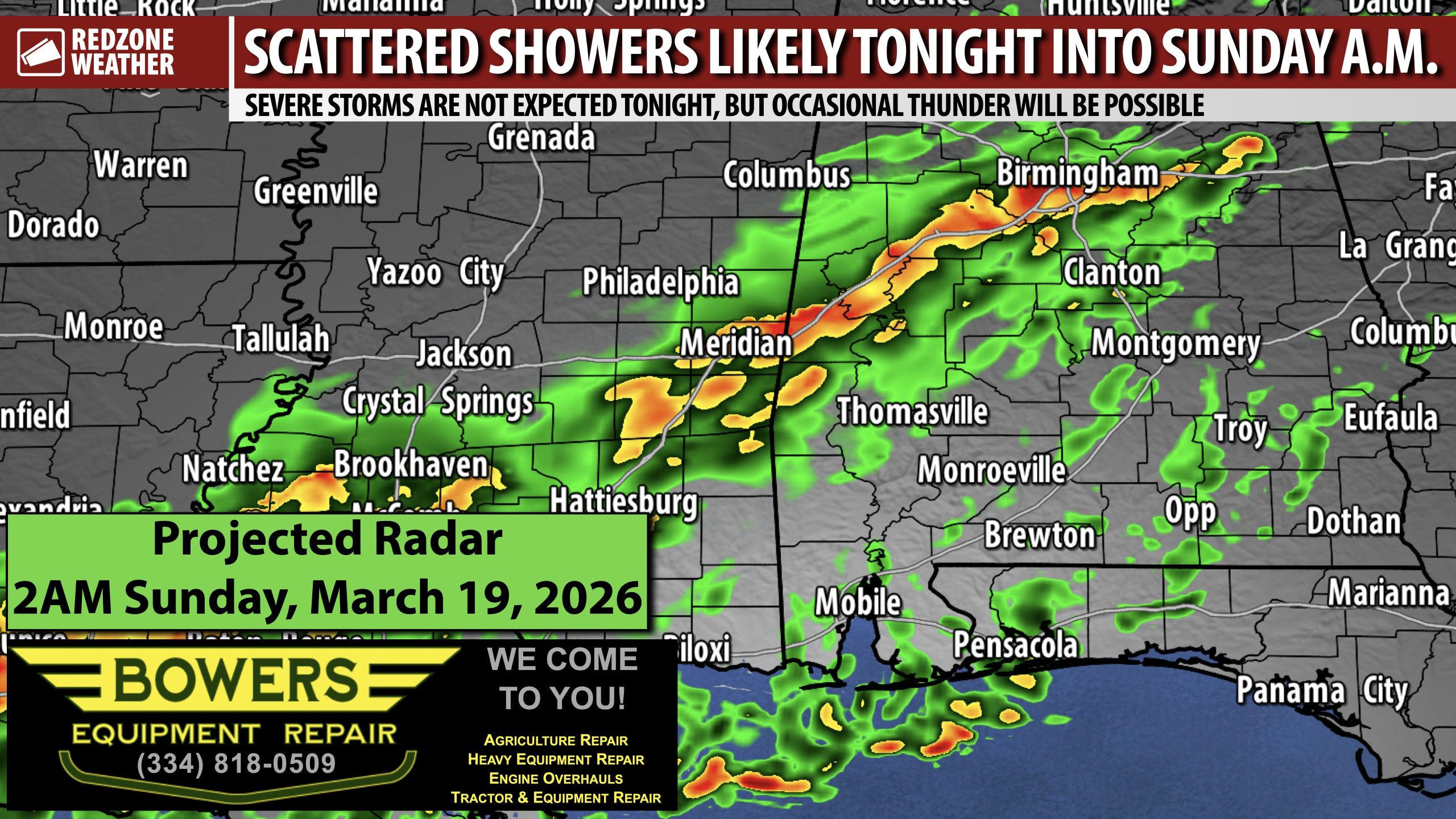
SPOTTY SHOWERS LOCALLY OVERNIGHT INTO SUNDAY… Let me lead off by saying that most communities will NOT get much rain off this event across south Alabama and northwest Florida. We’re talking rain totals of 0.1″ to 0.5″ being the norm. The greatest rain totals (0.4″ to 0.5″) will probably happen in parts of Clarke, Washington, Monroe, Wilcox, Marengo, and Choctaw counties in west Alabama. Widespread severe weather is not expected tonight or tomorrow, but a few rumbles of thunder cannot completely be ruled out.
RAIN CLEARS OUT SUNDAY AFTERNOON… Any lingering showers will move to our southeast by 2-3PM on Sunday, giving way to slightly cooler, drier air behind the advancing cold front. High temperatures on Sunday will be in the 60s inland with 70s likely for most of us across the region.
WARM & DRY MONDAY THROUGH THURSDAY… Mostly sunny skies seem likely for much of the upcoming week. High temperatures will range from near 80 degrees on Monday to the mid 80s by Thursday. Overnight lows will be in the 40s on Monday night into Tuesday with 50s likely each morning for the remainder of the week.
TENTATIVE SIGNS OF RAIN IN THE FORECAST NEXT WEEKEND… Don’t get too excited just yet but we have the best indication I have seen in a long time that we may have multiple rounds of rain and thunderstorms in 7-9 days. The data can and probably will change between now and then, but I am cautiously optimistic we will have somewhat of a pattern change that may induce higher rain chances around a week from today. It is impossible to get specific at this stage about how much rain, what communities get the most rain, will severe weather be involved, etc. Please check back with me for updates in the days ahead.
APP… If you haven’t already downloaded the RedZone Weather app, now is a great time to do that. redzoneweather.com/app is the link to the free download. Once you have the RZW app installed on your iOS or Android device, be sure to visit the Alerts tab to turn on the specific notifications you’d like to receive. All notifications are handcrafted by me. No automation and we promise not to bug you!
I will have updates posted throughout the day and into tonight, as needed, in the RedZone Weather app. My next forecast video will be posted by 7:15AM Monday morning.
Have a great weekend!
