
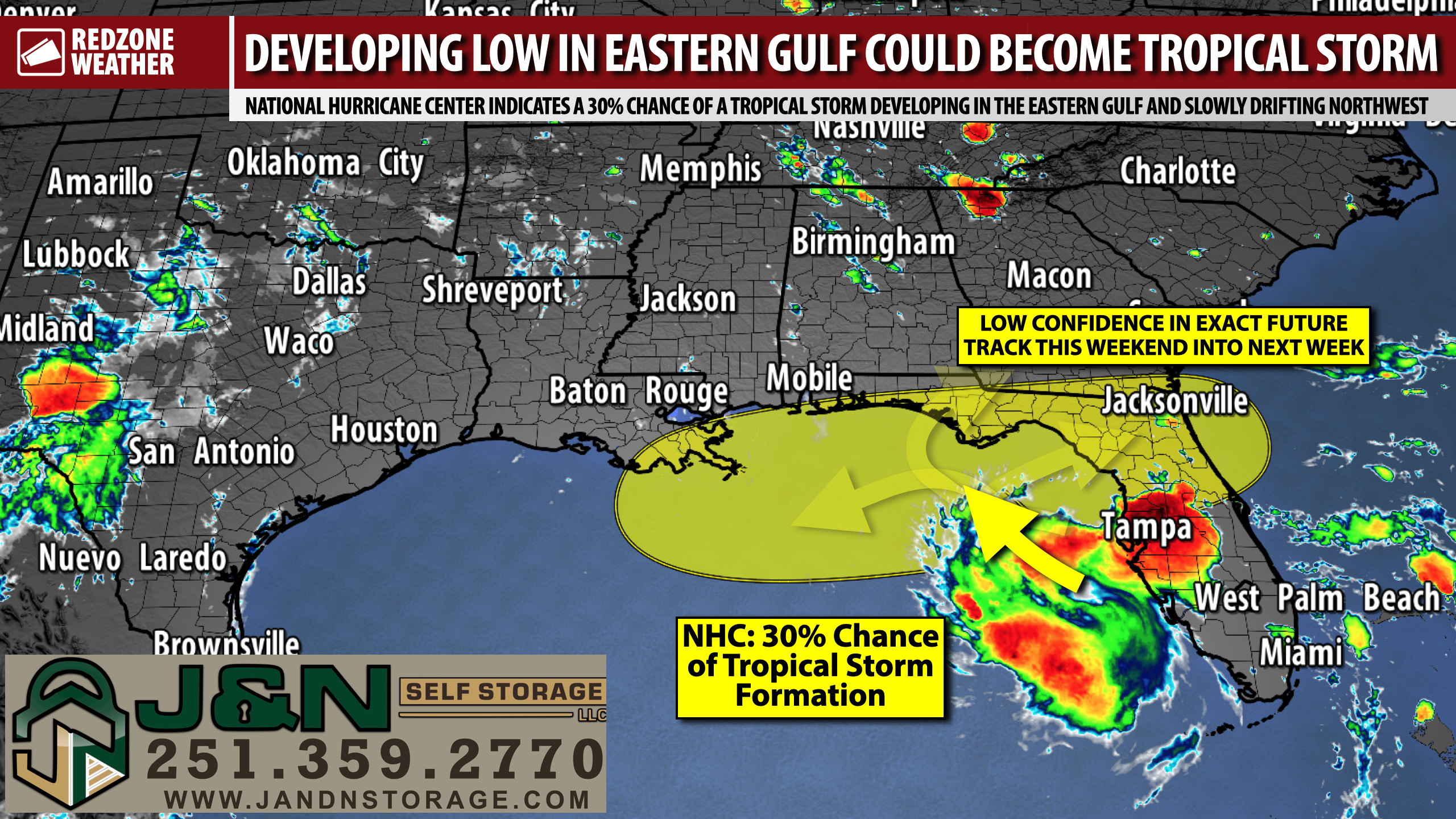
TROPICAL STORM POSSIBLE IN NORTHERN GULF IN DAYS AHEAD; BLUE ANGELS UPDATE… Chances are increasing on this Friday P.M. that we may have a tropical storm in the northern or northeastern Gulf on Sunday or into next week. The National Hurricane Center has increased development probabilities to a 30% chance in their 1PM CDT update. The area of low pressure has clearly formed this afternoon in the eastern Gulf, with the center of a broad circulation centered about 80 miles southwest of Sarasota, Florida. It remains to be seen if the low will sustain itself to actually develop into a named tropical storm at some point this weekend or into next week. Uncertainty surrounding the future of this system is very high, largely due to the fact that most of the major global weather models aren’t showing much in the way of development at this point.
BLUE ANGELS AIR SHOW FORECAST – TOMORROW… The annual Blue Angels Air Show at Pensacola Beach is scheduled to happen tomorrow afternoon. Spotty showers and thunderstorms will be possible, but it’s nearly impossible to pinpoint exactly when and where storms will pop up on a hot, humid summer day like what we are expecting tomorrow. What I can tell you with high confidence is that air temperatures will be in the low to mid 90s with heat index values in excess of 100°. Hit or miss showers and thunderstorms will be possible in the afternoon and evening hours. Be aware of this, particularly if you’re planning to be out on a boat in the bay or in the northern Gulf. There should be plenty of sunshine throughout the day in MOST spots as storms are expected to be spotty in nature. We’ll call it a 30-40% chance of storms in the P.M. hours. No need to cancel plans, just have a way to check the radar tomorrow afternoon.
GULF LOW – 30% CHANCE OF DEVELOPMENT… The setup we’re dealing with in the eastern Gulf is associated with an upper-level low and a surface trough. Model output associated with the system has been fairly consistent in suggesting IF we see a tropical storm developing late this weekend or next week, it probably would be fairly weak in nature with the biggest impact being rain across much of the Florida Peninsula. What is so striking at this hour is just how well organized the area of low pressure has become over the last few hours in the eastern Gulf. What appears to be a broad circulation located 80 miles SW of Sarasota or about 115 miles southwest of Tampa is drifting southwest in the eastern Gulf. We will need to watch how this feature evolves over the next several hours and into tonight. I suspect this is a convection flareup that will probably fade away tonight, but if the circulation and associated thunderstorms sustain into tonight, we could see a quicker development process of this system into the weekend.
POTENTIAL IMPACTS DISCUSSION – SOUTH ALABAMA AND NORTHWEST FLORIDA… As of Friday afternoon, significant, direct impacts in south Alabama and northwest Florida seem unlikely due to this system. We certainly will need to keep our eyes on the system and see how it evolves in the hours and in the days ahead as forecast changes may be possible. Please check in for updates in the days ahead! One of the biggest problems we face in the weather industry is folks locking on to an initial forecast. That can be dangerous, particularly in a setup like this where further changes are EXPECTED. I will have further updates posted in the days ahead in the RedZone Weather app.
BIG RAIN EVENT POSSIBLE IN NORTH AND CENTRAL FLORIDA… The biggest projected impacts due to this system at this point will likely be the heavy rain and flash flooding that may be possible in portions of north and central Florida over the next few days. The latest QPF (Quantitative Precipitation Forecast) showing how much rain is expected in total over the next 5 days points to upwards of 7-10” of rain being possible near Tampa with rain amounts of 3-5” being the norm along the west coast of Florida. 2-3” of rain may be possible near places like Apalachicola, Port St. Joe, Panama City, and Tyndall AFB. For now, enhanced rain chances and rain amounts seem unlikely due to this system in south Alabama and northwest Florida. This may change depending on the exact setup in the days ahead.
HIGH RISK OF RIP CURRENTS… The overall risk of dangerous rip currents is expected to increase this weekend into early next week at all beaches along the northern Gulf Coast and along the west coast of Florida in the days ahead. We lose far too many beachgoers each year to rip currents! It’s a totally preventable cause of death. Please stay out of the water at the beaches if red flags are flying.
APP… If you haven’t already downloaded the RedZone Weather app, now is a great time to do that. redzoneweather.com/app is the link to the free download. Once you have the RZW app installed on your iOS or Android device, be sure to visit the Alerts tab to turn on the specific notifications you’d like to receive. All notifications are handcrafted by me. No automation and we promise not to bug you!
I will have more updates posted this weekend in the RedZone Weather app.
Have a nice Friday evening!
