
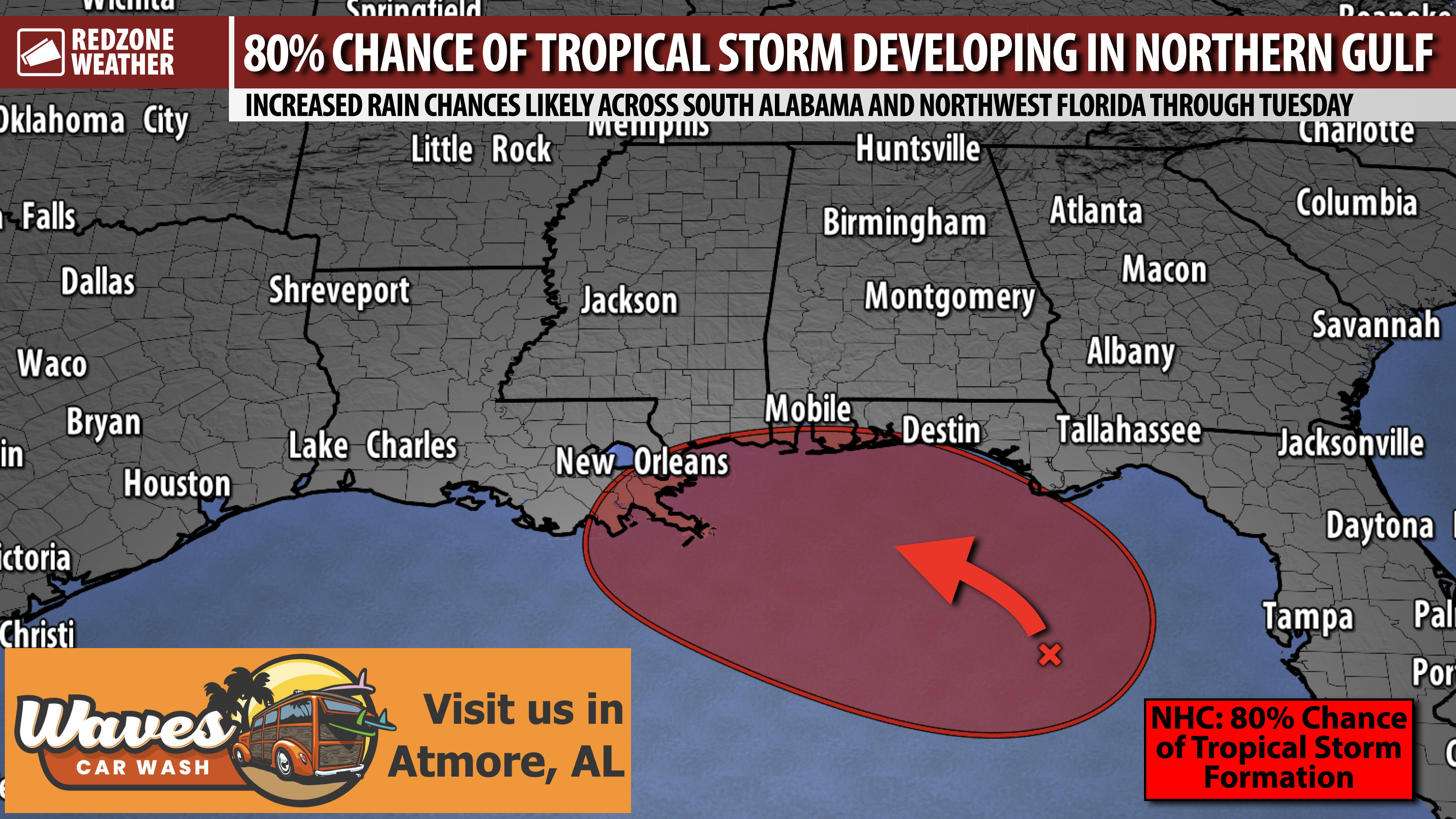
TROPICAL STORM DEVELOPMENT EXPECTED IN NORTHERN GULF… The tropical disturbance located in the northeastern Gulf continues to become better organized this morning. The National Hurricane Center indicates the system now has an 80% chance of becoming a named tropical storm over the next 48 hours, per their 7AM Sunday update. The latest guidance shows the system gradually moving northwest toward a landfall point along the northern Gulf Coast, likely in northwest Florida, Alabama, Mississippi, or Louisiana. That is a broad zone, but it is too early to be specific on where the center may come ashore. The U.S. Air Force Hurricane Hunter crew is scheduled to fly into this developing system this afternoon. Data acquired by the Hurricane Hunters will be fed into the weather models to help get a much clearer picture of the exact future track of this system.
LOCAL IMPACTS ASSESSMENT – ALABAMA & N.W. FLORIDA… Increased rain chances are expected to happen tomorrow into Tuesday and perhaps Wednesday across south Alabama and northwest Florida, particularly in areas closer to the coast, due to this system. Flash flooding could become a concern, particularly in areas closer to the coast, if storms train over the same areas. At least some risk of a few tornadoes could develop, depending on the exact future track of the system. If the center of circulation remains further offshore with a landfall point further west, the tornado risk would largely be much lower or mitigated completely across Alabama and northwest Florida. If the center is closer to the local area, a more pronounced tornado risk may develop in the days ahead. For now, significant wind impacts are highly unlikely across much of the local area.
TROPICAL STORM INTENSITY LIKELY; NOT EXPECTED TO BE A HURRICANE… I have had a few questions over the last 24 hours from folks concerned about rapid intensification. Thankfully, all of the data I have seen continues to point to this system remaining well below hurricane status. I expect the National Hurricane Center to probably declare this a Potential Tropical Cyclone this afternoon or this evening. That will allow the issuance of Tropical Storm Watches and Warnings – totally appropriate for a situation like this. Odds are extremely high the system will be a tropical storm at landfall and not a hurricane. The reason for this is because the upper atmospheric setup isn’t totally favorable for development. There will be some shear coming out of the north that helps to keep a lid on the overall intensity with this system.
SPOTTY THUNDERSTORMS EXPECTED LOCALLY TODAY… Showers and thunderstorms will be possible today across south Alabama and northwest Florida, particularly this afternoon into this evening. These storms are the daily, pop-up storms of summer, quite similar to what we saw yesterday. Rain coverage may be enhanced slightly this afternoon into this evening due to the developing tropical system to our south. I do not expect tornado issues locally today, however. Storms will be capable of producing loud thunder, cloud-to-ground lightning, and gusty winds. I will have radar updates posted this afternoon into this evening in the RedZone Weather app.
TORNADO WARNING POLICY… Any time there is an active tornado warning in effect for southwest Alabama or northwest Florida, we provide uninterrupted, live video coverage on Facebook Live and YouTube Live. Our detailed coverage commitment is outlined at redzoneweather.com/coverage. We are proud to cover all parts of Escambia (AL), Covington, Monroe, Conecuh, Baldwin, Mobile, Clarke, Washington (AL), Butler, Escambia (FL), Santa Rosa, and Okaloosa counties. If you live in any locale in those counties, be sure to tune into our coverage whenever there is an active tornado warning!
APP ALERTS… redzoneweather.com/app is the link where you can download the free RedZone Weather app. We post brief updates throughout each day in the app, keeping you up-to-date about the latest happenings in weather across south Alabama and northwest Florida. Once you have the free app downloaded to your iOS or Android device, be sure to visit the Alerts tab (lower right corner) then tap the large Alert Settings button to customize the alerts you would like to receive straight from me.
I will have more updates posted throughout the day in the RedZone Weather app.
Have a nice Sunday!
