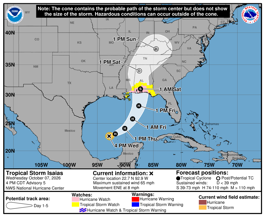
ISAIAS STRENGTHENING; PREPARE NOW FOR BIG IMPACTS BEING POSSIBLE FRIDAY NIGHT INTO SATURDAY… The warm waters of the south-central Gulf are providing fuel for Tropical Storm Isaias to continue to strengthen on this Wednesday evening. At 4PM, the National Hurricane Center indicates maximum sustained winds are now up to 65 mph. Isaias is expected to become a hurricane tonight or tomorrow. Landfall is forecast to happen on Friday night or Saturday with the most likely landfall point in Alabama or northwest Florida. The latest cone of uncertainty has shifted a bit to the east.
HURRICANE WATCH EXPANDED INLAND… A Hurricane Watch has been posted for inland areas of southwest Alabama including Escambia (AL), Covington, and Conecuh counties. These counties join Mobile, Baldwin, Escambia (FL), Santa Rosa, Okaloosa, and Walton counties in the Hurricane Watch. A Tropical Storm Watch is in effect for Washington, Clarke, Monroe, Wilcox, Butler, Coffee, Dale, Henry, Genva, and Houston counties.
HURRICANES ARE LARGE, LANDFALL POINT IS SPECIFIC… The landfall point is expected to be between Biloxi, MS and Laguna Beach, FL. That is the range of the “cone of uncertainty” at 4PM. The cone HAS shifted eastward. Further shifts of the cone remain possible. Impacts WILL extend well beyond the cone!
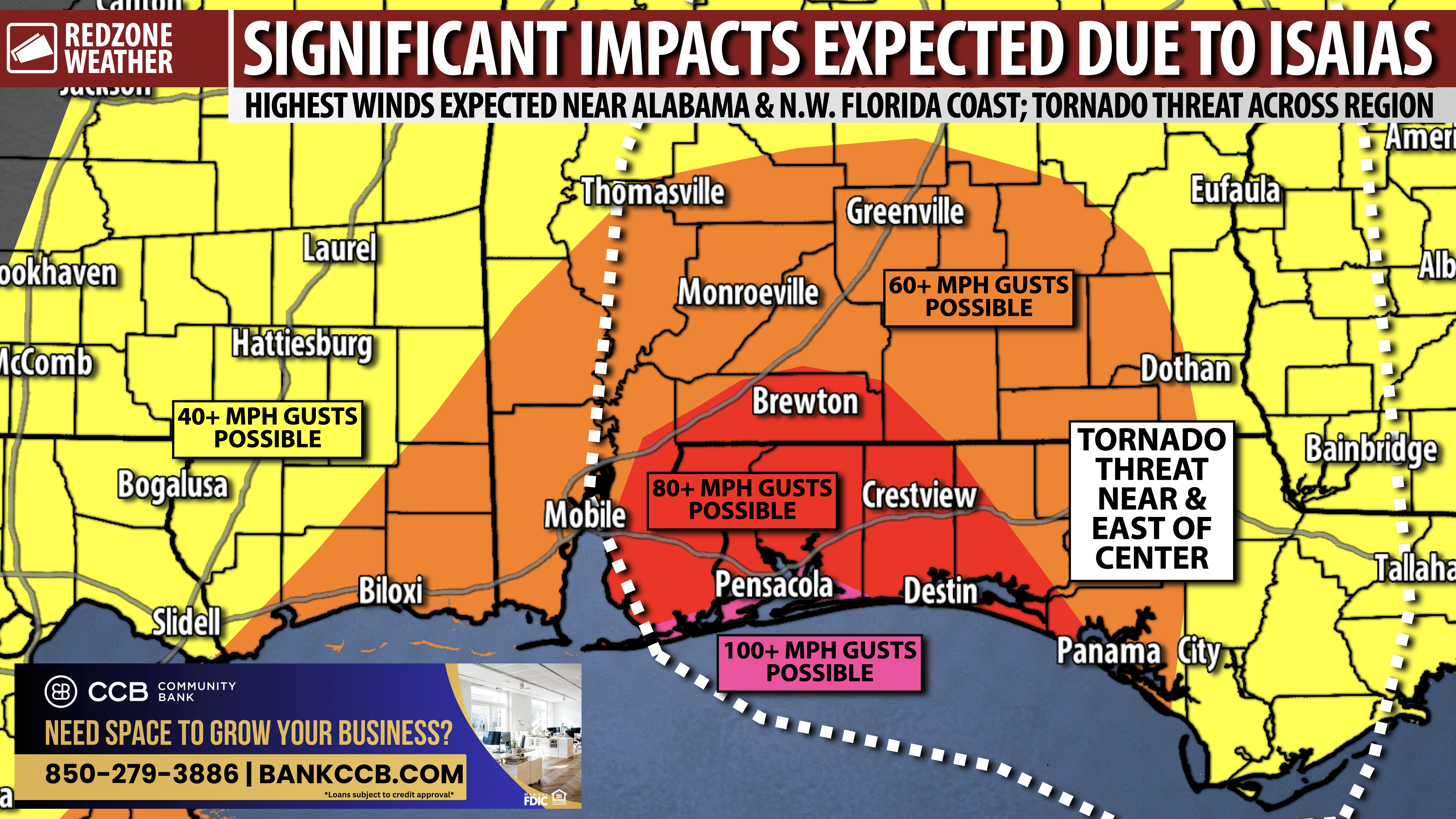
IMPACTS: DAMAGING WIND… Regardless of what happens specifically with the center of the storm, I am expecting significant impacts across a large portion of south Alabama and northwest Florida. Hurricane force winds will be possible, including widespread wind damage. This will be different than what happened with Hurricane Sally and Hurricane Zeta. Both storms caused major, but localized damage. Isaias will be much more widespread (due to the size and forward speed of the storm) and perhaps just as significant or even more significant for some communities.
IMPACTS: RAIN & FLOODING… 3 to 5 inches of total rainfall is expected across the region with isolated higher totals up to 12″ being possible where storms train over the same areas. The greatest risk of flash flooding will likely set up closer to coast but even further inland, some instances of flash flooding will be possible.
IMPACTS: STORM SURGE… Storm surge will be a problem for areas near the center of the storm AND in areas to the east of the center. This means northwest Florida and the Florida Panhandle have a high probability of potentially significant 5-8 foot storm surge with higher surge values possible. The further east we see the forecast going, the better the storm surge situation gets for Mobile Bay and the Mississippi coast, where water would be blown SOUTH (on the west side of the storm). There still may be 2 to 4 feet of storm surge in Mobile Bay, and in parts of Louisiana and Mississippi, however, the greater values will set up to the east of the center.
IMPACTS: TORNADO THREAT… Tornadoes may end up being a big deal with this hurricane, as in even more of a big deal than would normally be the case in a hurricane. We’re seeing indications that some of the tornadoes involved may be EF2+ and be on the ground for longer than a few minutes. Typically in tropical/hurricane situations, tornadoes are quick and do not last long. The tornadoes with Isaias may be more pronounced as the storm starts its extratropical transition process earlier (perhaps before or just after landfall).
THURSDAY WILL BE A NICE WEATHER DAY; LAST FULL DAY TO PREPARE AHEAD OF TD9… Tomorrow will remain dry in most communities as northeasterly winds continue bringing drier air into our region. High temperatures will be in the 83-89° range. With chances of significant impacts from what will likely be Hurricane Isaias increasing Friday, today and Thursday are the time to review your hurricane plans and take care of preparations ahead of potentially severe weather. Please keep checking the forecast as details about the system’s track and strength become more clear tonight and tomorrow.
RIP CURRENT WARNING… Rip currents kill more people than any other weather-related hazard in our local area. A HIGH risk of rip currents will continue at the Alabama and northwest Florida beaches through the remainder of the week and into the weekend. Dangerous beach conditions are already a concern, even while our weather inland remains nice. Surf will increase later this week. Stay out of the Gulf when red flags are flying!
APP… If you haven’t already downloaded the RedZone Weather app, now is a great time to do that. redzoneweather.com/app is the link to the free download. Once you have the RZW app installed on your iOS or Android device, be sure to visit the Alerts tab to turn on the specific notifications you’d like to receive. All notifications are handcrafted by me. No automation and we promise not to bug you!
More updates will be posted later. I will have updates posted in the RedZone Weather app as well.
Have a good Wednesday evening!