
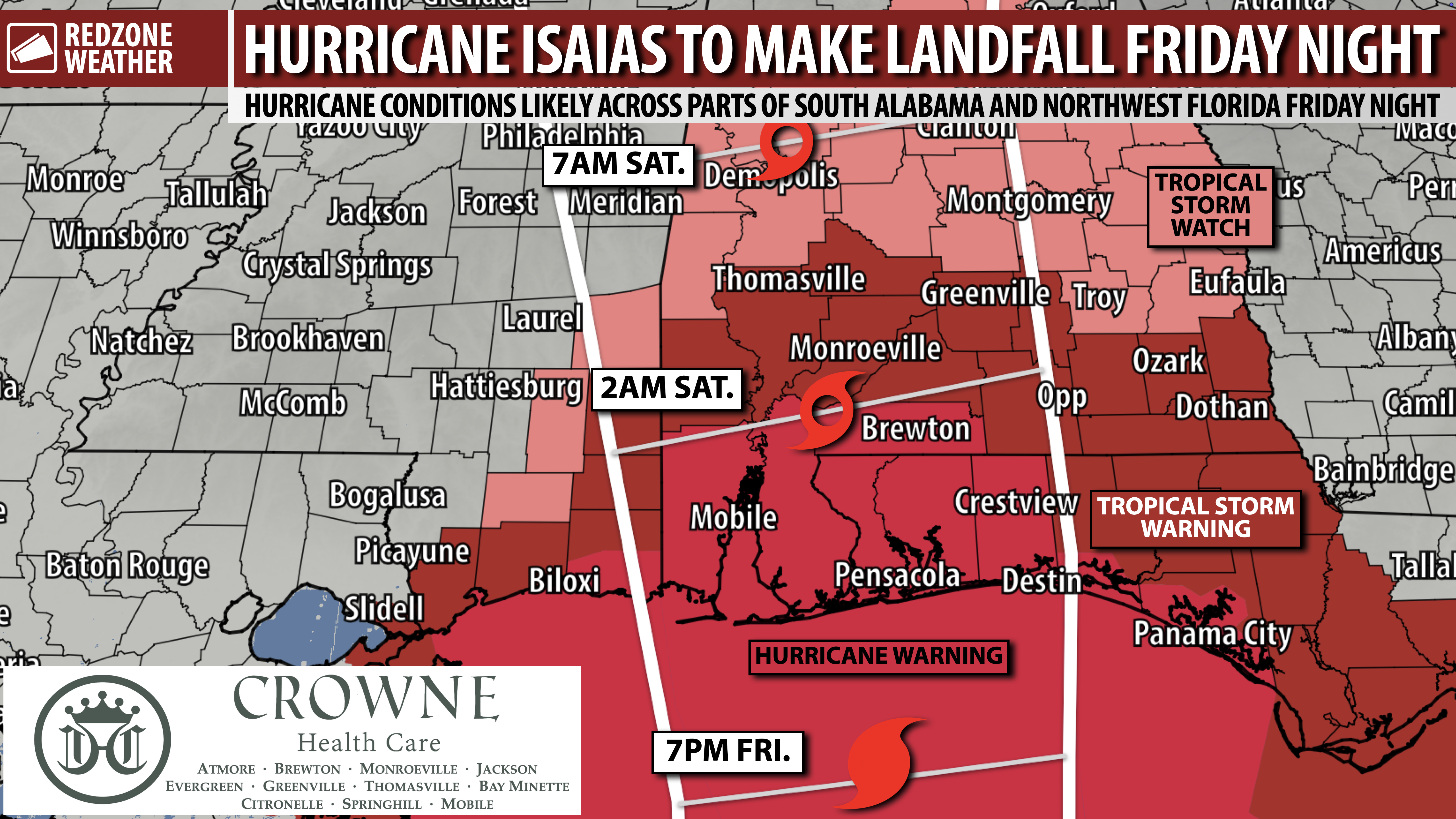
HIGH FORECAST CONFIDENCE: HURRICANE ISAIAS EXPECTED TO MAKE LANDFALL IN N.W. FLORIDA OR ALABAMA… Confidence in the forecast continues to increase that Hurricane Isaias will make landfall along the Alabama or northwest Florida coast on Friday night or early Saturday morning. The 10AM advisory from the National Hurricane Center is in: Maximum winds are up to 85 mph as gradual strengthening continues. Minimum central pressure is down to 975 millibars. The Hurricane Warning has been expanded to now include Escambia County, Alabama (further inland from the coast) due to the likelihood of sustained winds up to hurricane force in parts of that county as well. We also note that A Tropical Storm Watch has just been issued for inland stretches of Alabama, including places like Birmingham, Montgomery, Tuscaloosa, Selma, Demopolis, Auburn, Troy, and Alexander City.
FURTHER STRENGTHENING IS EXPECTED… I expect gradual strengthening of Hurricane Isaias to continue this afternoon, this evening, and into tonight. The official National Hurricane Center forecast ramps Isaias up to a 110 mph hurricane before landfall Friday night into Saturday morning.
NEW: HURRICANE WARNING EXPANDED… A Hurricane Warning continues from Ocean Springs (MS) to the Bay/Gulf County Line (FL). This includes all parts of Mobile, Baldwin, Escambia (FL), Santa Rosa, Okaloosa, Walton, and Bay counties along with Jackson County in Mississippi. Hurricane force winds are 74+ mph. Confidence is high in the potential for hurricane force wind gusts, particularly in areas NEAR and to the east of where the center of circulation of Isaias makes landfall. New today: Escambia County, Alabama has been added to the Hurricane Warning due to the likelihood of winds up to sustained hurricane force being likely.
NEW: TROPICAL STORM WARNING INLAND… A Tropical Storm Warning is in effect for several counties across the region, including Washington (AL), Clarke, Wilcox, Monroe, Conecuh, Covington, Butler, Crenshaw, Coffee, Dale, Henry, Houston, Geneva, Walton (inland), Holmes, Washington (FL), Jackson (FL), Calhoun (FL), and Gulf (FL) counties. Sustained tropical storm force winds (39+ mph) are LIKELY in these counties. A Tropical Storm Warning also is in effect for Greene and George counties in southeast Mississippi.
NEW: TROPICAL STORM WATCH FURTHER NORTH… Choctaw, Marengo, Dallas, Lowndes, Montgomery, Pike, Lee, Barbour, Macon counties and points north all the way up to Tuscaloosa and Jefferson counties are now under a Tropical Storm Watch. Tropical storm force winds will be possible all the way north to Birmingham and Tuscaloosa.
NEW: HIGH CONFIDENCE OF LANDFALL POINT… Forecast confidence is now quite high that Hurricane Isaias will make landfall somewhere between Pascagoula, Mississippi to Destin, Florida. This means that the highest probability of landfall will exist in Mobile, Baldwin, Escambia (FL), Santa Rosa, Okaloosa, or Walton counties. Worst of the impacts expected in southern Baldwin, southern Escambia (FL) – all of the Pensacola metro, southern Santa Rosa, and southern Okaloosa counties.
DAMAGING WIND EXPECTED… Regardless of what happens specifically with the center of the storm, I am expecting *significant impacts* across a large portion of south Alabama and northwest Florida. Hurricane force winds will be possible, including widespread wind damage. Wind gusts of 100+ mph will be possible in parts of southern Baldwin, southern Escambia (FL), Santa Rosa, and Okaloosa counties.
RAIN & FLOODING ISSUES… 3-5″ of rain likely across the entire region with the higher rain totals closer to the coast. Flash flooding could become a problem if storms train over the same areas. Flash flooding will be a worse problem if we get a lot of rain during the daytime hours of Friday ahead of the storm. This is a possibility.
STORM SURGE LIKELY… Storm surge will be a problem for areas near the center of the storm AND in areas to the east of the center. This means northwest Florida and the Florida Panhandle have a high probability of potentially significant 5-8 foot storm surge with higher surge values possible.
SIGNIFICANT TORNADO THREAT… Tornadoes will likely be a big deal with this hurricane, as in even more of a big deal than would normally be the case in a hurricane. We continue to see indications that some of the tornadoes involved may be EF2+ and be on the ground for longer than a few minutes. Typically in tropical/hurricane situations, tornadoes are quick and do not last long. The tornadoes with Isaias may be more pronounced as the storm starts its extratropical transition process earlier.
TORNADO WARNING POLICY… Any time there is an active tornado warning in effect for southwest Alabama or northwest Florida, we provide uninterrupted, live video coverage on Facebook Live and YouTube Live. Our detailed coverage commitment is outlined at redzoneweather.com/coverage. We are proud to cover all parts of Escambia (AL), Covington, Monroe, Conecuh, Baldwin, Mobile, Clarke, Washington (AL), Butler, Escambia (FL), Santa Rosa, and Okaloosa counties. If you live in any locale in those counties, be sure to tune into our coverage whenever there is an active tornado warning!
APP ALERTS… redzoneweather.com/app is the link where you can download the free RedZone Weather app. We post brief updates throughout each day in the app, keeping you up-to-date about the latest happenings in weather across south Alabama and northwest Florida. Once you have the free app downloaded to your iOS or Android device, be sure to visit the Alerts tab (lower right corner) then tap the large Alert Settings button to customize the alerts you would like to receive straight from me.
APP… If you haven’t already downloaded the RedZone Weather app, now is a great time to do that. redzoneweather.com/app is the link to the free download. Once you have the RZW app installed on your iOS or Android device, be sure to visit the Alerts tab to turn on the specific notifications you’d like to receive. All notifications are handcrafted by me. No automation and we promise not to bug you!
NEXT UPDATE… I will have another highly detailed update posted around 4:30PM. More updates will be posted in the RedZone Weather app over the next few hours.
Have a nice Thursday afternoon! Get those hurricane preparations DONE!
