
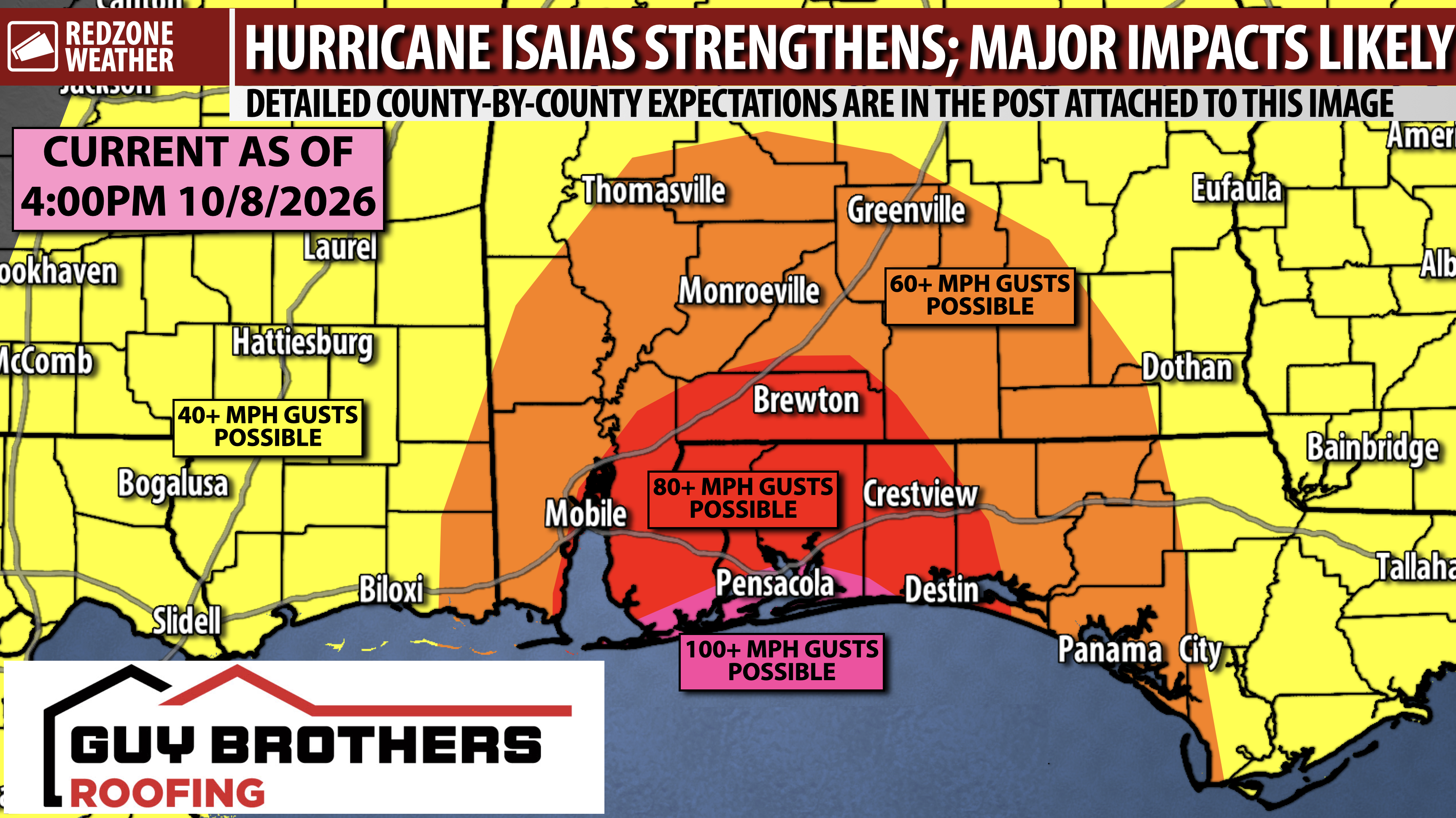
HIGHLY DETAILED COUNTY-BY-COUNTY ASSESSMENT: HURRICANE ISAIAS STRENGTHENING… Hurricane Isaias now has maximum winds of 100 mph, making the storm a category 2 hurricane. Further strengthening is expected. You will find a highly detailed assessment below as to what you can expect in each of our local counties due to Hurricane Isaias, which is expected to have maximum winds between 100-120 mph tomorrow (Friday) at landfall in northwest Florida or coastal Alabama. Isaias will then rapidly move north into our far inland areas likely as a strong tropical storm. Keep in mind that impacts WILL extend well away from the center landfall point AND much of our area will be on the volatile eastern flank of this rapidly-moving storm. Local impacts from Isaias will be most pronounced Friday night into early Saturday morning.
To be clear: This will be a direct hit on our local area from a hurricane that likely brings significant impacts to a wide area.
STORM AWARENESS IS KEY… If you’re reading this far into this post, odds are you’re a bit more “weather aware” than most of your friends and family members. Please help me get the word out about potential local impacts by passing this along to your folks.
4PM UPDATE FROM NHC… Maximum winds near the center of Hurricane Isaias are near 100 mph, per the latest reports from the U.S. Air Force Hurricane Hunters recon tram. Isaias is moving northeast at 12 mph. Forward speed will likely increase somewhat ahead of landfall. Minimum central pressure is at 975 millibars.
LOCAL ISAIAS IMPACTS MOST LIKELY FRIDAY NIGHT… The time frame for significant local impacts in south Alabama and northwest Florida from Hurricane Isaias will happen from 4PM on Friday to Noon on Saturday with the GREATEST threat being from 9PM Friday to 9AM Saturday.
TROPICAL STORM FORCE WINDS: START TIME… Tropical storm force winds may be possible at the coast as soon as tomorrow afternoon. By 4-5PM, tropical storm force winds will LIKELY be moving into coastal zones. Tropical storm force winds will spread inland through 8-9PM. I would suggest getting where you are going to get for the hurricane by 5PM if you can or as soon after 5PM as possible.
TORNADO RISK AT THE COAST STARTS FRIDAY; SPREADS INLAND FRIDAY NIGHT… Tornadoes will be possible in the outer rain bands of Isaias that spread across south Alabama and northwest Florida on Friday evening. The tornado risk will continue into Saturday morning. The tornado risk will likely start first around the Alabama and northwest Florida coastline and gradually spread eastward and inland throughout the night on Friday night into early Saturday. Tropical tornadoes generally do not last long, but we note that some of the tornadoes in this hurricane may last a bit longer and be on the ground for longer. If we have tornado warnings at any point over the next few days, be sure to join us in our live video coverage. redzoneweather.com/coverage outlines our tornado warning coverage commitment in great detail. The Storm Prediction Center has included basically all of our local area in their Level 2 (out of 5) tornado risk zone.
Below are the detailed county-by-county assessments discussing what you can expect from Hurricane Isaias, which is expected to have maximum sustained winds of 100 – 120 mph at landfall Friday night.
ESCAMBIA COUNTY, FL… A Hurricane Warning is in effect. There is a high potential for numerous downed trees and power lines. Numerous power outages will be likely. Maximum sustained winds are expected to be in the 60-80 mph range near Century, Molino, Bratt, and Walnut Hill. Maximum sustained winds near Pensacola, Cantonment, Beulah, Perdido Key, and southern Escambia County (FL) will be in the 90-110 mph range. A significant storm surge of 5 to 8+ feet will be possible at the beaches and bays. Total rain amounts of 3-5″ are expected, meaning flash flooding will be a concern. Strong tornadoes will be possible.
Locations: Pensacola, Pensacola Beach, Perdido Key, Warrington, Myrtle Grove, Molino, Walnut Hill, Bratt, Century, Ensley, Gonzalez, Cantonment, Quintette, McDavid.
SANTA ROSA COUNTY, FL… A Hurricane Warning is in effect. There is a high potential for numerous downed trees and power lines. Numerous power outages will be likely. Maximum sustained winds are expected to be in the 60-80 mph range near Jay, Berrydale, Chumuckla, Brownsdale, and Munson. Maximum sustained winds near Milton, Pace, Whiting Field, and Harold are expected to be in the 70-90 mph range. Maximum sustained winds near Gulf Breeze, Tiger Point, Midway (FL), Navarre, Navarre Beach, Holley, Garcon Point, and southern Santa Rosa County (FL) will be in the 90-110 mph range. A significant storm surge of 5 to 8+ feet will be possible at the beaches and bays. Total rain amounts of 3-5″ are expected, meaning flash flooding will be a concern. Strong tornadoes will be possible.
Locations: Navarre, Jay, Milton, Pace, Gulf Breeze, Harold, Whiting Field, Chumuckla, New York, Brownsdale, Berrydale, Munson, Fidelis, McClellan, Mulat, Bagdad, Pine Bluff, Avalon Beach, Garcon Point, Whitfield, Allentown.
OKALOOSA COUNTY, FL… A Hurricane Warning is in effect. There is a high potential for numerous downed trees and power lines. Numerous power outages will be likely. Maximum sustained winds are expected to be in the 60-80 mph range near Crestview, Baker, Laurel Hill, and Holt. Maximum sustained winds near Destin, Fort Walton Beach, Eglin AFB, Niceville, and southern Okaloosa County (FL) will be in the 80-100 mph range. A significant storm surge of 5 to 8+ feet will be possible at the beaches and bays. Total rain amounts of 3-5″ are expected, meaning flash flooding will be a concern. Strong tornadoes will be possible.
Locations: Destin, Fort Walton Beach, Niceville, Mary Esther, Wright, VPS, Eglin AFB, Crestview, Deerland, Campton, Auburn (FL), Baker, Holt, Milligan, Laurel Hill.
WALTON COUNTY, FL… A Hurricane Warning is in effect for communities closer to the beaches and Choctawhatchee Bay with a Tropical Storm Warning in effect for DeFuniak Springs and inland communities. There is a high potential for numerous downed trees and power lines. Scattered to numerous power outages will be likely. Maximum sustained winds are expected to be in the 60-80 mph range near DeFuniak Springs, Mossy Head, and Paxton. Maximum sustained winds near Miramar Beach, Santa Rosa Beach, Seaside, and southern Walton County (FL) will be in the 70-90 mph range. A significant storm surge of 5 to 8+ feet will be possible at the beaches and bays. Total rain amounts of 3-5″ are expected, meaning flash flooding will be a concern. Strong tornadoes will be possible.
Locations: DeFuniak Springs, Freeport, Mossy Head, Red Bay, Bruce, Darlington, Eucheanna, Glendale, Liberty, Villa Tasso, Paxton, Alys Beach, Blue Mountain Beach, Dune Allen, Grayton Beach, Gulf Place, Inlet Beach, Miramar Beach, Rosemary Beach, Sandestin, Santa Rosa Beach, Seacrest, Seagrove, Seascape, Seaside, Watercolor, Watersound.
MOBILE COUNTY, AL… A Hurricane Warning is in effect for the entire county. There is a potential for numerous downed trees and power lines, particularly if the center of Isaias ends up moving a bit further west. Scattered to numerous power outages will be possible. Maximum sustained winds are expected to be in the 50-70 mph range with higher wind gusts being possible at the immediate coastline of Dauphin Island and along Mobile Bay and the Mississippi Sound. Total rain amounts of 4-6″ are expected, meaning flash flooding will be a concern. Tornadoes will be possible, particularly if the center of the storm ends up being a bit closer to Mobile County. 2 to 4 feet of storm surge is currently projected for Dauphin Island and the southern coastline of Mobile Bay near Bayou La Batre with 3 to 5 feet of storm surge projected for areas along Mobile Bay, however if the center of Isaias is a bit further west, a storm surge of 5 to 8 feet would be likely.
Locations: Mobile, Prichard, Citronelle, Mt. Vernon, Creola, Satsuma, Saraland, Calvert, Wilmer, West Mobile, Bayou La Batre, Coden, Alabama Port, Dauphin Island, Theodore, Crichton, Tanner Williams, Tillmans Corner, Chunchula, Grand Bay.
BALDWIN COUNTY, AL… A Hurricane Warning is in effect for the entire county. There is a potential for numerous downed trees and power lines. Numerous power outages are likely. Maximum sustained winds are expected to be in the 70-90 mph range with higher wind gusts of 100-120 mph being possible at the immediate coastline of Fort Morgan, Gulf Shores, and Orange Beach. Total rain amounts of 4-6″ are expected, meaning flash flooding will be a concern. Tornadoes will be possible. 2 to 4 feet of storm surge will be possible along the Eastern Shore of Mobile Bay, depending on the exact track of Isaias. 5 to 8 feet of storm surge will also be possible along the coastline near Fort Morgan, Gulf Shores, and Orange Beach.
Locations: Daphne, Fairhope, Spanish Fort, Gulf Shores, Orange Beach, Fort Morgan, Magnolia Springs, Foley, Elberta, Elsanor, Robertsdale, Summerdale, Silverhill, Montrose, Loxley, Stapleton, Bay Minette, Stockton, Rabun, Perdido, Tensaw, Point Clear.
WASHINGTON COUNTY, AL… A Tropical Storm Warning is in effect. There is a potential for scattered downed trees and power lines. Scattered power outages will be possible. Maximum sustained winds are expected to be in the 40-60 mph range with higher wind gusts being possible. Total rain amounts of 3-5″ are expected, meaning flash flooding will be a concern. Tornadoes are less likely on the western side of the storm.
Locations: Chatom, Leroy, McIntosh, Millry, Deer Park, Vinegar Bend, Fruitdale, Yellow Pine, Copeland, Yarbo, Jordan, Bigbee, St. Stephens, Tibbie, Sims Chapel, Sunflower, Malcolm.
CLARKE COUNTY, AL… A Tropical Storm Warning is in effect. There is a potential for scattered downed trees and power lines. Scattered power outages will be possible. Maximum sustained winds are expected to be in the 40-60 mph range with higher wind gusts being possible. Total rain amounts of 3-5″ are expected, meaning flash flooding will be a concern. Tornadoes will be possible.
Locations: Thomasville, Grove Hill, Jackson, Coffeeville, Fulton, Carlton, Gainestown, Gosport, Whatley, Scyrene, Springfield, Chilton, Tallahatta Springs, Bashi, Woods Bluff, Campbell, Zimco, Toddtown, Salitpa, Suggsville, Alma, Dickinson, West Bend, Winn, Walker Springs.
MONROE COUNTY, AL… A Tropical Storm Warning is in effect. There is a potential for scattered downed trees and power lines. Scattered to numerous power outages will be possible. Maximum sustained winds are expected to be in the 50-70 mph range with higher wind gusts being possible. Total rain amounts of 3-5″ are expected, meaning flash flooding will be a concern. Strong tornadoes will be possible.
Locations: Monroeville, Excel, Uriah, Frisco City, Megargel, Mineola, Chrysler, Goodway, Peterman, Tunnel Springs, Beatrice, Riley Crossing, Perdue Hill, Mexia, Scratch Ankle, Hybart, Franklin, Eliska.
CONECUH COUNTY, AL… A Tropical Storm Warning and a Hurricane Watch are in effect. There is a potential for scattered to numerous downed trees and power lines. Numerous power outages will be possible. Maximum sustained winds are expected to be in the 50-70 mph range with higher wind gusts being possible. Total rain amounts of 3-5″ are expected, meaning flash flooding will be a concern. Strong tornadoes will be possible.
Locations: Evergreen, Castleberry, Owassa, Repton, Lenox, Range, Burnt Corn, Lyeffion, Centerville, Johnsonville, Brooklyn, Paul, Melrose, Old Sparta, Jay Villa, Belleville.
ESCAMBIA COUNTY, AL… A Hurricane Warning is in effect. There is a potential for scattered to numerous downed trees and power lines. Numerous power outages will be possible. Maximum sustained winds are expected to be in the 60-80 mph range with higher wind gusts being possible. Total rain amounts of 3-5″ are expected, meaning flash flooding will be a concern. Strong tornadoes will be possible.
Locations: Brewton, East Brewton, Atmore, Flomaton, Riverview, Poarch, Huxford, Wallace, Barnett Crossroads, Pineview, Wawbeek, Canoe, Nokomis, Appleton, Kirkland, Dixie, Roberts, Damascus, Pollard/McCall.
BUTLER COUNTY, AL… A Tropical Storm Warning is in effect. There is a potential for scattered downed trees and power lines. Scattered power outages will be possible. Maximum sustained winds are expected to be in the 40-60 mph range with higher wind gusts being possible. Total rain amounts of 3-5″ are expected, meaning flash flooding will be a concern. Strong tornadoes will be possible.
Locations: Greenville, Georgiana, Chapman, Bolling, Grace, Garland, Oaky Streak, Daisy, Halso Mill, Starlington, Forest Home.
WILCOX COUNTY, AL… A Tropical Storm Warning is in effect. There is a potential for scattered downed trees and power lines. Scattered power outages will be possible. Maximum sustained winds are expected to be in the 40-60 mph range with higher wind gusts being possible. Total rain amounts of 3-5″ are expected, meaning flash flooding will be a concern. Strong tornadoes will be possible.
Locations: Camden, Pine Hill, Yellow Bluff, Millers Ferry, McWilliams, Oak Hill, Coy, Lower Peach Tree.
COVINGTON COUNTY, AL… A Tropical Storm Warning and a Hurricane Watch are in effect. There is a potential for scattered to numerous downed trees and power lines. Numerous power outages will be possible. Maximum sustained winds are expected to be in the 50-70 mph range with higher wind gusts being possible. Total rain amounts of 3-5″ are expected, meaning flash flooding will be a concern. Strong tornadoes will be possible.
Locations: Andalusia, Opp, Florala, Rose Hill, Onycha, Red Oak, Green Bay, Straughn, Red Level, Gantt, Clearview, Carolina, Pleasant Home, Wing, Sanford, Libertyville, Eoda, Horn Hill, Lockhart, River Falls, Loango, Fairfield.
BAY, WASHINGTON (FL), HOLMES COUNTIES… A Hurricane Warning is in effect for coastal parts of Bay County, including Panama City. A Tropical Storm Warning is in effect for Bay County (inland), Holmes and Washington (FL) counties. There is a potential for scattered to numerous downed trees and power lines. Scattered to numerous power outages will be possible. Maximum sustained winds are expected to be in the 50-70 mph range with higher wind gusts being possible. Total rain amounts of 3-5″ are expected, meaning flash flooding will be a concern. Strong tornadoes will be possible.
CRENSHAW, HENRY, HOUSTON, GENEVA, DALE, COFFEE COUNTIES… All six Southeast Alabama counties are under a Tropical Storm Warning. There is a potential for scattered to numerous downed trees and power lines, particularly in Coffee and Geneva counties. Maximum sustained winds are expected to be in the 40-60 mph range with higher wind gusts being possible. Total rain amounts of 3-5″ are expected, meaning flash flooding will be a concern. Strong tornadoes will be possible.
GREENE, GEORGE, WAYNE COUNTIES IN MISSISSIPPI… A Tropical Storm Warning is in effect for Greene and George counties with a Tropical Storm Watch in place for Wayne County. There is a potential for scattered downed trees and power lines. Maximum sustained winds are expected to be in the 30-50 mph range with higher wind gusts being possible. Total rain amounts of 3-5″ are expected, meaning flash flooding will be a concern. The bigger impacts will likely happen to the east of these counties in parts of Alabama and Florida.
TROPICAL STORM WATCH FOR CENTRAL ALABAMA COUNTIES… Several counties across central Alabama are now involved in a Tropical Storm Watch as there is a chance of tropical storm force winds in parts of central and north Alabama. This Tropical Storm Watch is in effect for all parts of Choctaw, Marengo, Dallas, Lowndes, Montgomery, Lee, Pike, Barbour, Russell counties and points north in central Alabama. The Tropical Storm Watch includes Birmingham, Tuscaloosa, Auburn, Alexander City, Clanton, Selma, Livingston, and many more communities in central Alabama.
TORNADO WARNING POLICY… Any time there is an active tornado warning in effect for southwest Alabama or northwest Florida, we provide uninterrupted, live video coverage on Facebook Live and in the RedZone Weather app. Our detailed coverage commitment is outlined at redzoneweather.com/coverage. We are proud to cover all parts of Escambia (AL), Covington, Monroe, Conecuh, Baldwin, Mobile, Clarke, Washington, Butler, Escambia (FL), Santa Rosa, and Okaloosa counties. If you live in any locale in those counties, be sure to tune into our coverage whenever there is an active tornado warning!
SET UP APP ALERTS… Many updates will be posted throughout the day in the RedZone Weather app. redzoneweather.com/app is the link for the free download. Be sure to visit the Alerts tab (bottom right corner) and tap the large, yellow “Alert Settings” button to customize the alerts you’d like to receive from me. If you like a lot of info, be sure to toggle ON Low-Level Alerts.
NEXT UPDATE… I will have another detailed LIVE video update this evening starting at some point between 7PM and 9PM. Until then, we will have plenty of rolling updates being posted in the RedZone Weather app. Have a nice Thursday. Rush hurricane preparation to completion!
Stay safe during the storm!
