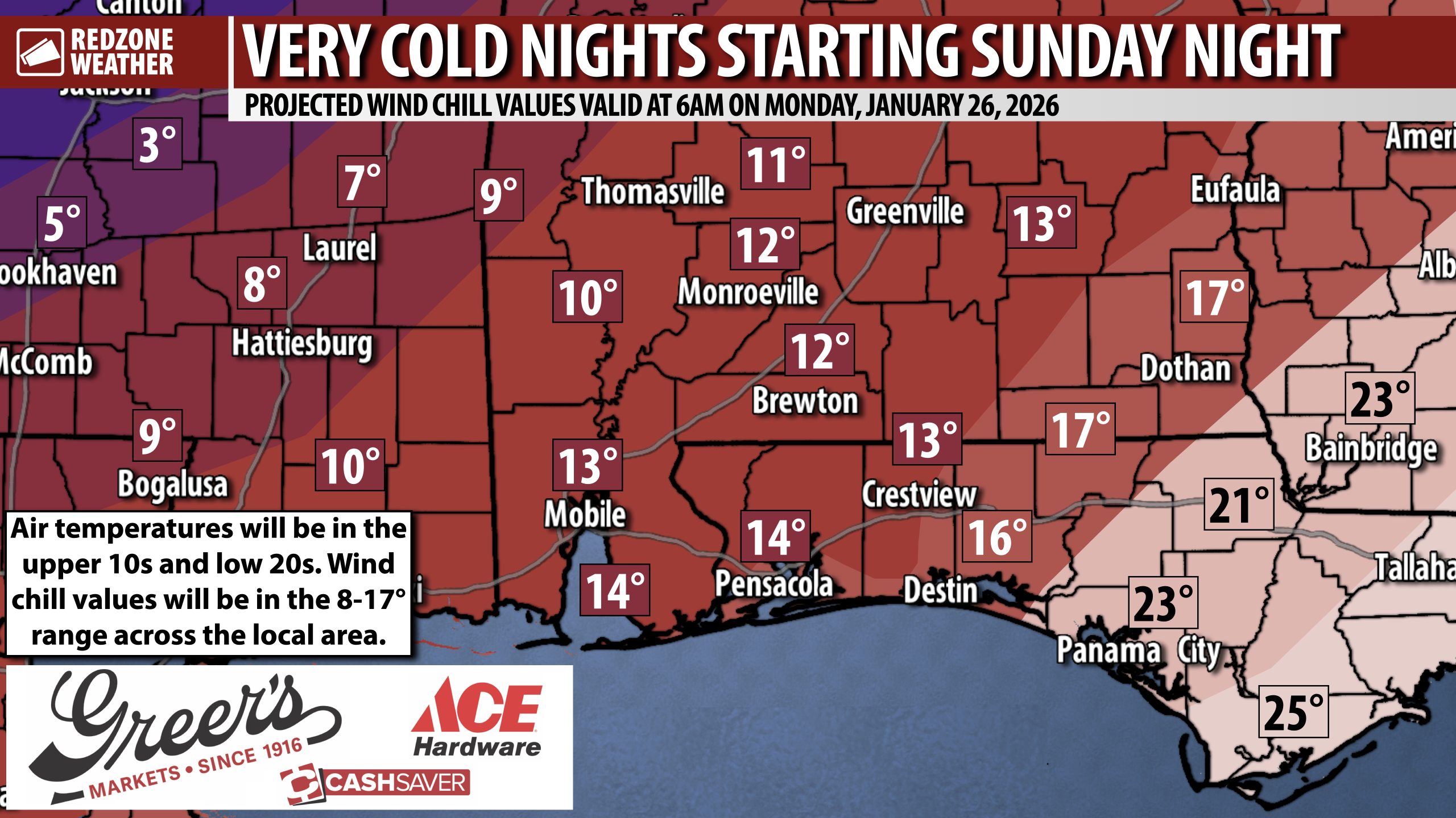
EXTREME COLD WATCH SUN. NIGHT INTO MONDAY MORNING; AIR TEMPS IN 10s AND LOW 20s… Very cold air will surge into the Deep South early next week. Wind chill values will likely be in the single digits early Monday morning across inland areas of southwest Alabama with 10s likely as far south as the beaches. Air temperatures will dip into the upper 10s inland and into the low 20s as far south as I-10 and the coast on Sunday night and again on Monday night. We’re entering into what will be a lengthy cold period starting Sunday night. Before we get there, a dangerous ice storm will happen to our north. We have a low-end tornado risk setting up for Sunday as well.
WHAT TO EXPECT – SATURDAY INTO SATURDAY NIGHT… Spotty rain showers will be possible across south Alabama and northwest Florida on Saturday. Rain chances will increase Saturday evening. Sleet and freezing rain will be ongoing tomorrow across parts of north Mississippi, north Alabama, Tennessee, Arkansas, and north Louisiana. Travel to those regions is strongly discouraged starting tomorrow. If you travel to those places, please be aware you very well may not be able to get back for several days due to treacherous road conditions due to accumulating ice. I am not expecting freezing rain across south Alabama or northwest Florida on Saturday, just spotty showers at times.
SEVERE WEATHER TIMING – SUNDAY… 11AM to 8PM Sunday is the nine hour window when isolated strong to severe thunderstorms may become possible across south Alabama and northwest Florida with the core window being from Noon to 6PM.
WHAT TO EXPECT – SUNDAY THRU SUNDAY EVENING… Rain at times. Thunderstorms are likely. A few, brief, isolated severe storms may happen. Any storms that become strong will be capable of producing damaging wind gusts and perhaps a tornado or two. The severe weather risk remains at the lowest category (Level 1 out of 5), thus widespread severe storms remain unlikely. MOST communities will simply have rain at times.
ICE STORM WARNING TO OUR NORTH… Much of northern Louisiana, north Mississippi, northwest Alabama, southern Tennessee, north Georgia, South Carolina, and North Carolina are involved in a rare Ice Storm Warning. MAJOR impacts, including widespread and long-lasting power outages are expected in these zones this weekend. Road travel will become nearly impossible where significant ice accretion happens. Just to the north of the zones mentioned, heavy snow is likely. Travel to these zones is STRONGLY discouraged this weekend into early next week. I would imagine air travel across the nation will be severely crippled due to major ice issues affecting Atlanta, Houston, Dallas, Charlotte, D.C., New York, and other major airports. This will be the most significant and widespread winter storm the nation has had in at least 10-15 years.
PATCHY BLACK ICE MAY BECOME POSSIBLE SUNDAY NIGHT… Cold, dry air will rapidly move into south Alabama and northwest Florida Sunday night into Monday morning. We may have patchy areas of black ice becoming possible on local roadways overnight Sunday into early Monday morning, particularly on bridges and overpasses. Black ice is a thin, nearly invisible layer of transparent ice that forms on roadways, sidewalks, and other surfaces, creating extremely hazardous, low-friction conditions for drivers and pedestrians. Despite its name, it is not actually black; it appears as such because it is so thin and clear that the dark pavement beneath it shows through. It is considered one of the deadliest hazards of winter because it is difficult to spot until it is too late, often appearing as just a wet spot on the road.
WAY TOO EARLY TO DISCUSS NEXT WEEKEND… There is no way to predict with any type of accuracy whether a winter storm will set up across parts of the Deep South in 7-10 days. Social media has been a dumpster fire with raw model data circulating suggesting 6+ inches of snow next weekend in our local area. As I have cautioned time and time again over the last few days, the skill to forecast snow simply does not exist across the Deep South more than 2-3 days out. This is a classic situation where the American-based GFS has been extremely aggressive, showing a major snow storm locally. The ECMWF/Euro, however, quite seriously shows sunshine and mild temperatures. Both models have performed extremely poorly over the last few days ahead of the big ice storm issues to our north. For now, we wait for more data. Model data was never designed to be shared on social media in single run images. It’s like looking at a raw egg (one ingredient) and calling it a pound cake (a finished and refined forecast).
TORNADO WARNING POLICY… Any time there is an active tornado warning in effect for southwest Alabama or northwest Florida, we provide uninterrupted, live video coverage on Facebook Live and YouTube Live. Our detailed coverage commitment is outlined at redzoneweather.com/coverage. We are proud to cover all parts of Escambia (AL), Covington, Monroe, Conecuh, Baldwin, Mobile, Clarke, Washington (AL), Butler, Escambia (FL), Santa Rosa, and Okaloosa counties. If you live in any locale in those counties, be sure to tune into our coverage whenever there is an active tornado warning!
APP ALERTS… redzoneweather.com/app is the link where you can download the free RedZone Weather app. We post brief updates throughout each day in the app, keeping you up-to-date about the latest happenings in weather across south Alabama and northwest Florida. Once you have the free app downloaded to your iOS or Android device, be sure to visit the Alerts tab (lower right corner) then tap the large Alert Settings button to customize the alerts you would like to receive straight from me.
NEXT UPDATES… I will have more updates posted on Saturday, as needed, in the RedZone Weather app. I will have another update posted on Facebook by 7:15AM.
Have a wonderful Friday evening!
