
1:00PM October 5, 2026
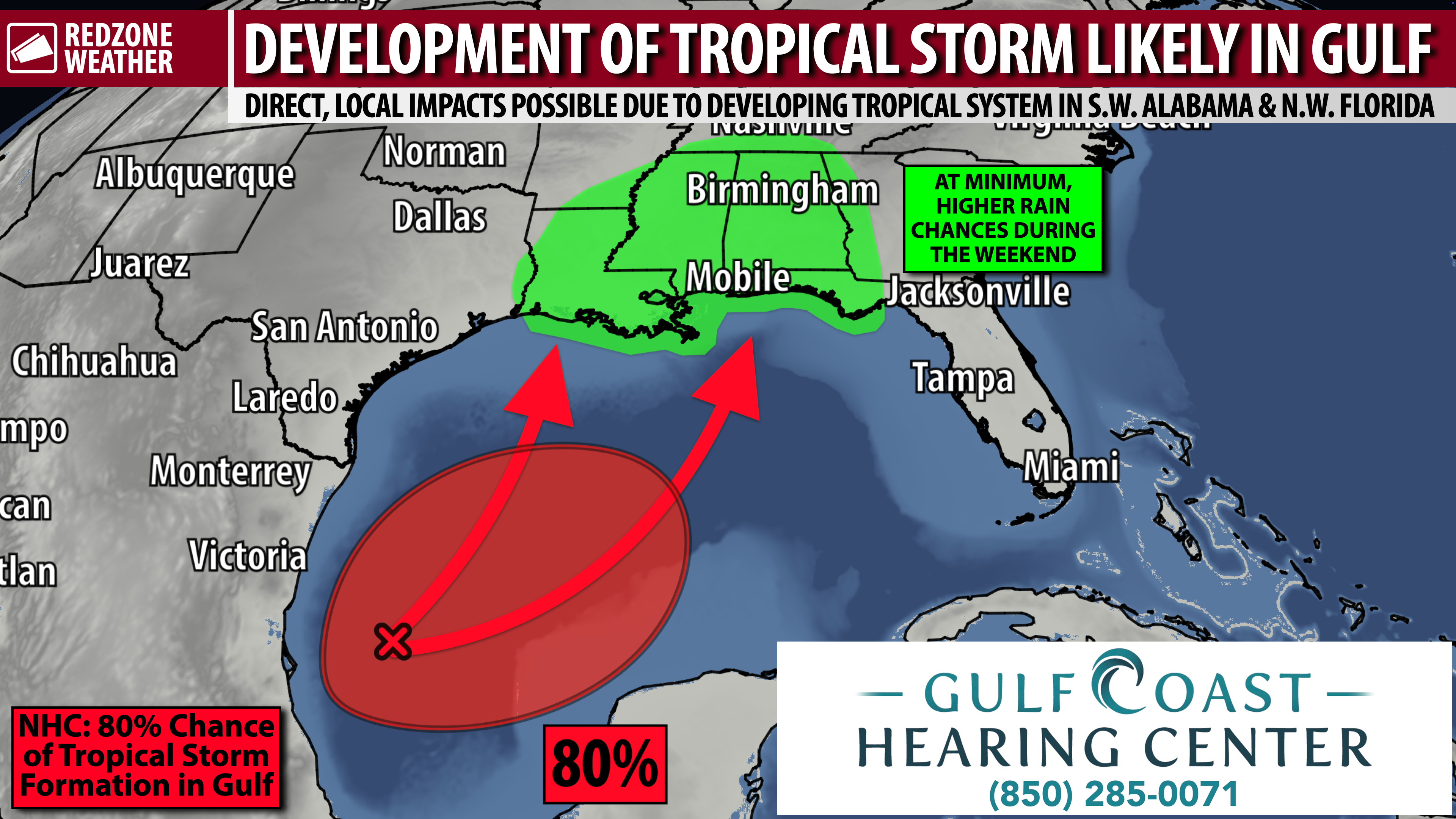
TROPICAL STORM LIKELY TO FORM IN S.W. GULF LATER THIS WEEK; LOCAL IMPACTS POSSIBLE… Chances of a tropical storm developing in the southwestern Gulf continue to rise on this Monday. The National Hurricane Center says there is an 80% chance of a tropical storm developing this week in the Bay of Campeche region of the Gulf. Guidance indicates the system, whether or not it becomes a named tropical storm, will move toward the northern Gulf Coast this weekend, bringing with it heavy rain at times. IF the system becomes a tropical storm or hurricane, significant local impacts may become possible across south Alabama and northwest Florida. It’s too early to know specific impacts for specific locations, but below is some general guidance as to what we are looking at as of 1PM Monday. PLEASE check back in for updates in the days ahead as forecast changes are LIKELY.
POTENTIAL LOCAL IMPACTS – ALABAMA & N.W. FLORIDA… Since we are still 4-5 days out from potential impacts due to this tropical system, it’s important for me to stress that CHANGES will be likely in the days ahead. The storm hasn’t even formed yet, so it’s impossible to nail down what to expect for specific communities just yet. Let’s break this down into what is likely, what is possible, and what (at the moment, anyway) seems unlikely.
LIKELY LOCAL IMPACT – RAIN… Rain is expected in the next week, specifically Friday and after. The latest QPF (Quantitative Precipitation Forecast) indicates nearly all of us across south Alabama and northwest Florida should expect upwards of 3 inches of rain (at minimum) before all is said and done around a week from today. Locales closer to the coast may have upwards of 5-8″ of rain in total (on top of what happened over the last few days). If we see this becomes a stronger system, those rain projection totals will have to be revised upward. For now, 3-5″ of total rain with the greater values near the coast is what I have in the forecast.
LIKELY LOCAL IMPACT – BEACHES… High surf, dangerous rip currents, and (at minimum) minor coastal flooding are expected this weekend. If the system ends up being a bit stronger, coastal flooding and storm surge would be greater issues.
POSSIBLE LOCAL IMPACT – WIND & TORNADOES… We won’t have a good handle on this for a few days, but please know that IF the system ends up strengthening to tropical storm or hurricane status, there is a high chance we will have to contend with an extended duration of possible tornadoes AND potentially significant wind impacts, especially closer to the coast. Saturday through Monday A.M. would be the broad time frame with this – not saying it would last that long, but odds are if we have bigger impacts, it would exist in that window.
POSSIBLE LOCAL IMPACT – MORE SIGNIFICANT STORM SURGE… Just like the tornado/wind threat discussed above, we won’t have a good idea of the storm surge specifics until later this week. There is a chance, however, that if this developing storm reaches strong tropical storm or hurricane status, storm surge could become an issue. This will largely depend on the exact future track of the system as well. If we’re on the eastern side of the storm, that will be more problematic than if we end up on the west side (when water would be blown out of local bays into the Gulf).
UNLIKELY LOCAL IMPACT – MAJOR HURRICANE… “Never say never,” but at this moment, it seems like there are enough limiting factors to prevent this system from becoming a major hurricane. Could it happen? Absolutely it could happen. This is hurricane season, after all. Please do NOT read this as I’m saying it’s impossible for this system to become a strong, major hurricane. That isn’t what I am saying. What I am saying is that enough atmospheric shear across our area and across the northern Gulf may help to keep the system’s overall strength in check on approach to the northern Gulf Coast. That’s why, at this point, it seems like a disorganized low pressure area to a cat. 1 hurricane are the MOST likely range of outcomes. We may wake up tomorrow and see that the projected amount of shear may have weakened and this thing has a ramp to become a major hurricane quickly, but that scenario seems unlikely at this point. Meteorology is fickle, even down to the minute. It can change rapidly. Don’t fixate on this specific forecast, please. Check back with me in the days ahead for the latest.
TRACK GUIDANCE BECOMING MORE CLEAR: STORM TO MOVE TOWARD NORTHERN GULF… The vast majority of major global weather models show movement of this developing storm toward the northern Gulf. There were a few outliers yesterday that showed near-stationary movement in the days ahead before drifting the system into Mexico. Those same models seem more on board with the idea of movement to the north in the days ahead.
“SO WHAT SHOULD I DO IN THE DAYS AHEAD?”… That’s a good question to be asking at this point. We always say everyone should have a severe weather prep kit year-round, even outside of hurricane season. So if you don’t have the basics, get the basics today or tomorrow (first aid kit, batteries, prescriptions, maybe a few canned goods, etc.). Is now the time to stockpile bottled water or other necessities? I would say probably not yet. We don’t have enough reliable info to know the exact track nor do we have a good idea of the future strength of the storm. Details like that will become more clear over the next few days.
WHAT TO EXPECT – TONIGHT INTO TUESDAY… Mostly cloudy skies will persist for much of the afternoon into this evening. Rain continues near Opp, Geneva, Florala, Panama City, Marianna, Dothan, and Tallahassee at the time I am writing this update around 1PM. Lingering showers will be possible into this evening but the big rain is done for the day. Seeing a few of these residual showers near Thomasville and Grove Hill pushing east as of 1PM. Tomorrow will be a drier day overall with only a handful of showers being possible near the immediate coast. Rain chances will likely rise later this week and into the weekend ahead of the tropical system moving in from the south.
APP… The free RedZone Weather app is the best way to keep up with my latest weather updates throughout the day. Visit redzoneweather.com/app to download the app for iOS or Android. Once installed, open the Alerts tab and customize the notifications you’d like to receive straight from me.
My next forecast video will be posted by 7:15AM tomorrow morning. Hope you’ll join us for the latest information then.
Have a nice Monday afternoon!




