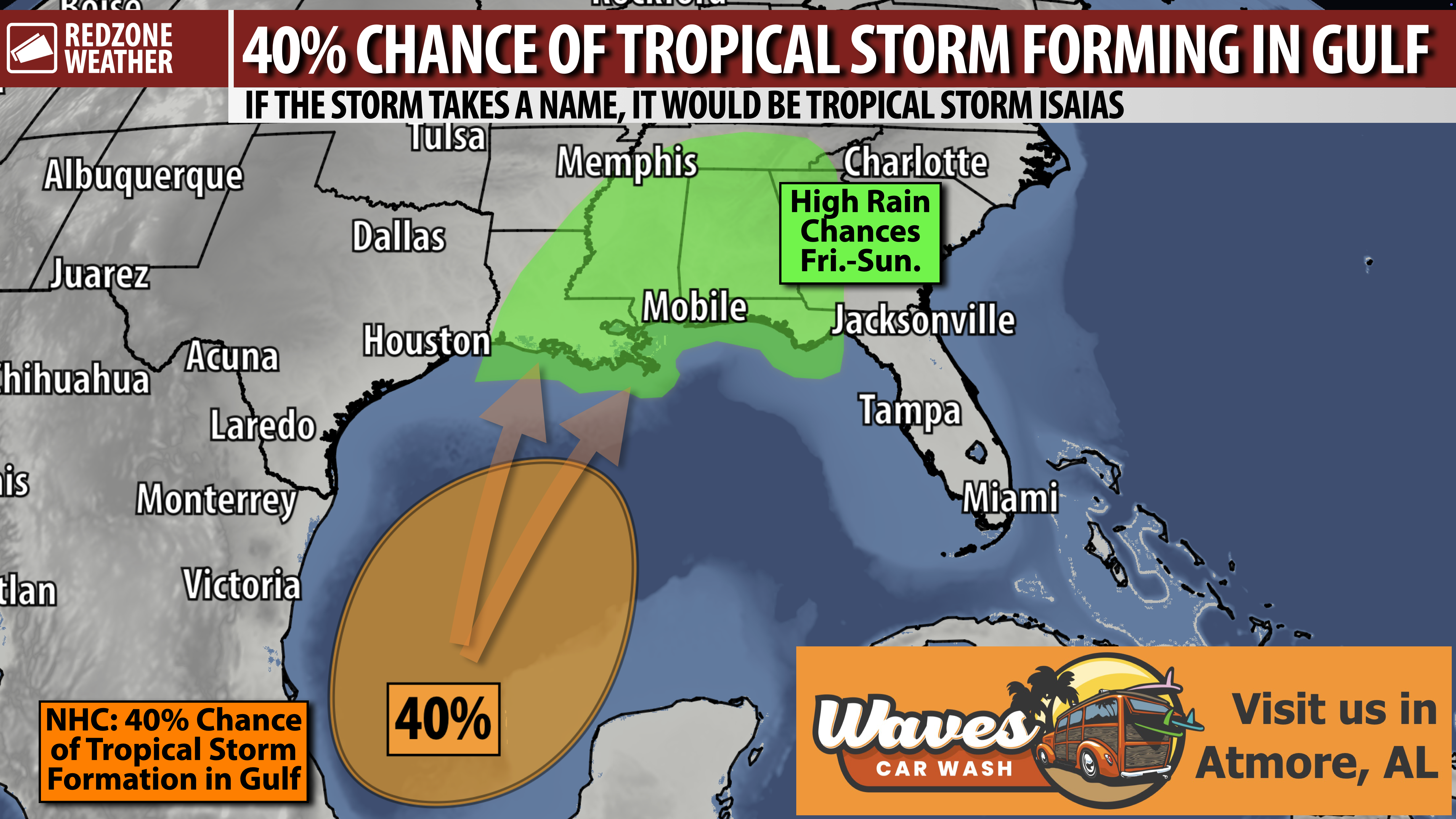
RAIN MOVES OUT TODAY; DRY MIDWEEK AHEAD OF TROPICAL CONCERNS THIS WEEKEND… Rain chances will gradually decrease today across south Alabama and northwest Florida, although scattered showers and a few thunderstorms will continue over the next few hours until the early afternoon. Clouds will hang around into the evening. High temperatures will be near 80 degrees. A mainly dry stretch is ahead for the middle of the week before rain chances increase again Friday into the weekend. We are also monitoring the potential for tropical development in the southwestern Gulf. There is still considerable uncertainty about whether a system forms and what that could mean locally, but increased rain chances seem particularly likely as we get into the upcoming weekend.
SHOWERS & STORMS DECREASE IN COVERAGE TODAY… Scattered showers and a few thunderstorms remain possible over the next several hours as the rain gradually shifts south into the Gulf. This will be a gradual improvement, not an immediate end to rain everywhere. Lingering deep moisture could support localized heavy downpours, with flooding remaining a concern early today, particularly near the coast. Please do not drive across water-covered roadways. Widespread severe weather is not expected, and the Storm Prediction Center has not included our local area in a formal severe weather risk today. Rain chances decrease further tonight, with low temperatures projected to be in the 60s to low 70s.
BEACHES: RIP CURRENT WARNING… Beach conditions remain dangerous even as rain coverage decreases. A High Risk of life-threatening rip currents continues today at Alabama and northwest Florida beaches. Please stay out of the Gulf while these conditions persist. Minor coastal flooding is also possible around high tide early this morning, particularly along coastal Alabama.
MAINLY DRY TUESDAY, WEDNESDAY, AND THURSDAY… Most communities will have much less rain tomorrow, although a few highly isolated showers remain possible. Wednesday and Thursday look like the driest days of the week, with only a very small chance of rain. Clouds may linger in some areas, but we should have intervals of sunshine as well. High temperatures will be in the low to mid 80s Tuesday, followed by low to upper 80s Wednesday and Thursday. Overnight temperatures will dip into the upper 50s in some inland communities by midweek.
RAIN CHANCES SPIKE FRIDAY INTO THE WEEKEND AS TROPICAL MOISTURE MOVES NORTH… Rain chances begin to climb Friday, with a more substantial increase Friday night into Saturday. Showers will likely affect much of the region at times Saturday and Sunday, with rain chances generally around 60-80% during the weekend. That does not mean continuous rain from start to finish, but outdoor plans may have interruptions. Highs will be in the low 80s Friday, followed by upper 70s to low 80s Saturday. The developing Gulf pattern will be important to watch, but higher rain chances alone do not establish that a named storm will affect our area. Specific tropical impacts remain uncertain. Please check back with me for updates in the days ahead.
TROPICS: MEDIUM CHANCE OF DEVELOPMENT IN SOUTHERN GULF… The National Hurricane Center indicates a medium chance of tropical development in the southwestern Gulf over the next 5-7 days. An area of low pressure is likely to form around the middle of this week. Conditions are expected to be only marginally favorable, but slow development is possible, and a tropical depression could form late this week as the system drifts northward. It is too early to know how strong this system might become or where it ultimately goes. I will be closely monitoring trends. Coastal interests should also stay updated, as strengthening easterly flow later this week could bring another round of dangerous surf, rip currents, and perhaps minor coastal flooding.
TROPICS: CARIBBEAN & ATLANTIC QUIET, FOR NOW… The National Hurricane Center is not highlighting any tropical disturbances in the Caribbean Sea or the open Atlantic Ocean at this point. No named storms are currently active across the entire Atlantic Basin. Our tropical focus this week will be on the potential development in the southwestern Gulf, discussed above. The 2026 Atlantic Hurricane Season will officially end on November 30.
APP… redzoneweather.com/app is the link to the free RedZone Weather app. I use the app throughout the day to post brief updates about weather across south Alabama and northwest Florida. After downloading the app, be sure to visit the Alerts tab and customize the specific notifications you’d like to receive.
See all the details in your Monday RedZone Weather forecast video. My next forecast video will be posted by 7:15AM tomorrow morning. I will have updates posted throughout the day, as needed, in the RedZone Weather app.
Have a great start to your week!