8:09AM February 6, 2026
NICE WEATHER THROUGH THE WEEKEND… This weekend will feature fantastic weather across south Alabama and northwest Florida. High temperatures will be in the 60s.
Rain chances rise around the middle part of the upcoming week.

NICE WEATHER THROUGH THE WEEKEND… This weekend will feature fantastic weather across south Alabama and northwest Florida. High temperatures will be in the 60s.
Rain chances rise around the middle part of the upcoming week.
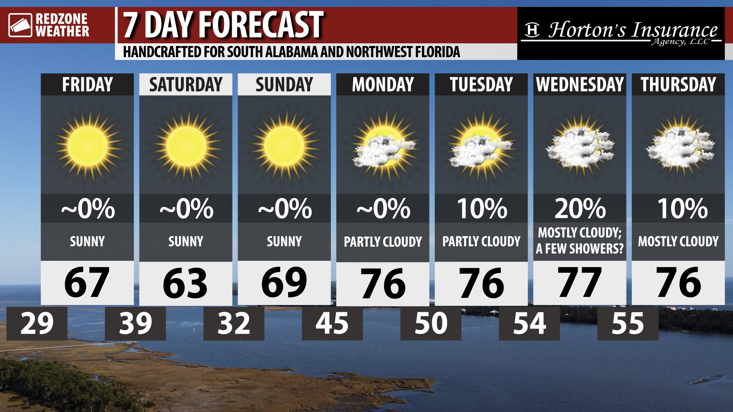
MILDER TEMPS TODAY AND INTO WEEKEND; SHOWERS POSSIBLE NEXT WEEK MIDWEEK… Sunny skies are in the forecast for south Alabama and northwest Florida on this Friday. Afternoon high temperatures will be about 12 to 14 degrees warmer than yesterday with most spots peaking in the 65-69° range today. Clear skies will happen tonight with lows in the 40s. More sunshine is in store for Saturday and Sunday with highs expected to be in the 60s. Fantastic weather will continue through the weekend and into early next week.
WARMER TEMPS NEXT WEEK… The consistent flow of Arctic air into the Southeastern U.S. over the last number of weeks has been shut off, meaning we will have (overall) milder/warmer temperatures in store for the foreseeable future. Afternoon high temperatures are expected to be in the mid 70s next week with morning lows in the 40s and 50s.
RAIN POSSIBLE AROUND MIDWEEK… An area of low pressure developing to our west across parts of Texas and Louisiana will move northeast around the middle part of the upcoming week. This feature will allow showers and perhaps a few thunderstorms to develop across parts of the local area on Tuesday night into Wednesday. It is a bit too early to know if severe storms will be a real possibility, but that is something I will be closely monitoring over the next few days.
APP… If you haven’t already downloaded the RedZone Weather app, now is a great time to do that. redzoneweather.com/app is the link to the free download. Once you have the RZW app installed on your iOS or Android device, be sure to visit the Alerts tab to turn on the specific notifications you’d like to receive. All notifications are handcrafted by me. No automation and we promise not to bug you!
See all the details in your Friday morning RedZone Weather forecast video. My next regularly forecast video will be posted by 7:15AM Monday morning. I will have updates posted throughout the weekend in the RedZone Weather app.
Hope you have a great weekend!

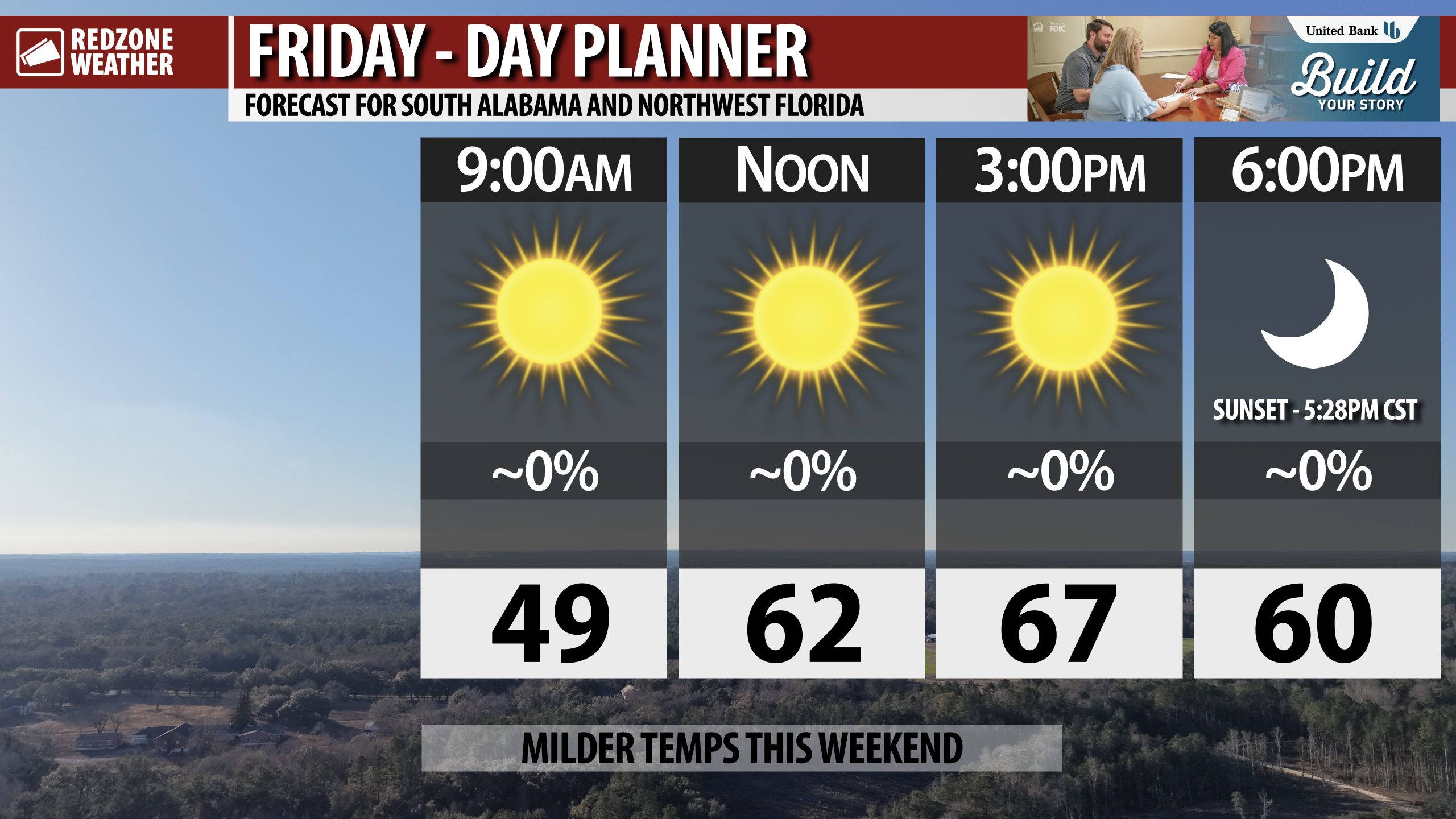
MILDER TEMPS THIS AFTERNOON… Beautiful weather is in store for south Alabama and northwest Florida on this Friday. High temperatures will be about 12 to 14 degrees warmer than yesterday. Most locales will peak in the upper 60s.
Enjoy the day!

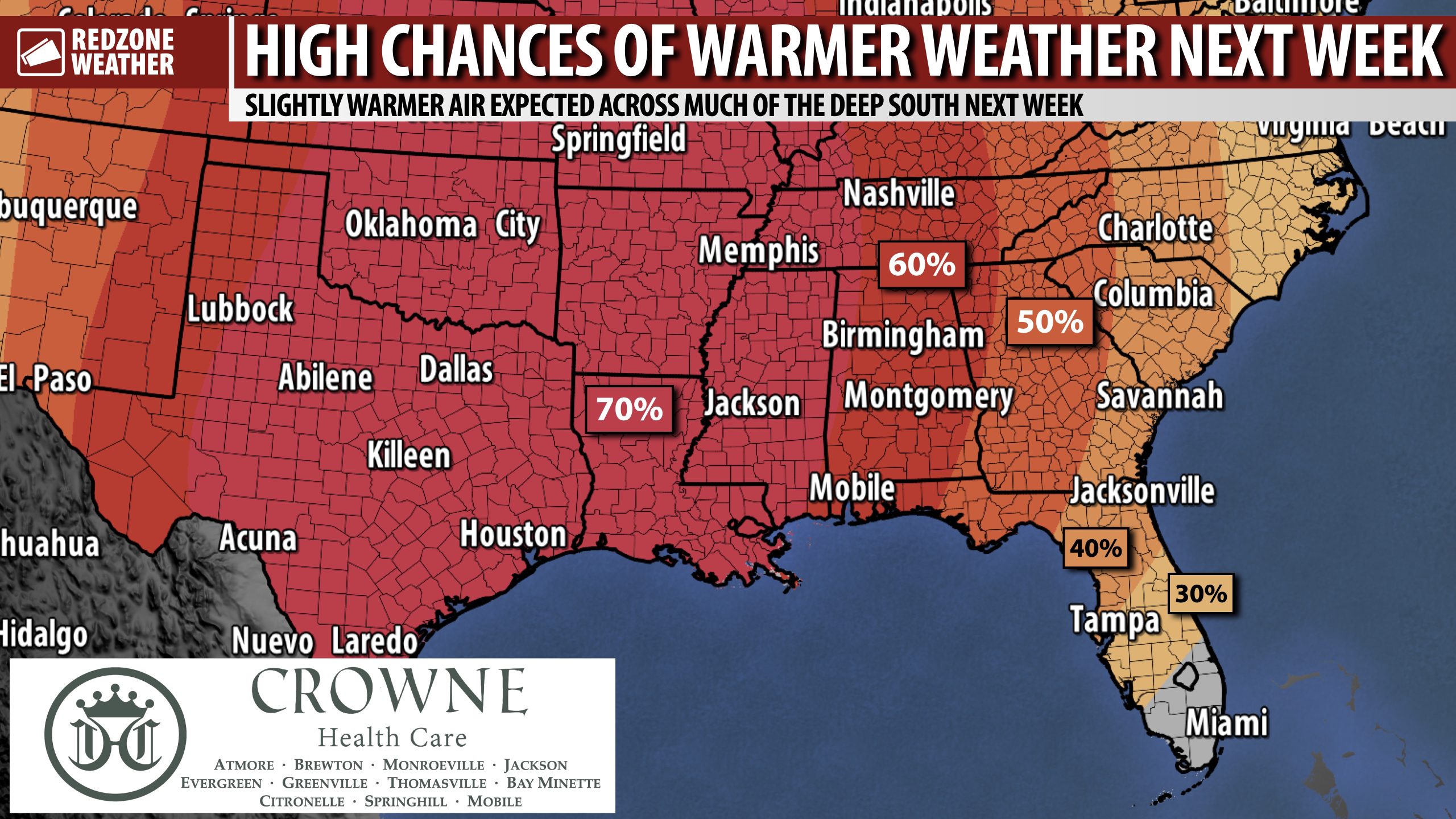
WARMER WEATHER COMING NEXT WEEK… After an extended duration of abnormally cold conditions across much of the Deep South, a pattern flip coming next week will bring a prolonged period of milder/warmer weather. Before we get there, we have one more night (tonight) with near/below freezing temperatures. Overnight lows will range from 27° inland to 34° near the coast. Highs tomorrow will be 10-12 degrees warmer than today with most spots topping out in the upper 60s. Saturday night into Sunday may be cold, potentially with lows near the freezing mark. We’ll be in the 70s early next week with a warmer pattern locked in for several days. Highs will be in the 70s with lows in the 50s next week.
PROLONGED COLD WEATHER PATTERNS ARE NOT THE NORM AROUND HERE… It is so often the case in winter around here that after a cold spell, we have a warmer pattern. Our local weather pattern never “gets cold and stays cold” due to our low latitude. Our winters, compared to our friends further north, are mild in nature usually. This winter and last winter have featured some of the coldest temperatures we have seen in back-to-back years this century. It most certainly is not the norm!
APP… If you haven’t already, be sure to download the free RedZone Weather app to keep up with all the latest information on the world of weather in south Alabama and northwest Florida. redzoneweather.com/app is the link for the free download. Once you have the app downloaded to your iOS or Android device, be sure to visit the Alerts tab (lower right corner) and tap the Alert Settings button to customize the alerts you would like to receive straight from me.
I will have the latest forecast info posted in the morning forecast video tomorrow morning at 7:15AM. Hope you’ll join us then for the latest information.
Have a great Thursday evening!

Clear and cold tonight with lows in the low to mid 30s inland to around 40 along the coast. pic.twitter.com/cHpheN5Fdp
— NWS Mobile (@NWSMobile) February 5, 2026

Yep. Thankfully, this pattern will break next week. Much warmer temps for south Alabama and northwest Florida coming next week! https://t.co/85GjWhr2ju
— Spinks Megginson (@rzweather) February 5, 2026

COLD day in progress across the Deep South on this Thursday. Temperatures are in the 30s across much of Alabama with 40s on the board at midday for northwest Florida.
Afternoon highs will be in the 40s and near 50° today. pic.twitter.com/6xXBwjfOQK
— Spinks Megginson (@rzweather) February 5, 2026
