4:37PM February 21, 2026
Severe Thunderstorm Warning for Dale County in AL until 5:15pm.
— Spinks Megginson (@rzweather) February 21, 2026

Severe Thunderstorm Warning for Dale County in AL until 5:15pm.
— Spinks Megginson (@rzweather) February 21, 2026
RT @AllysonBell17: Looking north towards Atmore @rzweather https://t.co/hATcEpg104
— Spinks Megginson (@rzweather) February 21, 2026

Loud storms near Citronelle, Wallace, Barnett Crossroads, Range, Castleberry, Appleton, Deer Park, Evergreen, and Earlville are moving east.
Storms near Citronelle and Gulfcrest are moving toward Axis and Movico in Mobile County. Nickel-sized hail and 40 mph wind gusts possible. https://t.co/6UH4YqZEsq
— Spinks Megginson (@rzweather) February 21, 2026

Major traffic issues on Interstate 10 in Santa Rosa County, Florida this evening… Thank you to @jmorgan_wx for the tip! https://t.co/VtosUQQNGZ https://t.co/eGIxsGvISa
— Spinks Megginson (@rzweather) February 21, 2026

Loud thunderstorms are happening near Georgiana, McKenzie, Brooks, Oaky Streak, Pigeon Creek, Luverne, and Travis Bridge this afternoon.
Storms are also happening near Monroeville, Frisco City, Excel, Tensaw, and Appleton.
Scattered storms will continue to drift east over the https://t.co/Sap9dS0rEY
— Spinks Megginson (@rzweather) February 21, 2026

At first glance if you’re a casual radar observer, you might think the thunderstorm in southern Clarke County is showing strong signs of rotation. It isn’t. This is a classic sidelobe contamination. https://t.co/RVWVzzZ2Ee https://t.co/0Hk6xIX9F7
— Spinks Megginson (@rzweather) February 21, 2026

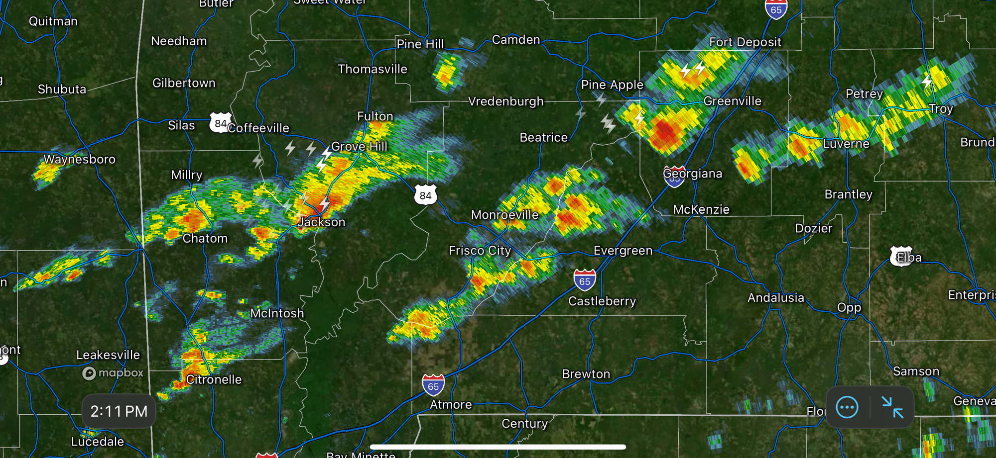
SPOTTY STORMS MOVING EAST… Thunderstorms near Jackson and Walker Springs in Clarke County, AL continue to move east. Gusty winds may be possible shortly near Walker Springs. Strong storms just south of Butler Springs and Forest Home may produce gusty winds soon near Chapman.
Storms are also happening near Repton, Burnt Corn, Goodway, Range, Uriah, Booneville, and Citronelle. These storms aren’t particularly strong, however.
