1:36PM November 8, 2025
Beautiful, warm day across the region! Temperatures are in the upper 70s and low 80s just after 1:30PM. pic.twitter.com/eEKEfuN5wy
— Spinks Megginson (@rzweather) November 8, 2025

Beautiful, warm day across the region! Temperatures are in the upper 70s and low 80s just after 1:30PM. pic.twitter.com/eEKEfuN5wy
— Spinks Megginson (@rzweather) November 8, 2025
On Tuesday morning, parts of the Southeast U.S. will be about as cold as Nuuk, Greenland — near the edge of the Arctic Circle.
It will be warmer in St. John's, Newfoundland, than in parts of northern Florida. pic.twitter.com/SU1TNvQAdx
— Ben Noll (@BenNollWeather) November 7, 2025

Isolated showers and perhaps a thunderstorm or two will be possible overnight. Storms will likely remain below severe limits locally. pic.twitter.com/U1KgrWMygi
— Spinks Megginson (@rzweather) November 8, 2025

Remember that broadly rotating storm in northern Butler County, AL a few hours ago?
This is the aerial view. No reports of damage, thankfully. https://t.co/Mgc92OEjPO
— Spinks Megginson (@rzweather) November 8, 2025

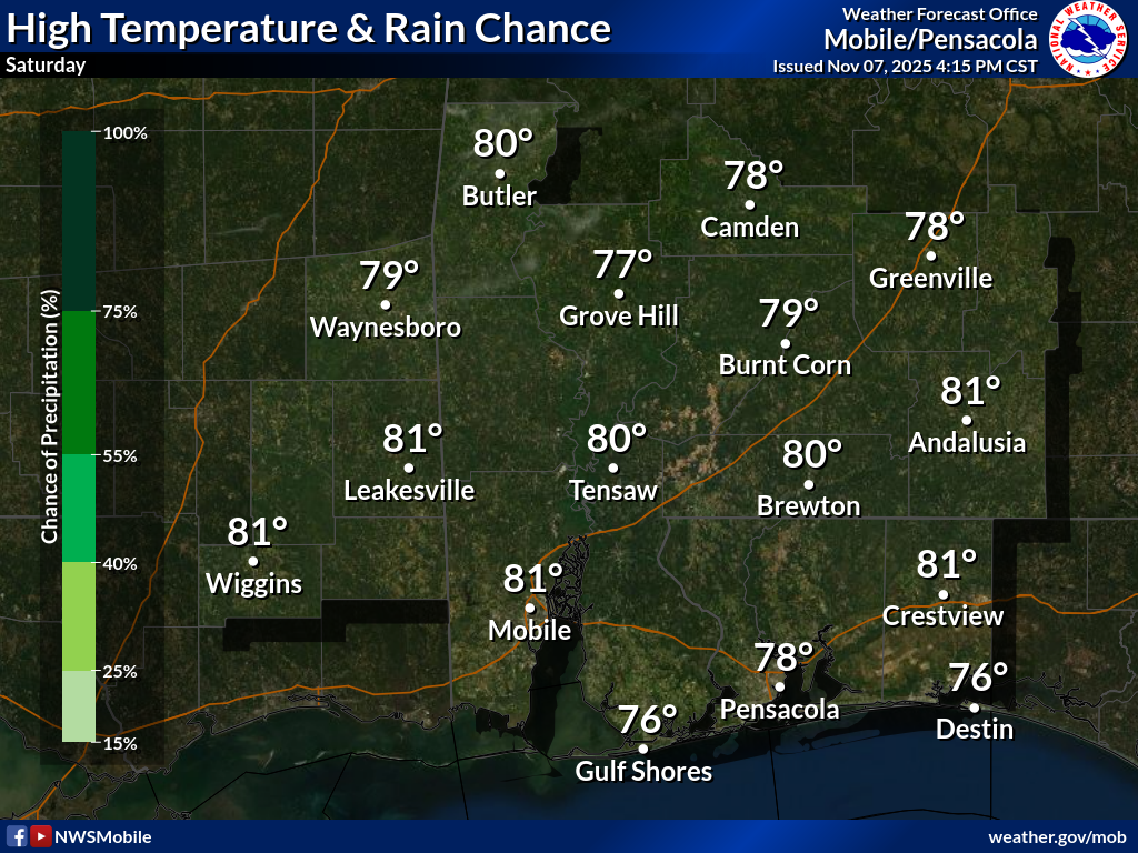
WARM TEMPERATURES THIS AFTERNOON… Any rain showers that develop across the region today will be widely spaced. Most communities will remain dry. High temperatures will be in the upper 70s and low 80s today.
Have a great Saturday!

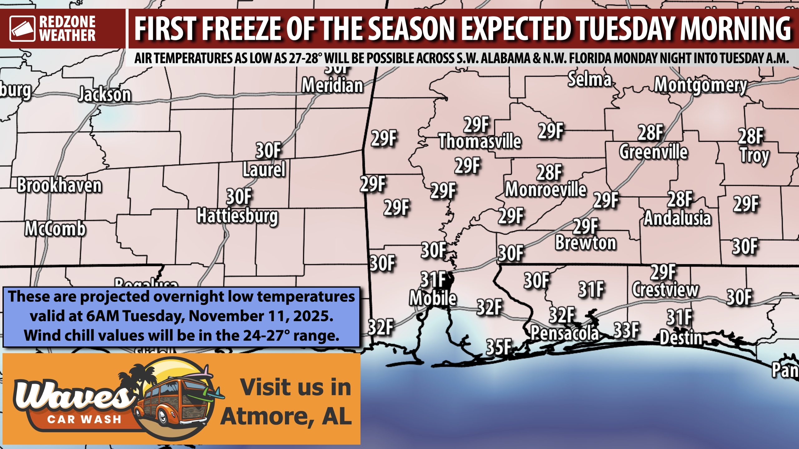
FREEZING TEMPERATURES COMING EARLY NEXT WEEK… Confidence is now very high that the first freeze of the season will happen across south Alabama and northwest Florida on Monday night into early Tuesday morning. Freezing temperatures are likely as far south as Interstate 10 with temperatures as low as 31° possible as far south as the beaches and bays. Inland communities will start the day on Tuesday in the upper 20s. Wind chill values will be in the mid 20s across the region Tuesday morning.
UPDATE ON THE LOW-END SEVERE WEATHER RISK TONIGHT… While a few spotty showers and thunderstorms have happened over the last few hours, the overall threat of severe storms tonight remains exceedingly LOW across the entire region. The risk is not technically zero, but it’s in the lower of the low-end risks we have ever had for sure. Spotty showers and perhaps a few thunderstorms will be possible over the next few hours near the northwest Florida coast. Most places across the region are done with rain for the evening.
WHAT TO EXPECT – SATURDAY… The Storm Prediction Center has taken out the low-end risk zone valid for Saturday, leaving in its place a “general thunderstorms” zone. This is good news. I expect most locales to remain completely dry on Saturday with only a handful of showers and thunderstorms. Mostly cloudy skies will persist all day on Saturday but there will probably be a few areas that have some sunshine. High temperatures will make a run at 80 degrees again tomorrow.
COLD FRONT MOVES THROUGH SUNDAY EVENING… Showers will be possible Sunday morning ahead of clearing skies in the P.M. hours. Temperatures on Sunday will peak in the 70s ahead of a temperature nosedive slated to happen Sunday night after a cold front moves through our local area. Overnight lows by 6AM Monday will be in the 30s and low 40s with highs on Monday struggling to get to the low 50s. Monday will be a cold, blustery, winter-feeling day across the region. That will set the stage for the temperatures you see in the map attached on Tuesday morning.
COLD BLAST WILL BE BRIEF; NO SNOW… No chance of snow or mixed precipitation anytime soon. Just a cold blast of air that will last on Monday and Tuesday. Warmer temperatures will happen later in the week with highs projected to be back into the upper 70s by Thursday.
APP… If you haven’t already downloaded the RedZone Weather app, now is a great time to do that. redzoneweather.com/app is the link to the free download. Once you have the RZW app installed on your iOS or Android device, be sure to visit the Alerts tab to turn on the specific notifications you’d like to receive. All notifications are handcrafted by me. No automation and we promise not to bug you!
Have a nice Friday evening!

Highly isolated showers are happening near NAS Pensacola, Garcon Point, and East Milton as of 8:06PM.
These showers are not at all close to becoming severe storms.
The odds of any severe weather happening locally remains QUITE, quite low. pic.twitter.com/QitFFEAuhJ
— Spinks Megginson (@rzweather) November 8, 2025
