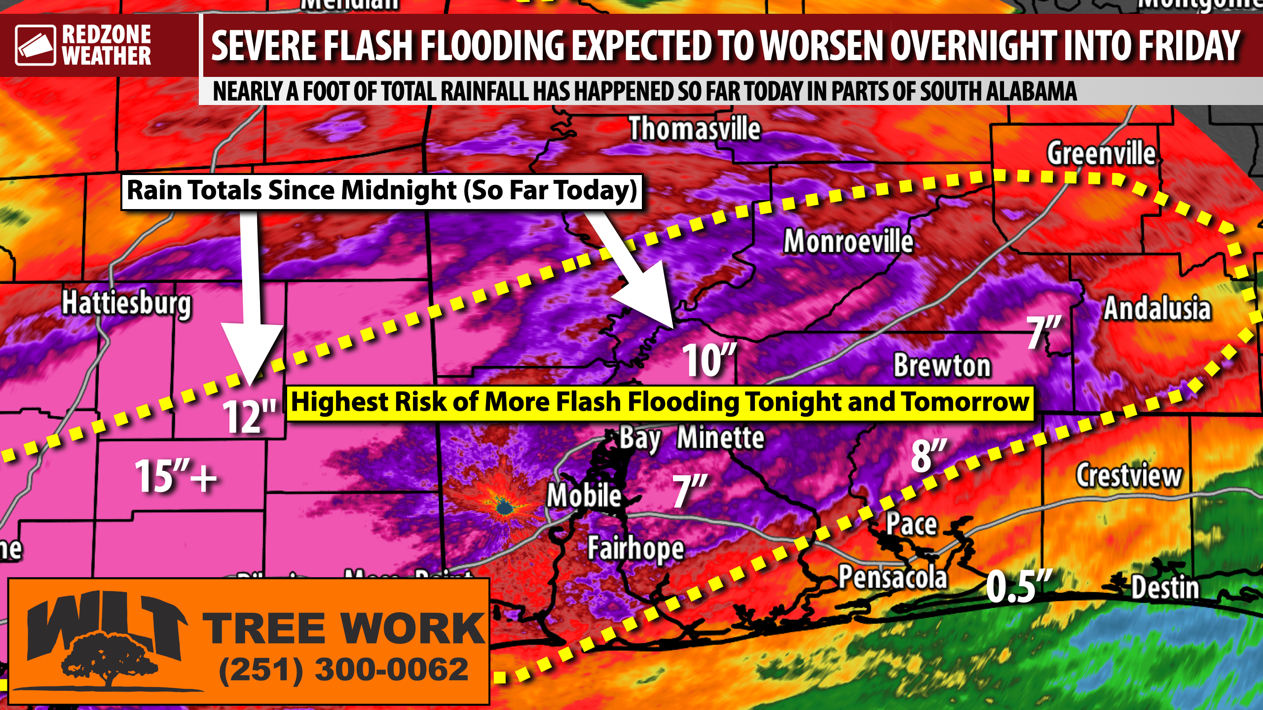
NEARLY A FOOT OF RAIN IN SOME COMMUNITIES TODAY; HARDLY ANY RAIN NEAR THE COAST… Talk about a rainfall gradient across the region today! Severe flash flooding happened and continues to happen due to very heavy rain produced by thunderstorms that moved through earlier this afternoon. Some rain totals so far today: Stockton reports 10.5”, Jay reports 7.94”, Brewton reports 6.95”, Stapleton reports 7”, and Wiggins (MS) has been the epicenter of the action today, reporting over 13.5” (!) of total rainfall. It is wild to think that Stockton has had almost a foot of rain today while communities closer to the beaches have barely had 1”. This event, unfortunately, is far from over.
HEAVY RAIN AND STORMS POSSIBLE INTO THIS EVENING AND TONIGHT… While the overall tornado risk is lower than it was earlier today, the risk is not zero, specifically for areas south and east of I-65. A brief, spin-up tornado can’t be ruled out this evening and into tonight. Gusty winds capable of knocking down trees will also be possible. The biggest problem tonight, however, will likely be heavy rain leading to worsening flash flooding in areas that have already had quite a bit of flash flooding today. An additional 3 to 5 inches of rainfall will be possible overnight and into Friday. Not every community will have that much more rain, but some will.
FLASH FLOOD WARNINGS – UPDATE… We have ongoing Flash Flood Warnings for portions of Mobile, Baldwin, Washington, Clarke, Monroe, Escambia (AL), Conecuh, and Covington counties in south Alabama. Flash Flood Warnings are also in effect for the northern halves of Escambia (FL), Santa Rosa, Okaloosa, and Walton counties. These warnings are in effect until 8:15PM but may need to be extended or reissued if heavier storms continue to develop.
HEAVY RAIN AND STORMS AT 6:30PM… The heaviest rain and storms in our region as of 6:30PM Thursday are happening near Huxford, Uriah, Atmore, Poarch, Stockton, and Tensaw. These storms are slowly moving southeast, and unfortunately, happening right over some of the areas that got 10” of rain earlier today. A strong line of storms is also moving south across Greene, George, Stone, and Perry counties in Mississippi at this hour, again, causing major flash flooding issues to get worse.
UPDATE FOR THE COAST SPECIFICALLY… I know if you’re reading this along the Alabama and northwest Florida beaches or really anywhere south of I-10, you’re probably wondering what all the fuss is about. Rain has not been nearly as prolific in these areas (Pensacola, Milton, Pace, Navarre, Destin, Niceville, Gulf Breeze, Perdido Key, Orange Beach, Foley, and Gulf Shores). Some areas near Navarre and Destin have not had much rain at all. While the greater rain chances will happen inland overnight, some of the storms could make it as far south as the beaches tonight and tomorrow. It looks like these communities will miss the severe flash flooding, however. That’s good news!
WHAT TO EXPECT – FRIDAY… More rain at times and more heavy rain at times, specifically across inland areas of south Alabama and northwest Florida. Due to all of the rain and flooding today, it won’t take much to trigger more in the way of flash flooding tomorrow. Unfortunately, that is exactly what we are expecting. More rain, more flash flooding, with rain totals just tomorrow stacking up to 1 to 3 inches in total. This is a very productive, wet air mass in place across our region. Any storms will be capable of producing torrential rain and flooding. A few strong to severe storms can’t be ruled out tomorrow with gusty winds being the main concern. A tornado or two can’t be ruled out, but I do believe the tornado risk will be less than what we experienced earlier today. Flash flooding is the main problem going forward after tonight.
SPOTTY STORMS INTO THE WEEKEND… Rain will be possible on Saturday and Sunday, at times, but it will be a different setup overall. Thunderstorms will be much more spotty in nature. Storms will pop up quickly and probably go away fairly quickly. It won’t rain all day in any given community on Saturday or on Sunday. High temperatures this weekend will be in the mid to upper 80s.
I will have live coverage for tornado warnings as needed this evening with many, many more updates being posted all evening and into tonight in the RedZone Weather app. My next detailed forecast video will be posted by 7:15AM tomorrow morning.
Have a good Thursday evening and please stay safe!



