
10:10PM February 14, 2026
From Jessica Rhodes: “Happy Mardi Gras from OBA! Photos from tonight’s Mystics of Pleasure parade.” https://t.co/t7H61SJ7bj
— Spinks Megginson (@rzweather) February 15, 2026

From Jessica Rhodes: “Happy Mardi Gras from OBA! Photos from tonight’s Mystics of Pleasure parade.” https://t.co/t7H61SJ7bj
— Spinks Megginson (@rzweather) February 15, 2026
Good point here. Our local radars are KMOB at Mobile Regional Airport and KEVX at Redbay, FL.
If you live near these sites, you’re more likely to get tornado warnings – exclusively because we can actually see them developing UNLIKE in areas that don’t have good radar coverage. https://t.co/IrOn0BRkqu
— Spinks Megginson (@rzweather) February 15, 2026

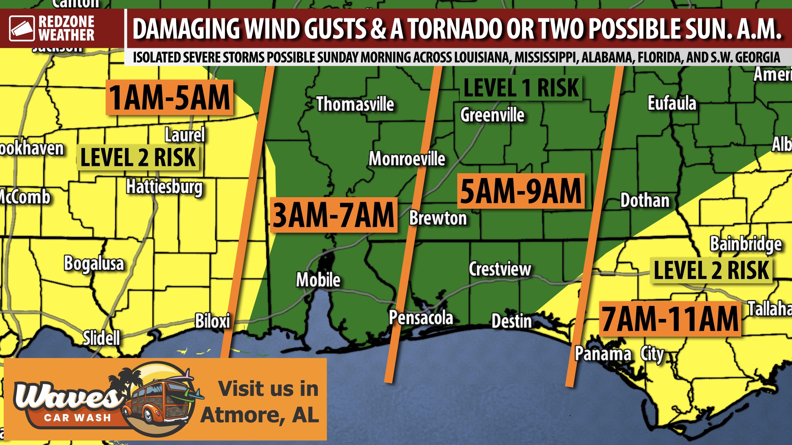
WINDY OVERNIGHT; STRONG TO SEVERE STORMS POSSIBLE OVERNIGHT INTO SUN. MORNING… Strong to marginally severe thunderstorms will be possible TONIGHT into Sunday morning across south Alabama and northwest Florida. Damaging wind gusts and a few tornadoes will be the main concerns. Storms will likely get an earlier start than previously expected. Storms may move into west Alabama as early as 3AM and gradually push across the region, perhaps exiting to the east by 10-11AM. We encourage everyone across the region to have multiple ways to hear warnings overnight, just in case a tornado warning becomes required for your specific location. We have already had several tornado warnings in east Texas and western Louisiana. More warnings are likely as the line of storms move east. Windy conditions are likely ahead of and behind the line of storms as well.
UPDATED SEVERE WEATHER TIMING – SUNDAY… 3AM to 11AM is the initial window for severe storms being possible across the local area on Sunday. The main concern in this initial batch of storms will be damaging wind gusts and few tornadoes. There also is a chance that we have a couple of discrete storms out ahead of the main line of storms that have at least some potential to produce a tornado or two. Confidence is HIGH surrounding the line of storms moving through. Confidence is lower pertaining to the discrete cells out ahead of the line. There is a low-end chance that we have another round of storms in the afternoon/evening hours from 3PM to 7PM. There is much more uncertainty with this second round of storms. Quite frankly, I would not be surprised if the second round of storms did not materialize. The latest high-res guidance simply has a few showers passing through tomorrow evening instead of significant thunderstorm action.
BREEZY CONDITIONS SUNDAY… Windy conditions are expected outside of the thunderstorms, starting Saturday night and existing throughout the day on Sunday and into Sunday evening. Winds will subside Monday in the early morning hours. Tie down any Mardi Gras decorations you have outside this evening before the stronger winds start!
LEVEL 2 (OUT OF 5) RISK TO THE WEST AND TO THE EAST… The good news for southwest Alabama and northwest Florida is our area is somewhat sandwiched in between the “better ingredient zones” for severe storm formation. The Storm Prediction Center has defined a Level 2 (out of 5) severe weather risk for much of Louisiana and southeast Mississippi. Storms will likely be weakening early in the morning on approach to our region, followed by strengthening just after sunrise while storms are rumbling through our local area. Then, when storms reach the Florida Panhandle, southeast Alabama, and southwest Georgia, conditions are more favorable for tornado development. This Level 2 risk includes places like Panama City, Tallahassee, Jacksonville, Lake City, Port St. Joe, Apalachicola, Seaside, Marianna, Wewahitchka, Valdosta (GA), Tifton (GA), and Waycross (GA).
WARM TEMPERATURES TO PERSIST INTO NEXT WEEK… Despite a cold front pushing through on Sunday evening, mild temperatures are here to stay into next week. Afternoon highs will be in the 70s early next week with temperatures near 80° likely by Thursday and Friday. Overnight lows will be in the 40s on Monday night into Tuesday but 50s and 60s are likely for the remainder of the week.
TORNADO WARNING POLICY… Any time there is an active tornado warning in effect for southwest Alabama or northwest Florida, we provide uninterrupted, live video coverage on Facebook Live and YouTube Live. Our detailed coverage commitment is outlined at redzoneweather.com/coverage. We are proud to cover all parts of Escambia (AL), Covington, Monroe, Conecuh, Baldwin, Mobile, Clarke, Washington (AL), Butler, Escambia (FL), Santa Rosa, and Okaloosa counties. If you live in any locale in those counties, be sure to tune into our coverage whenever there is an active tornado warning!
APP ALERTS… redzoneweather.com/app is the link where you can download the free RedZone Weather app. We post brief updates throughout each day in the app, keeping you up-to-date about the latest happenings in weather across south Alabama and northwest Florida. Once you have the free app downloaded to your iOS or Android device, be sure to visit the Alerts tab (lower right corner) then tap the large Alert Settings button to customize the alerts you would like to receive straight from me.
NEXT UPDATES… I will have more updates posted throughout the weekend, as needed, in the RedZone Weather app.
Have a nice Saturday evening!

Storms may move into south Alabama and northwest Florida a bit earlier tomorrow morning, perhaps before sunrise in many communities.
Please have a way to hear warnings overnight! https://t.co/qYYYPC7dZg
— Spinks Megginson (@rzweather) February 15, 2026

New Tornado Watch posted for much of Louisiana and southwest Mississippi valid until 2AM. This includes Baton Rouge, Alexandria, Lake Charles, Monroe (LA), Natchez (MS), Vicksburg (MS), McComb (MS), and Jackson (MS). https://t.co/qaPTniAl6p
— Spinks Megginson (@rzweather) February 15, 2026

Nasty storms near Houston, TX this evening… https://t.co/cKvLnaO8jq
— Spinks Megginson (@rzweather) February 15, 2026

RT @NWSShreveport: KSHV Radar Update – 5:15 PM. A squall line continues to advance eastward across the ArkLaTex. While the portion along I-…
— Spinks Megginson (@rzweather) February 14, 2026
