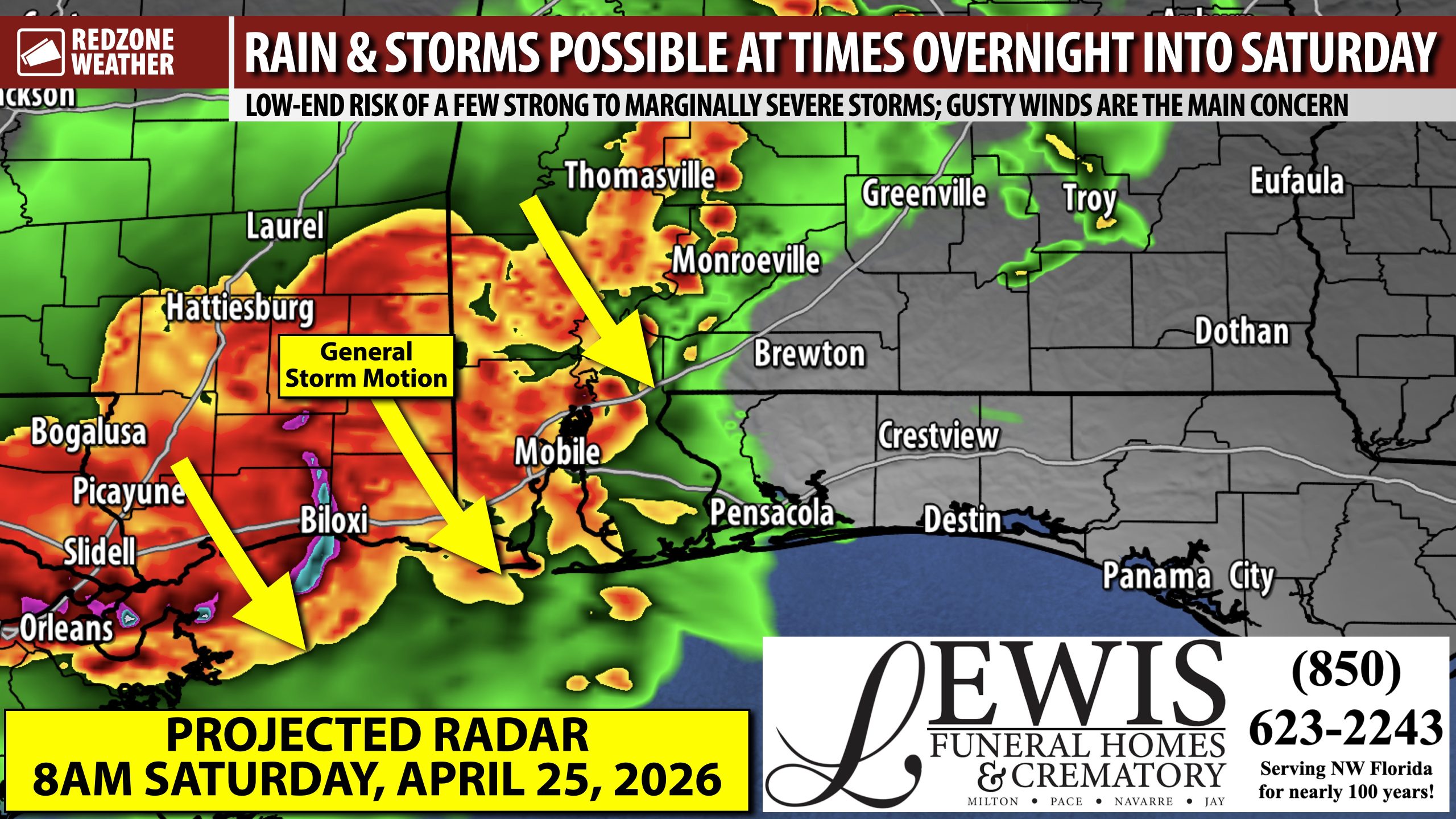
STORMS (WITH BENEFICIAL RAIN!) POSSIBLE OVERNIGHT INTO SATURDAY… Multiple rounds of strong to severe thunderstorms have developed to our west this evening across parts of Mississippi, Louisiana, Arkansas, and Texas. These waves of thunderstorms will ultimately approach south Alabama and northwest Florida over the next 12-18 hours. This points to multiple chances for beneficial rain for our drought-stricken area. A few of the storms may briefly become strong or severe overnight, specifically in parts of southwest Alabama where a low-end, Level 1 (out of 5) severe weather risk is in place. Right now, northwest Florida, coastal Alabama, and south-central Alabama are not involved in any severe weather risk zones, meaning the thunderstorms in those areas will likely be below severe limits.
STORM TIMING – OVERNIGHT INTO SATURDAY… Storms over east Mississippi near Meridian as of 8:10PM are likely to move into west Alabama soon. These storms may reach parts of Washington, Clarke, and Monroe counties in the next couple of hours IF storms maintain their strength. Gusty winds and heavy downpours of rain will be possible in west Alabama from 9PM to midnight with this first batch of storms. A second, distinct batch of storms will likely move into west Alabama overnight after 3AM and ultimately move southeast across south Alabama and perhaps northwest Florida. I intentionally say “perhaps” for northwest Florida as there is a real chance storms completely collapse before getting to northwest Florida and south-central Alabama. If the secondary batch of storms maintains its strength, rain and storms would be possible through midday tomorrow. I will have radar updates posted as needed in the RedZone Weather app.
SEVERE WEATHER CONCERNS… The overall risk of severe storms is low, but not zero, particularly for areas west of the Alabama River in west Alabama. Gusty winds will be the main concern in the stronger storms. The overall tornado risk remains very, very low across south Alabama and northwest Florida. Large hail up to quarter size may be possible in some of the storms. Gusty winds, however, will likely be the main concern overnight into Saturday in any storms that can briefly become severe.
PROJECTED RAIN TOTALS… Rain totals will generally be less than 0.75″ across the region with isolated higher amounts over west Alabama. Unfortunately, this does not look like a long form rain event that our region desperately needs due to the ongoing, severe drought conditions. Any rain is helpful at this point, however.
SPOTTY STORMS POSSIBLE SUNDAY… In addition to the rain chances overnight into Saturday, a few pop-up storms may happen on Sunday as well, predominantly in the afternoon and evening hours. Most locales will remain dry on Sunday as storms will be very scattered in nature. High temperatures on Sunday will again be in the 80s.
TORNADO WARNING POLICY… Any time there is an active tornado warning in effect for southwest Alabama or northwest Florida, we provide uninterrupted, live video coverage on Facebook Live and YouTube Live. Our detailed coverage commitment is outlined at redzoneweather.com/coverage. We are proud to cover all parts of Escambia (AL), Covington, Monroe, Conecuh, Baldwin, Mobile, Clarke, Washington (AL), Butler, Escambia (FL), Santa Rosa, and Okaloosa counties. If you live in any locale in those counties, be sure to tune into our coverage whenever there is an active tornado warning!
APP ALERTS… redzoneweather.com/app is the link where you can download the free RedZone Weather app. We post brief updates throughout each day in the app, keeping you up-to-date about the latest happenings in weather across south Alabama and northwest Florida. Once you have the free app downloaded to your iOS or Android device, be sure to visit the Alerts tab (lower right corner) then tap the large Alert Settings button to customize the alerts you would like to receive straight from me.
I will have updates posted overnight into Saturday, as needed, in the RedZone Weather app. Have a great Friday evening!
