9:22PM May 8, 2026
While showers and storms will be possible outside of these time frames, this the MAIN time frame for storms listed by county for Saturday, May 9, 2026. https://t.co/AtEiFHp8bD
— Spinks Megginson (@rzweather) May 09, 2026

While showers and storms will be possible outside of these time frames, this the MAIN time frame for storms listed by county for Saturday, May 9, 2026. https://t.co/AtEiFHp8bD
— Spinks Megginson (@rzweather) May 09, 2026
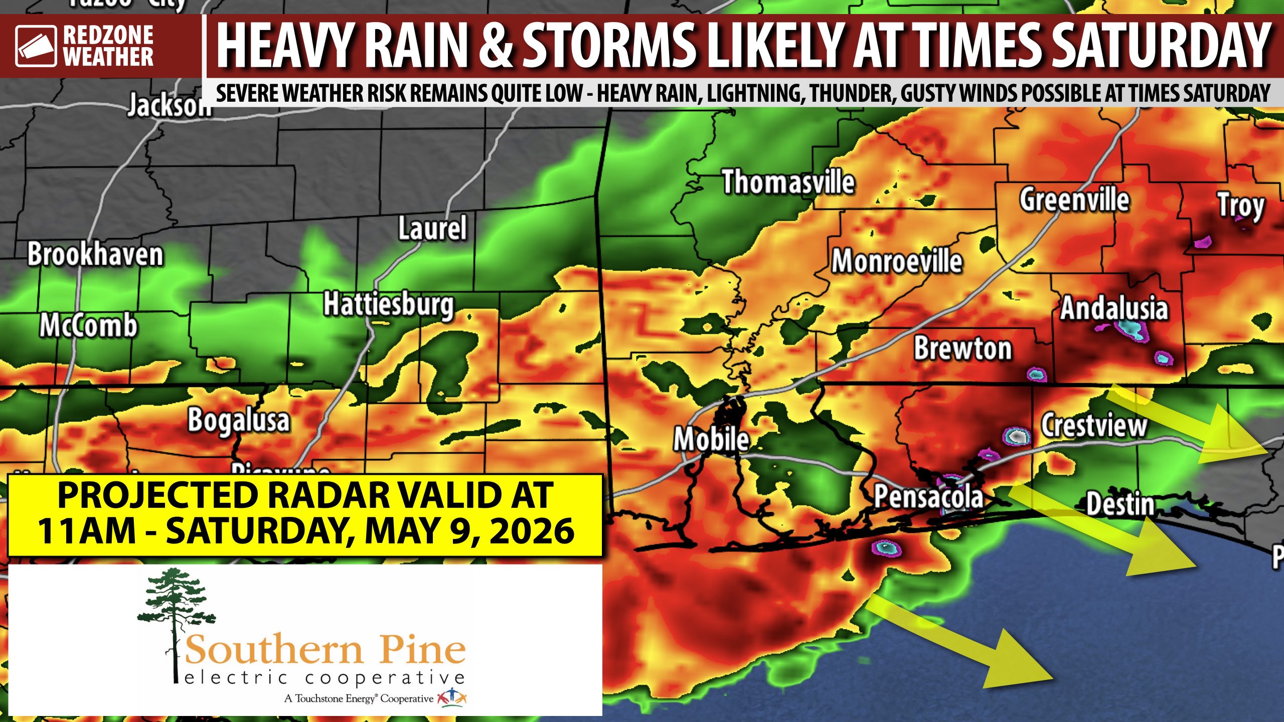
HEAVY RAIN AND THUNDERSTORMS EXPECTED AT TIMES ON SATURDAY… We had some rain across the region today and a lot more is probably on the way for Saturday. The attached image highlights the projected radar valid at Noon on Saturday. If this scenario happens, which seems likely, we would have a southeastward moving complex of heavy rain and thunderstorms. Some of the storms could be strong or even marginally severe with damaging wind gusts being the concern. While the overall tornado risk remains quite low, I can’t rule out some small hail in the storms tomorrow. Unlike today when we had a singular, large storm push directly from west to east across Mobile, Baldwin, Escambia (FL), Santa Rosa, Okaloosa, and Walton counties that brought swaths of trees down and large hail, this will be a more wide scale event that starts in west Alabama and ends up in coastal Alabama and northwest Florida by midday, most likely.
STORM TIMING – SATURDAY… Below is a breakdown for each county of when storms are most likely to be moving through on Saturday. Note that rain and storms could happen before and after these ranges in the form of scattered showers and storms. The ranges below are when the main complex of heavy rain and storms will move through each county.
CHOCTAW COUNTY, AL – 4AM to 7AM
MARENGO COUNTY, AL – 5AM to 8AM
WASHINGTON COUNTY, AL – 5AM to 8AM
CLARKE COUNTY, AL – 6AM to 9AM
WILCOX COUNTY, AL – 6AM to 9AM
MOBILE COUNTY, AL – 7AM to 10AM
BALDWIN COUNTY, AL – 7AM to 10AM
MONROE COUNTY, AL – 7AM to 10AM
ESCAMBIA COUNTY, AL – 8AM to 11AM
CONECUH COUNTY, AL – 8AM to 11AM
BUTLER COUNTY, AL – 8AM to 11AM
CRENSHAW COUNTY, AL – 8AM to 11AM
COVINGTON COUNTY, AL – 9AM to Noon
PIKE COUNTY, AL – 9AM to Noon
COFFEE COUNTY, AL – 9AM to Noon
GENEVA COUNTY, AL – 9AM to Noon
ESCAMBIA COUNTY, FL – 8AM to 11AM
SANTA ROSA COUNTY, FL – 9AM to Noon
OKALOOSA COUNTY, FL – 9AM to Noon
WALTON COUNTY, FL – 10AM to 1PM
EXTREMELY BENEFICIAL RAINFALL; THUNDER & LIGHTNING EXPECTED… I realize the rain tomorrow will put a damper on many outdoor events, but quite frankly, this is exactly what we need: Multiple days of rainfall with some heavy rain mixed in at times to help get rid of the severe drought conditions. Saturday should be an immense help in that process with 1-3″ of total rainfall (just tomorrow!) being likely in many spots across the region. If you have an outdoor event planned, I would certainly have an indoor backup. I would strongly advise not being on a river or creek tomorrow (kayaking, swimming, or just being on a sand bar) as lightning will be prolific in some of the storms. Rain will probably last quite awhile in most communities.
UPDATE ON THE SEVERE WEATHER RISK… The Storm Prediction Center maintains a low-end, Level 1 (out of 5) severe weather risk valid for the entirety of south Alabama and northwest Florida for the next 48 hours – Saturday, Saturday night, into Sunday. The concern will be along the leading edge of the storms that move in tomorrow. Gusty winds capable of knocking down trees will be the main concern. Hail up to quarter size may be possible in some of the storms. The overall tornado risk remains very low. Not entirely zero, but very low. Thunder may be quite loud and cloud-to-ground lightning is almost a certainty on the leading edge of the storms that develop.
MORE RAIN ON SUNDAY… Another round of rain and storms seems likely on Sunday. Let’s get through the storm event tomorrow then we will focus on the details about Sunday. Our weather pattern turns drier, for a few days at least, on Monday afternoon.
APP… If you haven’t already downloaded the RedZone Weather app, now is a great time to do that. redzoneweather.com/app is the link to the free download. Once you have the RZW app installed on your iOS or Android device, be sure to visit the Alerts tab to turn on the specific notifications you’d like to receive. All notifications are handcrafted by me. No automation and we promise not to bug you!
I will have updates posted, as needed, tonight and into tomorrow morning in the RedZone Weather app. When we are not in live tornado warning coverage, I am posting constantly in the RedZone Weather app when our area has thunderstorms around.
Have a great weekend!

HEAVY RAIN AND THUNDERSTORMS EXPECTED AT TIMES ON SATURDAY… We had some rain across the region today and a lot more is probably on the way for Saturday. The attached image highlights the projected radar valid at Noon on Saturday. If this scenario happens, which seems likely, we https://t.co/EWnEWK2NU7
— Spinks Megginson (@rzweather) May 09, 2026

MOST spots across south Alabama and northwest Florida (unless you’re right at the coast) will be drier overnight. Saturday, however, will likely be QUITE WET with numerous storms around.
This is the projected radar loop from 11PM tonight to 9AM tomorrow. https://t.co/DXTlpMz8cx
— Spinks Megginson (@rzweather) May 08, 2026

No warnings anytime in the next hour, most likely. This is a big, beautiful, beneficial shield of rain in place across south Alabama and northwest Florida.
Intermittent rain will continue across much of the area into tonight. https://t.co/6TAn7UD1PB
— Spinks Megginson (@rzweather) May 08, 2026

Rain and occasional thunderstorms will continue across south Alabama and northwest Florida over the next few hours.
More rain is happening inland than at the coast, for now. https://t.co/V3fFXDVkS7
— Spinks Megginson (@rzweather) May 08, 2026

Strong thunderstorms near Crestview, Baker, Blackman, Campton, Holt, and Auburn (FL) are moving east.
HEADS UP if you’re in Laurel Hill, Dorcas, Deerland, or northern Walton County: Storms are moving your way next. Gusty winds, heavy rain, lots of lightning! https://t.co/HD8zuG1TOW
— Spinks Megginson (@rzweather) May 08, 2026
