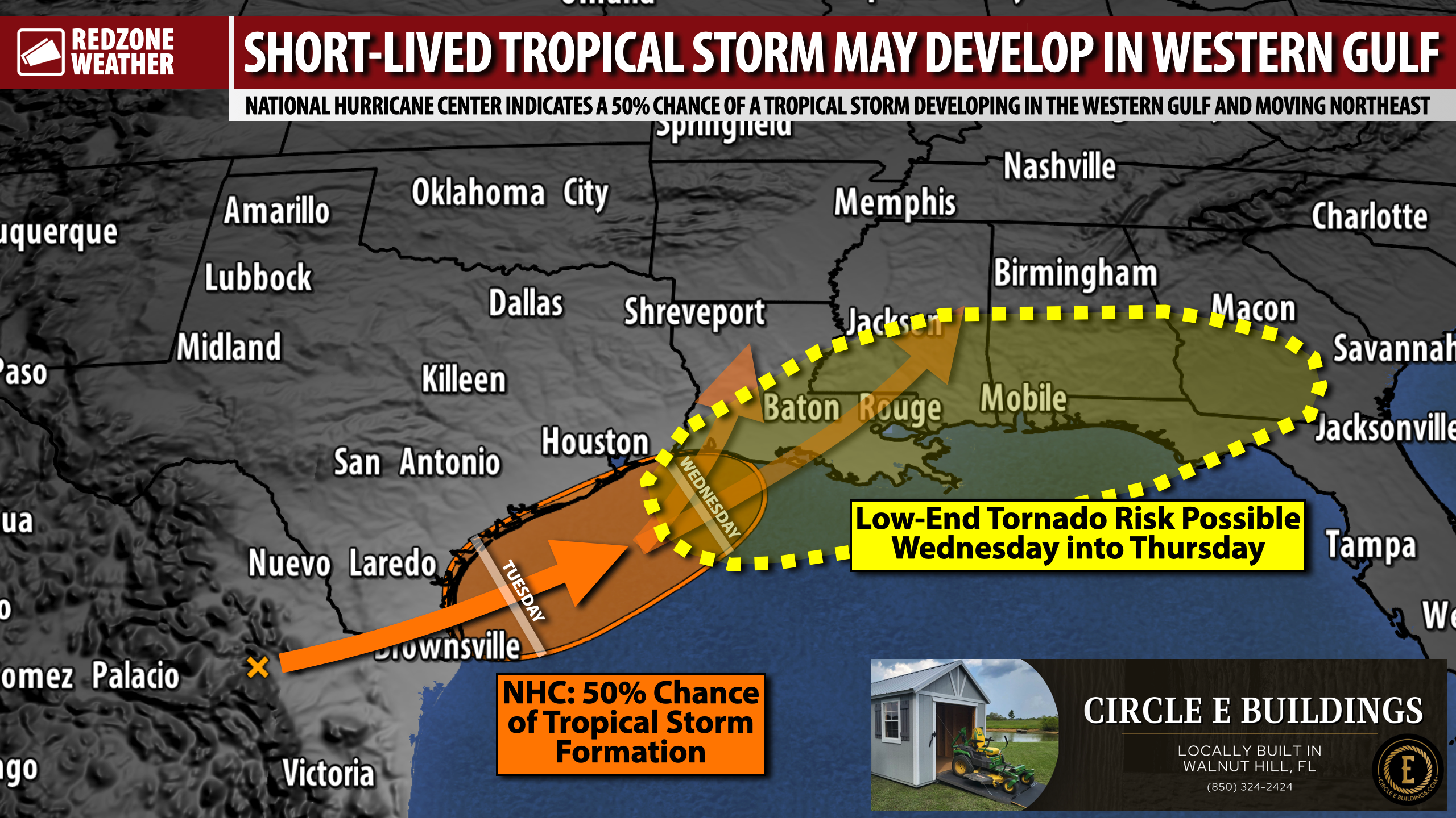
TROPICAL STORM MAY DEVELOP IN WESTERN GULF; TORNADO RISK POSSIBLE LOCALLY THURSDAY… Heavy rain and thunderstorms are likely at times in the days ahead as a tropical system approaches south Alabama and northwest Florida from the southwest. The probabilities of development for this system have increased. The National Hurricane Center indicates there is a 40-50% chance the disturbance becomes a named tropical storm before landfall on Wednesday in parts of Texas or Louisiana. Regardless of the status of the storm (whether it is named or not), the impacts for the local area remain the same: Waves of heavy rain, flash flooding increasingly likely where storms train over the same areas, and perhaps a tornado risk on Wednesday night into Thursday.
TORNADO RISK POSSIBLE LATE WEDNESDAY NIGHT INTO THURSDAY… Strong to severe thunderstorms capable of producing tornadoes may become possible late Wednesday into much of the day on Thursday as this area of low pressure passes by the region. It is a bit too early for timing specifics but please be aware that we may have a tornado risk setting up for Thursday across all of south Alabama and northwest Florida. Spotty storms will continue to be possible into the weekend, but the severe weather/tornado risk should end by Thursday evening. This is something I will be monitoring carefully over the next few days.
NAME OR NO NAME – IMPACTS REMAIN THE SAME… It really won’t matter much if the tropical system in question, currently situated over northern Mexico, becomes a named tropical storm. The impacts from the system across Alabama and northwest Florida remain the same. The biggest, most widespread impact will very likely be heavy rain that could lead to flash flooding. Rain amounts of 3 to 7” in total through Friday are expected across the local area with the higher rain amounts expected further inland near the US84 corridor.
PROJECTED RAIN TOTALS… 5-7” of total rain through Friday is the expectation for places like Thomasville, Monroeville, Chatom, Millry, Evergreen, Greenville, Camden, and points north. These are the communities that have the highest risk of flash flooding at times in the days ahead if/when rain and storms train over the same areas. 3-5” of total rain through Friday is expected in places like Mobile, Spanish Fort, Daphne, Foley, Bay Minette, Pensacola, Atmore, Brewton, Jay, Milton, Pace, Andalusia, Opp, and Crestview. 2-4” of total rain through Friday is expected near the Alabama and northwest Florida beaches. Quite a bit of rain has happened today north of US84 across inland stretches of south Alabama, despite hardly any rain in northwest Florida and coastal Alabama. This will, unfortunately, pave the way for storms to quickly cause flash flooding over the next few days.
MINOR COASTAL FLOODING POSSIBLE… Minor coastal flooding will be possible from Wednesday afternoon, through Thursday, and into Friday morning. The greatest risk of coastal flooding will likely happen near Mobile and the Causeway where coastal flooding of 1-2 feet may be possible. This type of flooding is capable of causing over wash on the Causeway. Very minor coastal flooding impacts could happen near Bayou La Batre, Dauphin Island, Gulf Shores, Orange Beach, and Pensacola Beach. Widespread surge and major impacts are highly unlikely.
TORNADO WARNING POLICY… Any time there is an active tornado warning in effect for southwest Alabama or northwest Florida, we provide uninterrupted, live video coverage on Facebook Live and YouTube Live. Our detailed coverage commitment is outlined at redzoneweather.com/coverage. We are proud to cover all parts of Escambia (AL), Covington, Monroe, Conecuh, Baldwin, Mobile, Clarke, Washington (AL), Butler, Escambia (FL), Santa Rosa, and Okaloosa counties. If you live in any locale in those counties, be sure to tune into our coverage whenever there is an active tornado warning!
APP ALERTS… redzoneweather.com/app is the link where you can download the free RedZone Weather app. We post brief updates throughout each day in the app, keeping you up-to-date about the latest happenings in weather across south Alabama and northwest Florida. Once you have the free app downloaded to your iOS or Android device, be sure to visit the Alerts tab (lower right corner) then tap the large Alert Settings button to customize the alerts you would like to receive straight from me.
My next detailed forecast video will be posted by 7:15AM tomorrow morning. Have a great Monday evening!
