4:00PM 8/23/2020 – RZW Exec

RZW EXEC: FEW TORNADOES POSSIBLE MONDAY… RZW Exec partners, the risk of a few tornadoes has increased for Monday across south Alabama and northwest Florida, especially in areas closer to the coast. OVERALL, I expect local impacts to be pretty limited. I have outlined the overall risk in each local county, in detail, for our early evening update. Wind impacts really won’t be much of an issue locally due to Marco. We could have some limited flash flooding issues and maybe a few, brief tornadoes. That is the summary, below is an extensive post about all of this that breaks everything down by specific counties. As always, please let me know if you have any questions! My cell phone number for those that may not have it is (251) 363-8833. I am bad about not checking emails when we have severe weather issues like this, but I do a lot better with text messages. Shoot me a text if you have decision support needs. Thank you & stay safe!

LONG POST: TORNADOES POSSIBLE MONDAY DUE TO HURRICANE MARCO… You’ll find a detailed assessment below as to what to expect in each of our local counties due to Hurricane Marco, which will likely make a Louisiana landfall as a hurricane some time on Monday. Local impacts from Marco could extend into Monday night, especially near the Alabama and northwest Florida beaches. Since the core of Marco will likely move southwest of us, impacts locally will be limited to isolated tornadoes, heavy rain that could lead to flash flooding, and beach hazards (gusty winds of 25-35 mph at the immediate coast, high waves, rip currents, minor storm surge, and minor coastal flooding). Our region will be on the more volatile east side of the system and with the high shear environment over Marco, there is a good chance we will have quite a bit of rain streaming into our region on Monday.

TIMING – POTENTIAL FOR TORNADOES LOCALLY… Isolated tornadoes will be possible across parts of south Alabama and northwest Florida from 7AM Monday to 1AM Tuesday. That is the 18 hour window when a few, brief tornadoes may happen locally as the core of Marco passes to our southwest. We encourage everyone to have a way to receive urgent tornado warnings on Monday into Monday night. You need something like a NOAA Weather Radio or smartphone app that is designed to wake you up. It is a good idea to visit your smartphone’s notification settings and make sure Wireless Emergency Alerts (WEAs) are turned ON.

TORNADO WARNING POLICY… Any time there is an active tornado warning in effect for southwest Alabama or northwest Florida, we provide uninterrupted, live video coverage on Facebook Live and in the RedZone Weather app. Our detailed coverage commitment is outlined at redzoneweather.com/coverage. We are proud to cover all parts of Escambia (AL), Covington, Monroe, Conecuh, Baldwin, Mobile, Clarke, Washington, Butler, Escambia (FL), Santa Rosa, and Okaloosa counties. If you live in any locale in those counties, be sure to tune into our coverage whenever there is an active tornado warning!

LEVEL 2 (OUT OF 5) TORNADO RISK… The Storm Prediction Center has added a Level 2 (out of 5) tornado risk starting at 7AM on Monday for parts of Mobile and Baldwin counties in Alabama, coastal Mississippi, and much of eastern Louisiana, including greater New Orleans. These are the zones where brief tornadoes will be most likely to happen Monday into Monday night. Instead of listing each community in the risk zones (that are meant to be more generalized guidelines), see specific impacts for each county below.

LEVEL 1 (OUT OF 5) TORNADO RISK… Surrounding the Level 2 risk, there is a Level 1 (out of 5), lower-end tornado risk that includes parts of Escambia (FL), Santa Rosa, Okaloosa, Mobile, and Baldwin counties. Instead of listing each community in the risk zones (that are meant to be more generalized guidelines), see specific impacts for each county below.

MOBILE COUNTY, AL… All potential impacts will likely be more pronounced at the immediate coastline near Dauphin Island and along the western shore of Mobile Bay. 25-35 mph wind gusts are expected. No widespread, damaging winds are expected since the core of Marco will pass to our southwest. Isolated tornadoes will be possible Monday into Monday night. Heavy rain that could lead to flash flooding could happen, especially Monday evening. Beach hazards are likely, including minor storm surge, minor coastal flooding, high waves, and dangerous rip currents.

Locations: Mobile, Prichard, Citronelle, Mt. Vernon, Creola, Satsuma, Saraland, Calvert, Wilmer, West Mobile, Bayou La Batre, Coden, Alabama Port, Dauphin Island, Theodore, Crichton, Tanner Williams, Tillmans Corner, Chunchula, Grand Bay.

BALDWIN COUNTY, AL… All potential impacts will likely be more pronounced at the immediate coastline near Orange Beach, Gulf Shores, and Fort Morgan. 25-35 mph wind gusts are expected. No widespread, damaging winds are expected since the core of Marco will pass to our southwest. Isolated tornadoes will be possible Monday into Monday night. Heavy rain that could lead to flash flooding could happen, especially Monday evening. Beach hazards are likely, including minor storm surge, minor coastal flooding, high waves, and dangerous rip currents.

Locations: Daphne, Fairhope, Spanish Fort, Gulf Shores, Orange Beach, Fort Morgan, Magnolia Springs, Foley, Elberta, Elsanor, Robertsdale, Summerdale, Silverhill, Montrose, Loxley, Stapleton, Bay Minette, Stockton, Rabun, Perdido, Tensaw, Point Clear.

ESCAMBIA COUNTY, FL… All potential impacts will likely be more pronounced at the immediate coastline near Perdido Key, Fort Pickens, NAS Pensacola, Gulf Breeze, and Pensacola Beach. 25-35 mph wind gusts will be possible. No widespread, damaging winds are expected since the core of Marco will pass to our southwest. Isolated tornadoes will be possible Monday into Monday night. Heavy rain that could lead to flash flooding could happen, especially Monday evening. Beach hazards are likely, including minor storm surge, minor coastal flooding, high waves, and dangerous rip currents.

Locations: Pensacola, Pensacola Beach, Perdido Key, Warrington, Myrtle Grove, Molino, Walnut Hill, Bratt, Century, Ensley, Gonzalez, Cantonment, Quintette, McDavid.

SANTA ROSA COUNTY, FL… All potential impacts will likely be more pronounced at the immediate coastline near Gulf Breeze and Navarre. 20-30 mph wind gusts will be possible. Isolated tornadoes will be possible Monday into Monday night. No widespread, damaging winds are expected since the core of Marco will pass to our southwest. Heavy rain that could lead to flash flooding could happen, especially Monday evening. Beach hazards are likely, including minor storm surge, minor coastal flooding, high waves, and dangerous rip currents.

Locations: Navarre, Jay, Milton, Pace, Gulf Breeze, Harold, Whiting Field, Chumuckla, New York, Brownsdale, Berrydale, Munson, Fidelis, McClellan, Mulat, Bagdad, Pine Bluff, Avalon Beach, Garcon Point, Whitfield, Allentown.

OKALOOSA COUNTY, FL… All potential impacts will likely be more pronounced at the immediate coastline near Gulf Breeze and Navarre. 15-25 mph wind gusts will be possible. No widespread, damaging winds are expected since the core of Marco will pass to our southwest. Isolated tornadoes will be possible Monday into Monday night. Heavy rain that could lead to flash flooding could happen, especially Monday evening. Beach hazards are likely, including minor storm surge, minor coastal flooding, high waves, and dangerous rip currents.

Locations: Destin, Fort Walton Beach, Niceville, Mary Esther, Wright, VPS, Eglin AFB, Crestview, Deerland, Campton, Auburn (FL), Baker, Holt, Milligan, Laurel Hill.

WASHINGTON COUNTY, AL… Isolated tornadoes will be possible Monday into Monday night. Heavy rain that could lead to flash flooding could happen, especially Monday evening. Breezy (10-25 mph wind gusts) conditions may become possible Monday evening. No widespread, damaging winds are expected since the core of Marco will pass to our southwest. Heavy rain that could lead to flash flooding could happen, especially Monday evening.

Locations: Chatom, Leroy, McIntosh, Millry, Deer Park, Vinegar Bend, Fruitdale, Yellow Pine, Copeland, Yarbo, Jordan, Bigbee, St. Stephens, Tibbie, Sims Chapel, Sunflower, Malcolm.

CLARKE COUNTY, AL… Limited to no major impacts. Isolated tornadoes will be possible Monday into Monday night. Heavy rain that could lead to flash flooding could happen, especially Monday evening. Breezy (10-25 mph wind gusts) conditions may become possible Monday evening. No widespread, damaging winds are expected since the core of Marco will pass to our southwest. Heavy rain that could lead to flash flooding could happen, especially Monday evening.

Locations: Thomasville, Grove Hill, Jackson, Coffeeville, Fulton, Carlton, Gainestown, Gosport, Whatley, Scyrene, Springfield, Chilton, Tallahatta Springs, Bashi, Woods Bluff, Campbell, Zimco, Toddtown, Salitpa, Suggsville, Alma, Dickinson, West Bend, Winn, Walker Springs.

MONROE COUNTY, AL… Limited to no major impacts. Isolated tornadoes will be possible Monday into Monday night. Heavy rain that could lead to flash flooding could happen, especially Monday evening. Breezy (10-20 mph wind gusts) conditions may become possible Monday evening. No widespread, damaging winds are expected since the core of Marco will pass to our southwest. Heavy rain that could lead to flash flooding could happen, especially Monday evening.

Locations: Monroeville, Excel, Uriah, Frisco City, Megargal, Mineola, Chrysler, Goodway, Peterman, Tunnel Springs, Beatrice, Riley Crossing, Perdue Hill, Mexia, Scratch Ankle, Hybart, Franklin, Eliska.

ESCAMBIA COUNTY, AL… Limited to no major impacts. Isolated tornadoes will be possible Monday into Monday night. Heavy rain that could lead to flash flooding could happen, especially Monday evening. Breezy (10-20 mph wind gusts) conditions may become possible Monday evening. No widespread, damaging winds are expected since the core of Marco will pass to our southwest. Heavy rain that could lead to flash flooding could happen, especially Monday evening.

Locations: Brewton, East Brewton, Atmore, Flomaton, Riverview, Poarch, Huxford, Wallace, Barnett Crossroads, Pineview, Wawbeek, Canoe, Nokomis, Appleton, Kirkland, Dixie, Roberts, Damascus, Pollard/McCall.

CONECUH COUNTY, AL… No major impacts are expected. Isolated tornadoes will be possible Monday into Monday night, but the risk is greater in counties to the southwest. Heavy rain that could lead to flash flooding could happen, especially Monday evening. Breezy (10-20 mph wind gusts) conditions may become possible Monday evening. No widespread, damaging winds are expected since the core of Marco will pass to our southwest. Heavy rain will be possible at times Monday into Monday night.

Locations: Evergreen, Castleberry, Owassa, Repton, Lenox, Range, Burnt Corn, Lyeffion, Centerville, Johnsonville, Brooklyn, Paul, Melrose, Old Sparta, Jay Villa, Belleville.

COVINGTON COUNTY, AL… No major impacts are expected. Isolated tornadoes will be possible Monday into Monday night, but the risk is greater in counties to the southwest. Heavy rain that could lead to flash flooding could happen, especially Monday evening. Breezy (10-20 mph wind gusts) conditions may become possible Monday evening. No widespread, damaging winds are expected since the core of Marco will pass to our southwest. Heavy rain will be possible at times Monday into Monday night.

Locations: Andalusia, Opp, Florala, Rose Hill, Onycha, Red Oak, Green Bay, Straughn, Red Level, Gantt, Clearview, Carolina, Pleasant Home, Wing, Sanford, Libertyville, Eoda, Horn Hill, Lockhart, River Falls, Loango, Fairfield.

BUTLER COUNTY, AL… No major impacts are expected. Isolated tornadoes will be possible Monday into Monday night, but the risk is greater in counties to the southwest. Heavy rain that could lead to flash flooding could happen, especially Monday evening. Breezy (10-20 mph wind gusts) conditions may become possible Monday evening. No widespread, damaging winds are expected since the core of Marco will pass to our southwest. Heavy rain will be possible at times Monday into Monday night.

Locations: Greenville, Georgiana, Chapman, Bolling, Grace, Garland, Oaky Streak, Daisy, Halso Mill, Starlington, Forest Home.

QUICK UPDATE ON TROPICAL STORM LAURA… Tropical Storm Laura is now centered in the Windward Passage, between Haiti and Cuba. Doppler radar imagery from Guantanamo Bay, Cuba shows the center of circulation moving west. It appears, based on this observation, that the potential for the center of Laura to track north of Cuba or hug the northern coastline of Cuba is now off the table. Models have struggled today with the initialization of Laura. Basically that means that the global models are not picking up the exact center of Laura, thus if you start with the wrong center, odds are you end up with a model output that is potentially significantly wrong in terms of the future track and intensity. I imagine models will begin to get a better grasp gradually tonight into Monday. The overall general idea for Laura has not changed, however. We expect Laura to continue to move northwest over Cuba through tomorrow morning before emerging in the southeastern Gulf on Monday evening. Laura will likely continue to move northwest, perhaps coming ashore in Texas or Louisiana on Wednesday. While not explicitly mentioned in the National Hurricane Center public products, there is a chance for rapid intensification Monday, Tuesday, and Wednesday before landfall. This means Laura could be a dangerous, major hurricane at landfall. We’ll be able to get more specific about this soon.

SET UP APP ALERTS… If you haven’t already, be sure to download the free RedZone Weather app to keep up with all the latest information on the world of weather in south Alabama and northwest Florida. redzoneweather.com/app is the link for the free download. Once you have the app downloaded to your iOS or Android device, be sure to visit the Alerts tab (lower right corner) and tap the large, yellow Alert Settings button to customize the alerts you would like to receive straight from me.

NEXT UPDATE… I will have a detailed, live video update a bit later this evening. Hope you’ll join us for that. Have a great Sunday evening!

Tap below to support this RZW sponsor!

2:45PM 8/21/2020 – RZW Exec

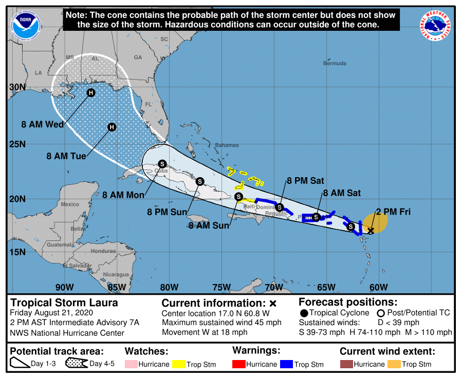
RZW EXEC: UNCERTAINTY IN T.S. LAURA FORECAST… RZW Exec partners, I hope you’re having a nice Friday. Below is a *highly detailed* explanation of where we are in the process of forecasting for Tropical Storm Laura, currently situated near the northernmost Leeward Islands. While the official forecast from the National Hurricane Center shows the potential for a hurricane to approach our local area next week, there is ample uncertainty in this idea. There is so much uncertainty that I’ve outlined 3 scenarios of what could happen below. Basically, we need the system to move westward and see if the center of circulation is going to be hindered drastically by Puerto Rico and Hispaniola before we can more accurately and precisely give more forecast details for what to expect locally.

RANGE OF SCENARIOS FOR T.S. LAURA IMPACTS FOR GULF COAST… Tropical Storm Laura is rapidly moving west-northwest this evening. Today there has been somewhat of a notable shift in the projected path for Laura, with the center of circulation expected to be basically hugging the northern coastlines of Puerto Rico, Hispaniola, and Cuba this weekend. This complicates the forecast a bit more as it is unknown how weak or strong Laura will be AND if the system can actually hold together long enough to reach the Gulf of Mexico. You’re reading that correctly: There IS a chance this whole system fades away this weekend. On the higher end of the range of possibilities, there also is a chance Laura becomes a hurricane as it moves through The Bahamas this weekend and approaches South Florida and the Florida Keys. Beyond that point, there is yet another range of possibilities as to just how strong Laura will be as it turns northward in the eastern Gulf of Mexico and potentially approaches our local area by Tuesday of the upcoming week. Complicating matters even more are that we may have a hurricane on the OTHER side of the Gulf (TD14/Marco-to-be) that could slightly alter the projected path of Laura midweek. Our big takeaway as of Friday evening is that we still do not know specifics as to what will happen next week. We may have impacts from a hurricane locally, but there is still a significant chance that we won’t. Let’s look at what we know and what we don’t know.

POTENTIAL LOCAL IMPACTS FROM LAURA IN SOUTH ALABAMA & NW FLORIDA… Local impacts will be possible Tuesday, Wednesday, and early Thursday from what is currently Tropical Storm Laura. Forecast confidence remains unusually low, as we don’t know just yet how much land interaction will degrade the storm over the next few days. While local impacts will be possible, it is too early to suggest specifics for any city or town across our region. At a minimum, I expect gusty winds at the immediate coast and high surf & rip currents at local beaches. Depending on the exact future track of Laura, potential local impacts may have to be adjusted significantly. Direct local impacts from TD14/Marco appear unlikely.

SHORT TERM UNCERTAINTY MAGNIFIES UNCERTAINTY NEXT WEEK… There is good confidence in the short term that Tropical Storm Laura will continue to move west or perhaps just north of due west through tonight. The center of Laura as of 1PM is located at 17.0N and 60.8W. That is about 175 miles east-southeast of the northernmost Leeward Islands. Laura has not strengthened much today, but it did strengthen this morning JUST enough to become a named storm with 40 mph winds. Based on some of the personal accounts of the NOAA Hurricane Hunters that I follow on Twitter and Instagram, there was some question as to whether Laura still has a low-level center of circulation as of late morning. Drier air to the north and atmospheric shear (changing of wind direction with height in the atmosphere) continue to take a toll on Laura this afternoon. There IS a chance over the next 12-24 hours that Laura may open up into a tropical wave and fail to remain a tropical cyclone. Obviously if that particular scenario panned out, odds would be significantly higher that the land masses of Puerto Rico, Hispaniola and Cuba could severely disrupt the system or perhaps dissipate it entirely. You can tell that the low confidence I have in the short term NO DOUBT complicates forecast confidence exponentially in 3-5 days. Why? Because if we can’t definitively say what will happen in the next 24-72 hours, it is hard to have a “starting point” for a forecast that starts in 72 hours if that makes sense. Error in the short term compounds and enhances error in the long term. This remains a very, VERY uncertain forecast. As I indicated in our video last evening, I would imagine we will have a much better understanding of the short term variables by tomorrow (Saturday) morning.

GENERAL IDEA FOR LAURA: NORTHWESTERN MOVEMENT… The one thing I can communicate with high confidence today is the overall, general idea that Tropical Storm Laura will continue to move west or west-northwest over the next 2-3 days. There is very little doubt Laura will bring heavy rain at times to the U.S. and British Virgin Islands, Puerto Rico, the Dominican Republic, Haiti, the Turks & Caicos, The Bahamas and Cuba. If we “zoom out” and look at this situation with a broad view, there is a high degree of confidence that Laura (or perhaps what is left of Laura, in some scenarios) will end up in the southern Gulf of Mexico.

LOW CONFIDENCE IN INTENSITY FORECAST… Along the way over the next 2-3 days as Laura moves northwest, the storm may degenerate into an open tropical wave, it may remain a disorganized tropical storm or perhaps even weaken into a tropical depression, OR if the center of circulation can reform to the north of the Greater Antilles, it may rapidly strengthen into a hurricane this weekend as it rapidly moves northwest. So again (just to drive this point home), Laura may be a weak area of low pressure, tropical depression, tropical storm, or hurricane once the storm reaches the Florida Keys and Florida Straits this weekend.

IMPACTS *LIKELY* IN FLORIDA KEYS… Impacts from Tropical Storm Laura are likely in the Florida Keys and parts of the southern part of Florida regardless of how strong the storm is early next week. Heavy rain, high winds, isolated tornadoes, storm surge, high surf, and flash flooding will all be concerns. Confidence is now high that the Keys could potentially have a range of impacts from Laura from early Monday morning through early Tuesday morning.

RANGE OF LAURA OUTCOMES BELOW… Clearly, the forecast for Tropical Storm Laura has short-term and long-term intricacies that complicate the forecast for this system. Unfortunately, other than the Florida Keys, Greater Antilles, and The Bahamas, we cannot conclusively say who will have impacts along the Gulf Coast region and who won’t. Below are THREE scenarios (a best case, a most likely as of this moment, and a worst case) we can look at to understand the range of impacts for our local area in south Alabama and northwest Florida.

BEST CASE SCENARIO – LAURA… The absolute best case scenario would be for Tropical Storm Laura to be absolutely destroyed and hammered by the high terrain of Puerto Rico, Hispaniola, and western Cuba. These islands have destroyed many a tropical storm and hurricane over the years and our best case scenario shows Laura degenerating into a remnant low tropical wave as it moves northwest toward the Gulf of Mexico. If what is left of Laura at that point emerges fractured and weak, the system won’t have as long of a time to strengthen before the system moves into the northern Gulf, somewhere between Texas and the Florida Panhandle next week. It is important to note that even in this best case scenario, Laura could be significantly degraded, emerge over the southeastern Gulf early next week, and then rapidly strengthen into a hurricane before landfall sometime in the middle of the week.

MOST LIKELY SCENARIO – LAURA… The official forecast from the National Hurricane Center paints a good picture of the most likely scenario, as 3PM on Friday. NHC calls for the center of Tropical Storm Laura to basically be right on top of the northern coastlines of Puerto Rico, Hispaniola, and Cuba. This partial land interaction will likely, at minimum, keep the strengthen of the storm steady and not allow for rapid intensification in the short term. Beyond this, model guidance has continued to trend farther WEST over the last 12-24 hours, meaning there is a good chance the NHC projected path (cone of uncertainty) will also shift a bit farther west in future advisories. While this could potentially signify good news for our local area, potentially avoiding the direct hit of a hurricane, two important caveats here: 1) It is FAR too early to say conclusively our local area won’t have direct impacts. Please don’t let your guard down this weekend. 2) EVEN IF the system moves inland farther west from us directly, that puts the entirety of our local area on the volatile eastern flank of the storm. Isolated tornadoes, gusty winds the immediate coast, storm surge, high surf, heavy rain, and flash flooding would all be concerns under this most likely scenario. The most likely scenario will change in the days ahead as we receive more data.

WORST CASE SCENARIO – LAURA… This worst case scenario is designed for south Alabama and northwest Florida. Keep in mind that a worst case scenario USUALLY does not happen in situations like this. This is one possibility in a range of possibilities. The worst case scenario basically would keep the center of circulation of Laura north of Puerto Rico, Hispaniola, and Cuba over the next 2-3 days with the system rapidly strengthening into a hurricane or perhaps a major hurricane as it approaches the Florida Keys and the Florida Straits. Once the system emerges into the Gulf as a formidable hurricane that hasn’t really been affected by much in the way of land areas, there could be a clear path to further strengthening. The system could ramp up to a powerful, major hurricane in the Gulf before approaching a northern Gulf Coast landfall sometime in the middle of the upcoming week. Local impacts for our area in that scenario, depending on the exact future track of Laura, could be extensive. Again, this remains an OUTLIER scenario as of now, but I feel it is important to communicate the RANGE of possibilities.

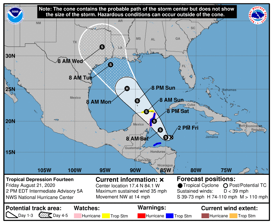
LET’S NOT FORGET ABOUT TD14/MARCO… Complicating the forecast for Tropical Storm Laura even more are the fact that models are dealing with another developing tropical depression in the western Caribbean Sea. I would suggest there is a very high chance Tropical Depression 14 will be upgraded tonight to Tropical Storm Marco, based on the latest visible satellite imagery. We will get more Hurricane Hunter aircraft recon data from the system later this evening. TD14/Marco will move northwest in the days ahead, likely crossing the northern part of the Yucatan Peninsula of Mexico Saturday night into Sunday. A Hurricane Watch and Tropical Storm Warning continue for parts of the Yucatan near Cancun. Once TD14/Marco emerges into the southern Gulf on Sunday, strengthening will likely commence. NHC ramps the system up to a category 1 hurricane in the west-central Gulf before weakening begins Monday night into Tuesday as southwesterly shear kicks in. Landfall of TD14/Marco will likely happen somewhere along the Texas or Louisiana coast. Right now, the cone of uncertainty extends from Corpus Christi, TX to Morgan City, LA. This includes Houston, Galveston, Beaumont, Lake Charles, and Lafayette (LA). These areas should be on guard for the potential for tropical storm or hurricane impacts starting as early as late Monday night, extending through Tuesday.

APP ALERTS… If you haven’t already downloaded the RedZone Weather app, now is a great time to do that. redzoneweather.com/app is the link to the free download. Once you have the RZW app installed on your iOS or Android device, be sure to visit the Alerts tab to turn on the specific notifications you’d like to receive. All notifications are handcrafted by me. No automation and we promise not to bug you!

NEXT UPDATE… I will have another detailed post later this evening. Have a great Friday evening!

Tap below to support this RZW sponsor!

5:45PM 8/18/2020 – RZW Exec

RZW EXEC: TROPICS BECOMING MORE ACTIVE… RZW Exec partners, good Tuesday evening to each of you! We have had an extended period of weather conditions that have been a bit more calm compared to the first half of the year. Over the next several weeks, our focus will largely be on the ongoing hurricane season. We are approaching the climatological peak of the Atlantic Hurricane Season on September 11. Right on schedule, we now have two tropical waves that will likely become tropical storms over the next few days. One is located in the eastern Carribean Sea near the Lesser Antilles and the other is located in the middle of the Atlantic Ocean, far away from any land areas at the moment. The tropical disturbance we will really need to focus on in the days ahead is the wave in the Caribbean, currently branded as INVEST 97L. This disturbance might move into the southern Gulf of Mexico early next week. It is too early to know if local impacts will happen. I will have further RZW Exec updates for you as needed in the days ahead. Below is our highly detailed, public post that will debut later this evening. As always, please let me know if you have any decision support needs or weather questions.

MULTIPLE TROPICAL WAVES LIKELY TO DEVELOP INTO TROPICAL STORMS SOON… There is now a high (70-90%) chance that multiple tropical storms will develop over the next 3-5 days. INVEST 97L is a tropical wave located in the eastern Caribbean Sea as of this evening. Development of this system is likely to happen once the tropical disturbance reaches the western Caribbean Sea, near or just west of Jamaica, this weekend. Beyond that, it’s truly anyone’s guess as to where 97L will go. This is a disturbance that warrants our attention as local impacts could become possible toward the end of next week IF (big IF!) the system moves toward our area. We are also monitoring a separate, distinct tropical wave (branded as INVEST 98L) in the Atlantic Ocean that has a high (90+%) chance of becoming a tropical storm in the next few days as it approaches the Lesser Antilles. There remains ample uncertainty as to just how close this developing system will get to the continental United States. Some model scenarios ultimately take 98L out to sea, while others show a system approaching South Florida in about a week. More details are below.

INVEST 97L IN THE CARIBBEAN SEA… The National Hurricane Center discussion summarizes 97L quite well: “A tropical wave over the eastern Caribbean Sea continues to produce an area of disorganized thunderstorms and gusty winds. This wave is moving quickly westward at about 20 mph and significant development is unlikely while it moves across the eastern and central Caribbean Sea during the next day or two. After that time, however, the wave is forecast to slow down, and a tropical depression will likely form late this week or this weekend when it reaches the northwestern Caribbean Sea.”

TIMING – INVEST 97L… The tropical wave in the eastern Caribbean Sea (INVEST 97L) is currently situated in a zone where no one in the U.S. needs to panic or be worried. This system is still 6-8 days out from any potential U.S. impacts IF any actually happen. 97L will likely become a tropical depression or tropical storm this weekend in the western Caribbean Sea. Early next week is when the system will likely be in the Bay of Campeche, near the Yucatan Peninsula, or be in the southern Gulf of Mexico. This is a tropical disturbance we need to be aware of, but it is too early to know if any specific U.S. impacts will happen and if so, where they will happen.

INVEST 98L IN THE ATLANTIC… The other tropical wave we are tracking this evening is INVEST 98L, located in the middle of the Atlantic Ocean between Africa and the Lesser Antilles. This tropical disturbance continues to be in an area where the Intertropical Convergence Zone (ITCZ) has a massive influence, thus it is hard to know exactly where the features of this tropical wave are specifically situated. From NHC: “An area of low pressure located about 1300 miles east of the Lesser Antilles is producing a concentrated area of showers and thunderstorms. Environmental conditions are conducive for development, and a tropical depression is expected to form within the next couple of days while the system moves west-northwestward at 15 to 20 mph across the central and western portions of the tropical Atlantic. Interests in the Lesser Antilles should monitor the progress of this system.”

APP… If you haven’t already, be sure to download the free RedZone Weather app to keep up with all the latest information on the world of weather in south Alabama and northwest Florida. redzoneweather.com/app is the link for the free download. Once you have the app downloaded to your iOS or Android device, be sure to visit the Alerts tab (lower right corner) and tap the large, yellow Alert Settings button to customize the alerts you would like to receive straight from me.

NEXT UPDATE… I’ll have your next detailed post about the tropics and our local weather forecast in my next morning video that will be posted by 7:15AM on Wednesday on Facebook and in the RedZone Weather app. Be sure to join me in the video for the very latest information. Have a great Tuesday evening!

Tap below to support this RZW sponsor!

3:26PM 6/5/2020 – RZW Exec

RZW EXEC: FRIDAY AFTERNOON TROPICAL STORM CRISTOBAL UDPATE… Cristobal is a tropical storm again as it moves north near the western coast of the Yucatan Peninsula on this Friday evening. Expected local impacts from Tropical Storm Cristobal across south Alabama and northwest Florida have not changed that much. Here are the talking points of the minor forecast changes:

1) Tweaked tornado risk to be a bit higher on Sunday evening into early Monday as the core of Cristobal makes landfall to our west.

2) New – Tropical Storm Watch for Alabama coastline and points west into MS and LA.

3) Added emphasis of potential for minor coastal flooding at the Alabama and NW Florida beach zones.

4) Added detailed information about the new Storm Surge Watches in effect to our east and to our west.

5) Re-emphasis on main potential hazard being heavy rain and flash flooding.

Below is the highly detailed post that will debut later this evening. As always, please let me know if you have any specific needs concerning decision support for your business or organization.

HIGHLY DETAILED POST: LOCAL IMPACTS FROM CRISTOBAL EXPECTED SUNDAY P.M. INTO MONDAY… Brief tornadoes, gusty winds at the coast, and heavy rain are expected on Sunday into Monday as the core of Tropical Storm Cristobal likely passes our area to the west. Most of the impacts will on the eastern side of this tropical storm, meaning our area will be in the zone where impacts happen. Heavy rain and flash flooding remain the biggest concerns, but chances have increased that a few tornadoes may happen on Sunday into Monday. Gusty winds, large waves, and dangerous rip currents will be concerns at the immediate beach and coastal zones. The National Hurricane Center issued a Tropical Storm Watch for all of the Alabama coastline, extending westward to Intracoastal City, Louisiana earlier today. That means if you are in any part of Baldwin or Mobile counties south of Interstate 10, you’re now under a Tropical Storm Watch. We have quite a list of updates below, with specifics on potential local impacts in south Alabama and northwest Florida…

1PM ADVISORY – TROPICAL STORM CRISTOBAL… Cristobal re-strengthened, as expected, into a tropical storm as of the 1PM Friday advisory. The center of circulation remains over the northwestern corner of the Yucatan Peninsula. Eastern Mexico has been drenched with heavy rain and numerous flash flooding issues over the last few days. These issues will slowly begin to subside as the center of Cristobal moves north tonight into Saturday morning. The storm is now moving at 12 miles per hour to the north, which is a significant increase in forward speed. Now that Cristobal is moving, it is expected to reach the central Gulf by Saturday evening. Landfall in Louisiana (more on that below) is expected Sunday evening.

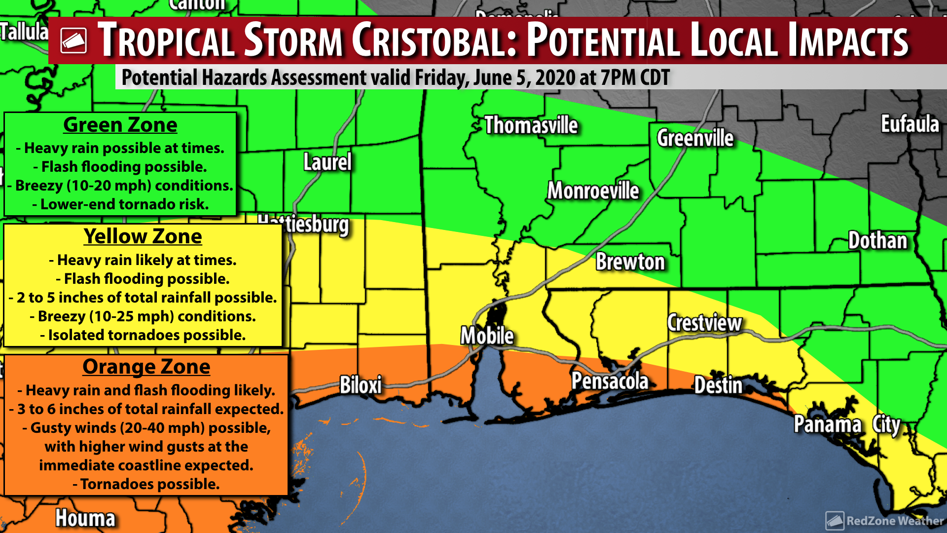
IMPACTS: OVERALL LOCAL ASSESSMENT – CRISTOBAL… Overall, our messaging on potential local impacts in south Alabama and northwest Florida has not changed that much. This is a good indicator that forecast confidence is now very high. The most significant issue from Cristobal locally will be heavy rain and the potential for flash flooding. The flash flooding risk will be greatest across the southern half of our local area, aka in coastal counties. Heavier rain may start as early as Saturday evening and continue in multiple rounds through Tuesday. Gusty winds of 20-30 mph sustained winds are expected near the coast. Coastal flooding, rip currents, and large waves are all concerns at all Alabama and northwest Florida beaches.

IMPACTS: BRIEF TORNADOES POSSIBLE… The eastern side of Cristobal will be the side that affects our local area in south Alabama and northwest Florida. This means we will be on the side of the storm where the flow is out of the south, around the large counter-clockwise circulation. Due to this, we could have a few spin-up tornadoes. The greatest tornado risk locally will be Sunday P.M. into Monday A.M. If there is one thing I’ve learned about tropical cyclones affecting our local area over the last few years, it is that we should expect spin-up tornadoes. I would not be shocked if a few brief tornadoes happen locally before AND after the timeframe mentioned. What that means for you is that we all need to have a way to get tornado warnings from Sunday morning through Tuesday morning, including all of Sunday and all of Monday. I realize that is a long timeframe, but it is better to be prepared and know that there is a possibility of a few tornadoes than to not be aware at all. Keep in mind that most tropical-induced tornadoes are brief and do not last long, but as always, if a tornado affects YOU, it’s a big deal. Have a way to get the warnings!

IMPACTS: GUSTY WINDS NEAR THE COAST… Cristobal likely will not be a memorable tropical storm because of widespread wind damage. Could there be isolated wind damage? Maybe, but the overall trend supports Cristobal being more of a heavy rainmaker with flash flooding being the main concern. The National Hurricane Center has included the southern halves of Baldwin County and Mobile County in southwest Alabama in a Tropical Storm Watch, where winds may gust up to 40-50 mph at times. Most of the winds near the coast probably won’t be that strong, but there could be brief gusts up to those levels. Breezy (10-20 mph) conditions are expected across northwest Florida and inland areas of south Alabama with no major wind impacts expected.

IMPACTS: HEAVY RAIN & FLASH FLOODING… If there is one potential impact that gives me quite a bit of concern with Cristobal, it is the potential for heavy rain and flash flooding across our region. Clearly the greatest risk of flash flooding will set up across coastal counties. This means if you’re in any part of Baldwin, Mobile, Escambia (FL), Santa Rosa, Okaloosa, or Walton counties, you may pick up 4-6” of rain in total with this event. The ongoing drought will likely be alleviated or eliminated, but because the ground has been so parched in many cases, the soil absorption rate won’t be very high. This could exacerbate flash flooding as we go into Sunday and Monday.

IMPACTS: COASTAL FLOODING, STORM SURGE, RIP CURRENTS, LARGE WAVES… It seems like every, single time we have any type of tropical system around here, we get several boneheads that insist on getting into the water at local beaches and ignoring the red flags. It cannot be stressed enough: Please don’t risk your life by getting out in the water during a tropical storm. As I’ve said in past storms, this is common sense to 99.9% of people, but there are some folks who defy the recommendations. Rip currents will be numerous and waves will be large. Please don’t get in the water from Sunday through Tuesday morning. I *love* the beach as much as anyone (and I especially love being in the water!) but it just isn’t a good idea this weekend into next week. Coastal flooding is possible along Alabama and northwest Florida coast with inundation of 2 to 3 feet Sunday through Monday afternoon, especially around the time of high tide.

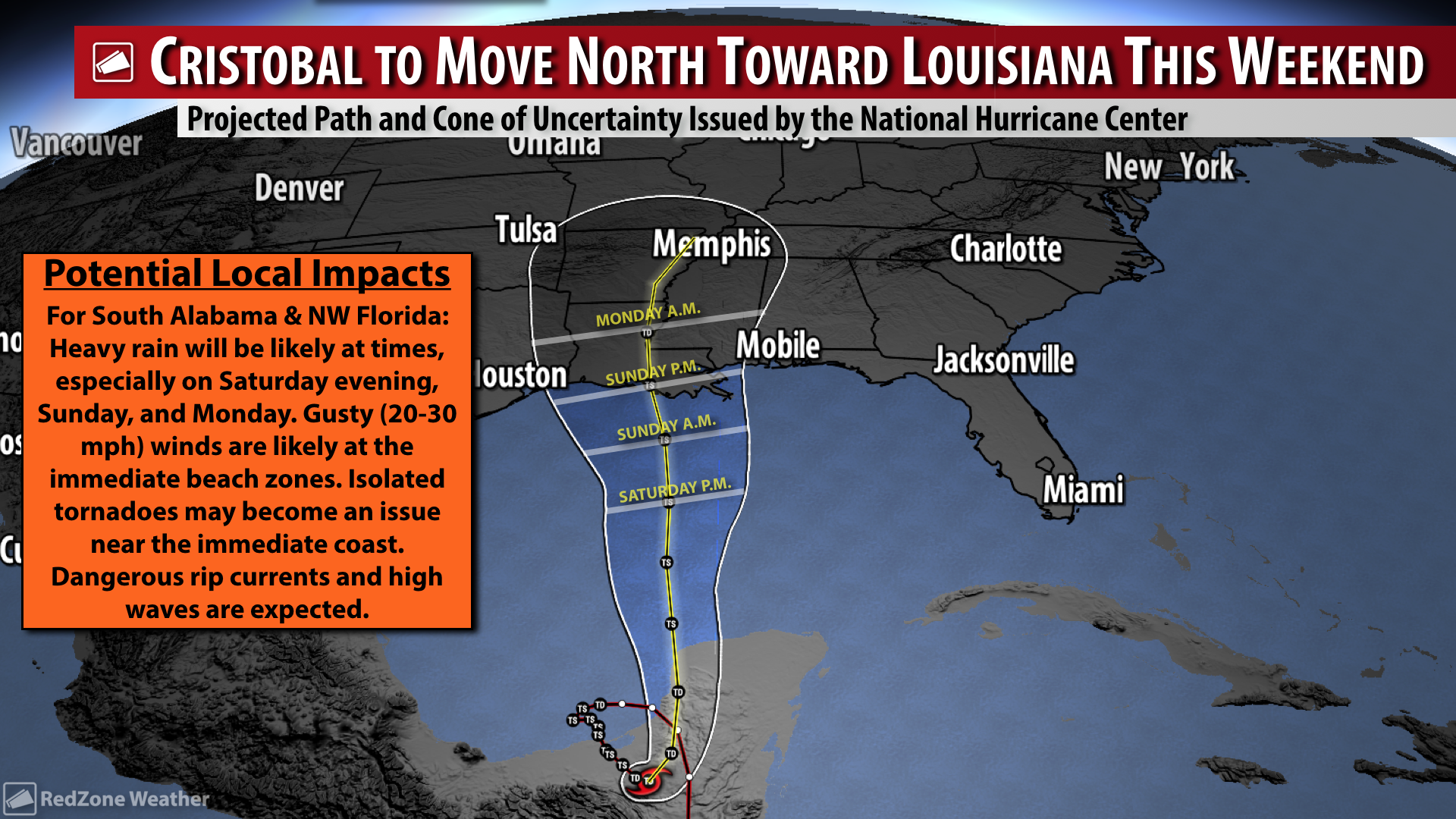
CRISTOBAL TO MOVE NORTH TONIGHT, SATURDAY, INTO SUNDAY… Cristobal has started its trek northward and will emerge over the warm waters of the southern Gulf tonight from the Yucatan Peninsula. Modest strengthening is expected as the system crosses the Gulf and moves toward Louisiana. One limiting factor that will likely prohibit rapid strengthening is an increasing amount of southwesterly shear over the system on Saturday into Sunday. Another factor that will likely keep Cristobal in check will be a large amount of drier air on the western side of the circulation that will likely be wrapped into the system before landfall on Sunday evening. NHC suggests the system will be a tropical storm packing maximum sustained winds of 60 mph at the time of landfall. Obviously there is an off chance Cristobal briefly becomes a hurricane before landfall, but that should be considered an outlier scenario as of now.

LANDFALL IS EXPECTED IN LOUISIANA… Confidence is now high that the center of Tropical Storm Cristobal will make landfall in Louisiana, probably on Sunday evening or perhaps very early in the morning hours of Monday (before 6AM). Keep in mind that impacts WILL extend well beyond (and mostly well EAST) of the landfall point. Once the storm makes landfall, it is expected to move north or northwest toward central Louisiana, western Mississippi, and Arkansas into early next week.

TROPICAL STORM WATCH FOR ALABAMA BEACHES & POINTS WEST… The National Hurricane Center has issued a Tropical Storm Watch valid until further notice from the Alabama-Florida border (at the FloraBama) westward to Intracoastal City, Louisiana. This includes Lake Pontchartrain and Lake Maurepas. All bays and inlets for this stretch of coastline are also included, including Mobile Bay and the Mississippi Sound. A Tropical Storm Watch means tropical storm conditions (including wind gusts in excess of 39 mph) are possible in the watch area within the next 48 hours.

STORM SURGE WATCH TO OUR EAST AND TO OUR WEST… NHC has also posted a Storm Surge Watch to our east and to our west. This Storm Surge Watch is in effect for these areas and not in effect for our local area due to the geography and slants of the coastlines in relation to where the center of Cristobal is expected to move onshore. There is a Storm Surge Watch in effect from Indian Pass, FL southward to Arepika, FL. There is a separate Storm Surge Watch in effect from Grand Isle, LA eastward to Ocean Springs, MS. Lake Borgne is also involved. A Storm Surge Watch means there is a possibility of potentially life-threatening inundation at the immediate coast, from rising water moving inland from the coastline, in the indicated locations during the next 48 hours.

FLASH FLOOD WATCH LIKELY TO BE ISSUED SOON… There will likely be a Flash Flood Watch needed for coastal counties (at a minimum) valid for Sunday into Monday. NWS Mobile has not posted that yet, but I expect a Flash Flood Watch to be issued soon. 3 to 6 inches of rainfall in total is expected locally with greater rain amounts near the coast.

RAIN TO LINGER INTO MIDDLE PART OF NEXT WEEK… Even after the center of Tropical Storm Cristobal makes landfall on Sunday into early Monday to our west, the flow out of the south will keep our area in a zone where moisture is abundant and supportive of numerous showers and thunderstorms on Tuesday into Wednesday of the upcoming week. We should finally get a break from the rain as we approach Friday of the upcoming week.

APP… Many updates will be posted throughout the weekend in the RedZone Weather app. redzoneweather.com/app is the link for the free download. Be sure to visit the Alerts tab (bottom right corner) and tap the large, yellow “Alert Settings” button to customize the alerts you’d like to receive from me. If you like a lot of info, be sure to toggle ON Low-Level Alerts.

Tap below to support this RZW sponsor!

3:30PM 6/4/2020 – RZW Exec

RZW EXEC: CRISTOBAL – THURSDAY UPDATE… RZW Exec partners, good Thursday evening. Cristobal has weakened to tropical depression status over the mountainous terrain of Mexico and Guatemala. This was expected as land interaction continues. Overall, the forecast for this tropical system remains essentially unchanged from yesterday. This is a good thing as confidence in the forecast continues to grow. Cristobal will likely begin to move northward later tonight or on Friday. The system will likely strengthen gradually as it marches across the Gulf of Mexico from the Yucatan Peninsula toward Louisiana. The National Hurricane Center continues to suggest Cristobal will be a moderate tropical storm (max. winds near 60 mph) at landfall in Louisiana on Sunday or early Monday morning. We will continue our public messaging suggesting the greatest hazard for our local area will be heavy rain that could lead to flash flooding this weekend. Gusty winds (20-30 mph) will be possible at the immediate beaches. There could be a risk of a few isolated, spin-up tornadoes, although confidence in this idea remains a bit more uncertain. In addition, dangerous rip currents and large waves (beach erosion) will be a concern for the immediate coast. Looking at the positives in this situation, there is a high chance that our local drought conditions will continue to improve in part due to Cristobal.

Overview: Tropical Storm Cristobal (currently a tropical depression, but expected to re-strengthen into a tropical storm) will make its closest approach to our local area Sunday night into Monday. Cristobal will bring a period of wet/stormy weather to our region with heavy rainfall and flash flooding being the main concern. Isolated, brief tornadoes may become an issue near the immediate coast. At this point in the forecast, high winds are NOT expected locally, although gusty (20-30 mph) winds will be possible near the coast on Sunday, Monday, and into Tuesday.

Threat Levels & Locations: ALL of south Alabama and northwest Florida will have the potential for heavy rain and flash flooding this weekend into early next week. The tornado risk will likely be confined to the immediate coastline, although a conditional risk of isolated tornadoes may set up across west Alabama. Gusty winds will happen at the immediate coastline.

When: Heavy rain will be possible from Saturday through Tuesday. The risk of isolated tornadoes will be greatest Sunday into Monday.

Potential Hazards: Heavy rain and flash flooding will be the main concern. Isolated tornadoes will be possible, especially near the coast. Coastal flooding and beach erosion will be possible. Dangerous rip currents and large waves are expected at all local beaches.

Forecast Confidence: High. Model guidance has continued to point to a Louisiana landfall for Tropical Storm Cristobal, thus it looks like our overall impacts discussed above won’t change that much.

As always, please let me know if you have any questions or have specific decision support needs. Below is the public graphic that will be posted later today. Have a great weekend!

Tap below to support this RZW sponsor!