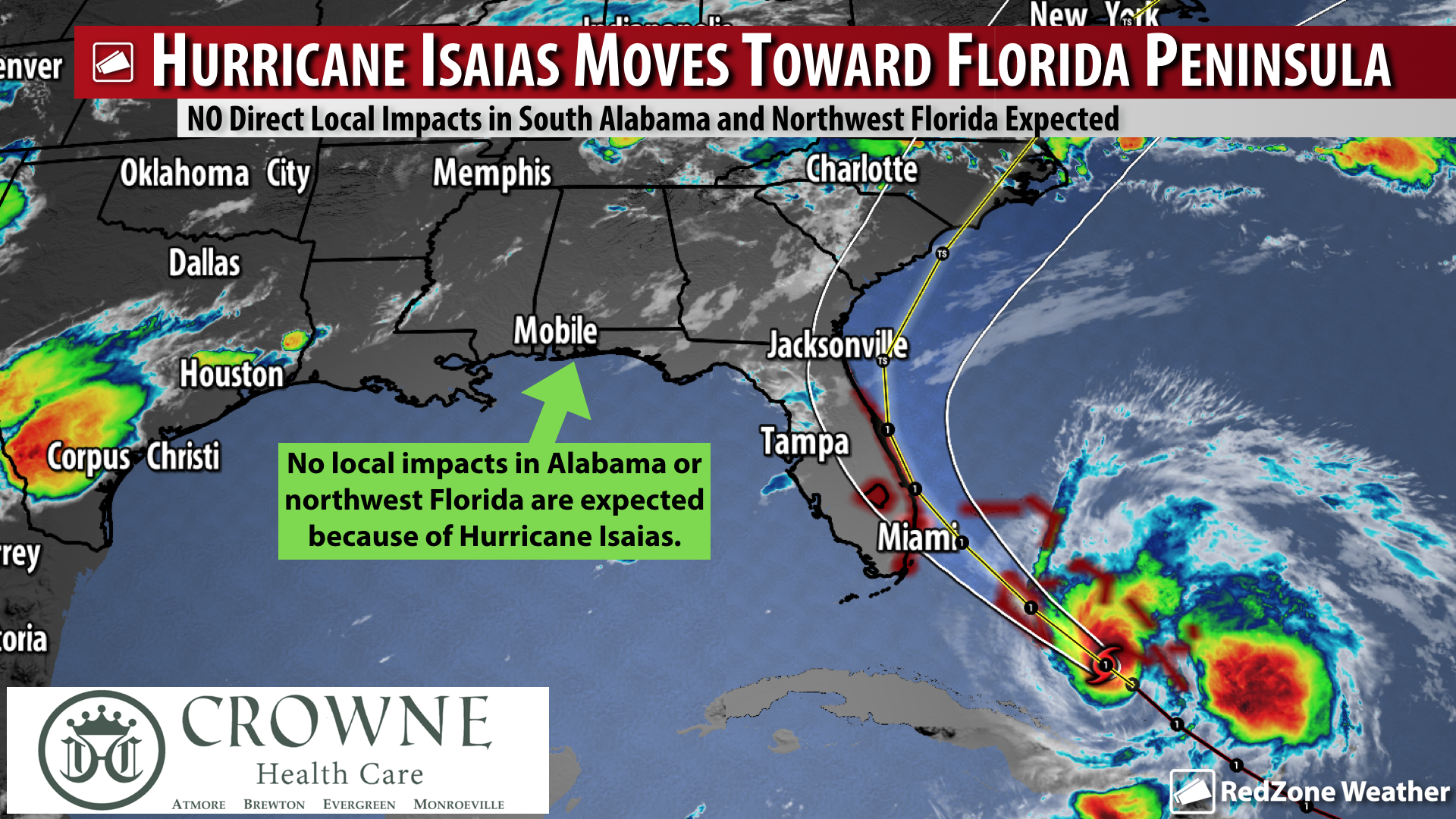
MOSTLY SUNNY TODAY & SUNDAY; HURRICANE ISAIAS NEAR SOUTH FLORIDA… Hot, mostly sunny conditions are expected across south Alabama and northwest Florida on this Saturday. Rain chances today remain very low (10-20%) across the region. High temperatures will approach 95 degrees in many areas locally with heat index values likely to be between 100 and 105 this afternoon. If you’re headed to a local beach, creek, or getting out by the pool today, grab that sunscreen as the UV Index will be sky high. We continue to track Hurricane Isaias as it approaches the Florida Peninsula (not the Panhandle where we are, but the Peninsula). A Hurricane Warning is in effect for much of the east (Atlantic) coast of Florida. It is going to be a close call as to if the center of Hurricane Isaias makes landfall along the Atlantic coast of Florida. What is NOT a close call, however, is that Isaias definitely won’t be a direct local issue for Alabama or northwest Florida. No impacts are expected in our region. We are also watching a weak, short-lived tropical depression near the African continent that is likely to completely dissipate later today or tonight. Let’s look at your forecast details…
LOCALLY, PLENTY OF SUNSHINE THIS WEEKEND… Sunshine is the word today across south Alabama and northwest Florida. High temperatures will be in the mid-90s with a very low chance of rain. We could have a few more clouds and perhaps a few more in the way of showers and thunderstorms on Sunday, but I expect rain chances to overall be pretty low. 10-20% chance of rain today and then a 20-30% chance of rain on Sunday sounds reasonable at this point. High temperatures will remain in the mid-90s on Sunday.
HURRICANE WARNINGS FOR ATLANTIC COAST OF FLORIDA… A Hurricane Warning has been issued for a long stretch of the Florida Atlantic coastline. The Hurricane Warning extends from Boca Raton northward to the Volusia/Brevard County Line. A Hurricane Watch or Tropical Storm Watch will likely be issued for parts of the South Carolina and North Carolina coast later tonight or on Sunday.
ISAIAS TO POTENTIALLY MAKE LANDFALL IN SOUTH FLORIDA… There still is some question as to if Hurricane Isaias will actually make landfall in the Florida Peninsula perhaps near or north of Miami. Regardless of if this happens or not, it looks like the center of circulation associated with Isaias will be very close to the eastern coast of Florida as the system moves north. This means that hurricane impacts, including high wind gusts, heavy rain, and high waves will all be concerns for the east coast of Florida.
ISAIAS IMPACTS LIKELY IN CAROLINAS MONDAY INTO TUESDAY… Hurricane Isaias will first affect Florida, but next in line for the system will be an encounter with South Carolina and North Carolina on Monday into Tuesday as the system begins accelerating to the northeast. The system will likely be a strong tropical storm and not a hurricane when it passes through the eastern part of the Carolinas, per the latest forecast from the National Hurricane Center. Heavy rain, flash flooding, isolated tornadoes, high wind, and high waves will all be a concern. Isaias is expected to move through the Northeast U.S. on Tuesday into Wednesday.
TROPICAL DEPRESSION 10 NEAR AFRICAN COAST… A tropical wave moved off the African coast on Thursday and briefly flared up to tropical depression status late on Friday. The depression is in an area where sea surface temperatures are not conducive for much more (if any) development. The depression is moving north at 5-10 mph just northeast of the Cabo Verde Islands.
FEW STORMS POSSIBLE BY MIDWEEK… We return to more of a seasonal summer pattern as we get into the middle part of the upcoming week. High temperatures will remain in the mid-90s with morning lows in the low-70s. Rain chances by Tuesday into Wednesday will be in the 40-50% chance range.
APP… Be sure to download our free RedZone Weather app if you haven’t done so already. redzoneweather.com/app is the link where you can download the app for your iOS or Android device. Once you have the app downloaded, be sure to visit the Alerts tab in the lower right corner of the app to select the specific notifications you would like to receive straight from me.
I will have updates posted throughout the day and into this evening as needed in the RedZone Weather app. Have a great Saturday!
