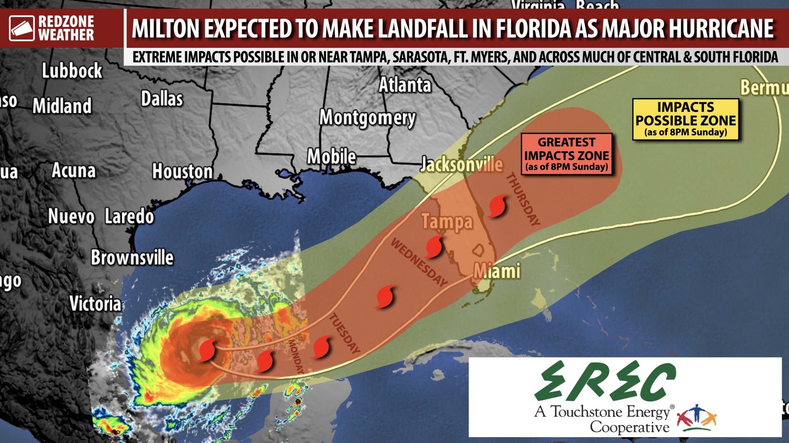
MAJOR IMPACTS LIKELY FOR PARTS OF CENTRAL & SOUTH FLORIDA DUE TO HURRICANE MILTON… Hurricane Milton is expected to be a major, category 3 or category 4 hurricane at landfall on Wednesday when the storm slams into the Florida Peninsula. Some of the higher-end intensity guidance is even higher, suggesting the possibility of Milton being a category 4 or 5 storm near landfall. The landfall point will very likely be along the west coast of Florida from Cedar Key to Everglades City, FL. Extreme storm surge will be a concern near Tampa Bay, Sarasota, Ft. Myers, and Naples, along with many other communities near the western Gulf Coast of Florida. High wind impacts will be a problem near the coast and farther inland in parts of the Florida Peninsula. Flooding and tornadoes are also possible Wednesday into Thursday. Hurricane Milton is NOT expected to cause major, direct issues in Alabama or northwest Florida.
LOCAL IMPACTS DISCUSSION – ALABAMA & N.W. FLORIDA… No significant, direct impacts are expected due to Hurricane Milton in Alabama or northwest Florida. Much of the week will be sunny and dry locally with cooler temperatures expected later this week. There will be a high risk of rip currents and high waves at the Alabama and Florida beaches through the end of the week and perhaps into the weekend as well.
WORST CASE SCENARIO POSSIBLE FOR TAMPA BAY; EXTREME STORM SURGE LIKELY… One of the scenarios that would be, quite frankly, the worst case scenario for the Tampa Bay region is if the core/center of the hurricane makes landfall just north of Tampa Bay. That would mean the Tampa Bay area (along with St. Petersburg, Sarasota, Clearwater, Largo, Longboat Key, Bradenton, Ruskin, Siesta Key, and surrounding areas) would be on the southern side of the circulation where the extreme wind would be out of the west/Gulf. This would funnel a drastic, perhaps historic, amount of storm surge into the Tampa Bay area. Keep in mind, many of these communities just had some of their worst storm surge on record just a few weeks ago with Hurricane Helene, even though the core of Helene was offshore. That flow out of the west piled up a substantial amount of storm surge along the West Coast of Florida. This storm could be even worse, depending on exactly where the center of the storm moves onshore. If the center of Hurricane Milton moves on shore south of Tampa but north of Cape Coral/Ft. Myers, that would point to a potentially devastating storm surge for Ft. Myers, Cape Coral, and Naples. Those areas continue to recover from Hurricane Ian that was so horrible for those specific communities in 2022. Regardless of where the center of Hurricane Milton comes ashore, the storm surge is expected to be a major problem.
HIGH WIND IMPACTS NEAR THE COAST AND INLAND AS WELL… Much will depend on exactly where the center of Hurricane Milton makes landfall. Widespread wind damage and power outages will be possible across parts of central and south Florida. This does not JUST apply to coastal areas. Inland places like Orlando, Lakeland, Winter Haven, Sebring, Apopka, Sanford, Clermont, and The Villages should be ready for the potential for widespread power outages and downed trees, again, depending on the exact future track of Hurricane Milton.
FLOODING & TORNADOES ALSO POSSIBLE… In addition to a pronounced storm surge and high wind threat, I am also concerned about the potential for widespread flooding across the Florida Peninsula. 5 to 8 inches of total rainfall is expected over the next 5-7 days. This will lead to flash flooding being possible. Isolated tornadoes will also be a concern perhaps as early as late Tuesday night into Wednesday and Thursday as the core of Hurricane Milton approaches from the southwest.
COOLER WEATHER LOCALLY LATER THIS WEEK… It almost seems unreal to think that while our friends in the Florida Peninsula may be dealing with a historic, damaging hurricane, those of us in south Alabama and northwest Florida will have one of the nicest weather weeks we have had in quite some time. High temperatures will be in the low-80s and perhaps even upper-70s later this week. Low temperatures will be in the 50s by the end of the week. Nice, sunny days are expected each day this week.
I will have a detailed look at Hurricane Milton AND a look at what you can expect in terms of local temperatures in the next regularly scheduled RedZone Weather forecast video that will be posted by 7:15AM tomorrow morning. Hope you’ll join us for that!
Have a good Sunday evening!
