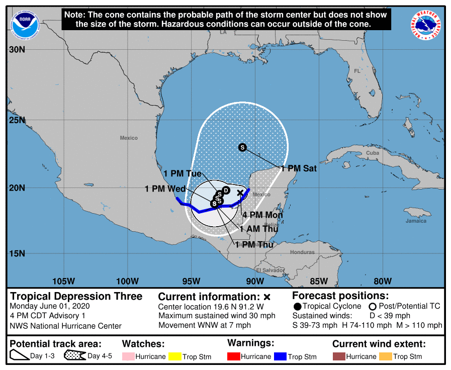
TROPICAL DEPRESSION 3 FORMS IN SOUTHERN GULF… The National Hurricane Center has initiated advisories on Tropical Depression Three, located in the southern Gulf of Mexico. This system has rapidly evolved today and organized to tropical depression status. TD3 will likely become Tropical Storm Cristobal in the hours ahead. The official forecast for TD3/Cristobal-to-be calls for the system to meander around the Bay of Campeche and southern Gulf for the next few days. Interestingly, if TD3 becomes a tropical storm over the next 3 days, this will be the earliest formation of the third named storm in an Atlantic Hurricane Season. The current record for the earliest 3rd named storm was Tropical Storm Colin in 2016.
LOCAL IMPACTS – TO BE DETERMINED… This remains on point from yesterday: There is a chance that NO local impacts across south Alabama and northwest Florida ever happen because of this system. We still are a few days out from knowing conclusively whether direct local impacts will happen. Uncertainty at this phase of development IS expected and details will come more into focus over the next few days. The MOST likely scenario, as of Monday, June 1, is that we will have slightly increased rain chances during the upcoming weekend. There could be a chance of a few stronger storms involved, depending on the exact track of what will likely be Tropical Storm Cristobal at that point. Please check back with me over the next few days as we continue to get more information.
RAIN CHANCES HIGHER LOCALLY, BUT NOT BECAUSE OF TD3… Our rain chances are set to rise as we get into the middle part of the week, but not because of direct influence from Tropical Depression 3/Cristobal. The showers and thunderstorms that pop up tomorrow, Wednesday, into Thursday are daily convection driven by the seabreeze that are all too common this time of year across our region. Storms will produce localized areas of heavy rain, gusty winds, and intense cloud-to-ground lightning, BUT widespread severe weather is not expected. Rain chances locally will increase throughout the week.
APP… Many updates will be posted over the next few days in the RedZone Weather app concerning this developing tropical system. redzoneweather.com/app is the link for the free download. Be sure to visit the Alerts tab (bottom right corner) and tap the large, yellow “Alert Settings” button to customize the alerts you’d like to receive from me. If you like a lot of info, be sure to toggle ON Low-Level Alerts.
I’ll have more details as needed in the RedZone Weather app in the hours ahead. My next detailed forecast video will be posted by 7:15AM on Tuesday. Be sure to check in with me tomorrow morning for the very latest information.
