
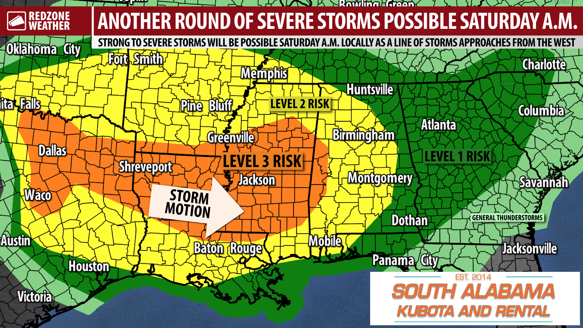
STORMS AHEAD FRIDAY; SEVERE STORMS POSSIBLE SATURDAY MORNING… Two more rounds of thunderstorms are ahead for south Alabama and northwest Florida. We had quite a bit of rain and a few thunderstorms this morning, but fortunately we did not have any tornado warnings locally. That result was within expectations for the Level 1 (out of 5) risk that was in place. Tomorrow into Saturday, the risk ramps up. The Storm Prediction Center has a Level 3 (out of 5) enhanced severe weather risk in place for parts of Mississippi and west Alabama. Much of our area remains involved in the Level 2 (out of 5) risk. One round of thunderstorms will likely happen during the daytime hours of Friday ahead of a more significant line of strong to severe storms slated to move through our region likely in the morning hours of Saturday. Heavy rain, damaging straight line winds, tornadoes, and large hail will be concerns on Saturday morning as this line of storms moves by. A few more Thursday evening forecast notes are below.
QUIET OVERNIGHT INTO EARLY FRIDAY… Tonight, no significant weather activity is expected across the region. There could be a few showers at times toward dawn and maybe a thunderstorm or two closer to the coast, but the overall threat of stronger storms won’t really ramp up until after sunrise Friday. Overnight lows will be in the low- to mid-60s.
STORMS TO POP UP TOMORROW IN THE DAYTIME HOURS… Showers and thunderstorms may get an early start in coastal communities on Friday. The overall coverage of thunderstorms will increase across the region throughout the day on Friday, although storms may be fairly scattered in nature throughout the day. There will be a few peeks of sunshine in the mix as well. Any thunderstorms that become large and tall will quickly become capable of producing very heavy rain, lots of lightning and loud thunder, and even small hail. The overall tornado risk on Friday remains quite low.
LEVEL 3 (OUT OF 5) RISK DRIVEN BY DAMAGING WIND THREAT… The Storm Prediction Center continues to include parts of west Alabama, much of Mississippi, southern Arkansas, and northern Louisiana in their Level 3 (out of 5) enhanced severe weather risk technically valid from 6AM Friday to 6AM on Saturday. This Level 3 risk is in place mainly due to the enhanced potential for damaging straight line wind gusts in the strong to severe line of storms that is expected to move from west to east late in the day on Friday into Saturday morning. Large hail is also a real concern. The overall tornado threat is not zero (by any stretch!) but it also is not particularly high. Often when we have these QLCS/squall line/MCS events, damaging winds can be just as bad as a weak tornado. It is important that we take the severe thunderstorm warnings seriously with this event as downed trees and tree branches will be the main concern.
SEVERE STORMS POSSIBLE LOCALLY SATURDAY MORNING… This developing line of storms will first set up to our west on Friday, before moving east and approaching west Alabama likely early in the morning hours of Saturday. More details about timing are below. The main hazards locally will be damaging wind gusts, hail, heavy rain, and the potential for a tornado or two. As always, if we happen to have tornado warnings locally, we will go into our live video coverage to bring you the very latest.
SEVERE WEATHER TIMING – SATURDAY MORNING… 5AM to Noon is the seven hour window when strong to severe thunderstorms will be most likely to happen across south Alabama and northwest Florida on SATURDAY morning. Rain could persist into the early afternoon hours, but clearing skies are expected in the afternoon and evening hours as storms continue to move eastward and out of our local area.
CLEARING SKIES IN THE EVENING HOURS OF SATURDAY… Storms should exit our area to the east by the late morning and early afternoon hours of Sunday. I expect most areas to be drying out by 3-4PM. Temperatures will be in the upper-60s by 7PM most likely.
TRENDING DRIER FOR SUNDAY INTO MONDAY… There is a fairly high chance that Sunday and Monday could be the driest days overall out of the next 7 days. Keep in mind that a rogue shower or two on Sunday into Monday cannot completely be ruled out, but rain chances will be much lower compared to today and Saturday. High temperatures on Sunday and on Monday will be in the low-80s.
REDZONE WEATHER APP ISSUE NOTED… I have had a few reports over the last 18 hours or so of a strange issue happening in the RedZone Weather app. Basically, it seems the tweets I post on Twitter that are visible in the app are rendering incorrectly. You can see the text and click the link to view the image/animations I post, but you should not have to do this. All of the content SHOULD be visible without you having to take any action. I can confirm the issue is happening because I am seeing it on my copy of the app as well. I have contacted our app development team about the issue and they are looking into it now. As a workaround until this issue is resolved, I will be doing more “native posting” in the app until the severe weather risks end. I should emphasize that this issue is isolated and does NOT affect our ability to come on Facebook Live or in the video stream of the app to bring you uninterrupted live coverage. That is a totally separate, “mission critical” system that is not affected by this bizarre issue. Thanks for your patience as we get this fixed and thanks for using our app!
NEXT VIDEO… My next detailed video and text discussion will be posted by 7:15AM on Friday morning. Until then, more updates will be posted in the RedZone Weather app. Have a great evening!