
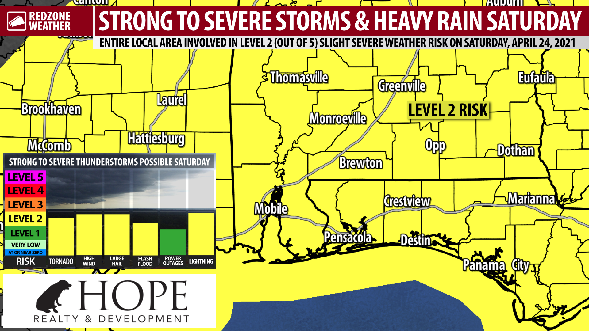
STRONG STORMS & HEAVY RAIN AHEAD FOR SATURDAY; LEVEL 2 (OUT OF 5) RISK… Strong to severe thunderstorms capable of producing damaging wind gusts, tornadoes, large hail, and flash flooding will be possible on Saturday. The Storm Prediction Center continues to include our entire local area in south Alabama and northwest Florida in their Level 2 (out of 5) slight severe weather risk valid for this Saturday, April 24. Strong storms and heavy rain may be possible in the early morning hours of Saturday ahead of a stronger round of storms in the afternoon and evening hours. More details about timing are below. Before we get to the severe weather setup on Saturday, we have an unseasonably cold night ahead. Overnight lows around 6AM Thursday will be near 40. More details are below.
TORNADOES, DAMAGING WINDS, LARGE HAIL POSSIBLE SATURDAY… Every severe weather event is unique, but the situation setting up for Saturday is a classic April severe weather setup for the Deep South. This means that tornadoes, damaging wind gusts, large hail, and flash flooding will all be possible in the strongest of the storms. The greater tornado risk may set up farther inland, particularly in our inland counties and points north, in the afternoon and evening hours of Saturday.
HEAVY RAIN AXIS MAY SET UP FARTHER INLAND… Model guidance today has pointed to the heavier rain amounts for areas north of our local area, in parts of central Mississippi and central Alabama where 2-3 inches of rainfall in total may happen. Rain amounts for our local area have actually trended down a bit. Most spots locally on Saturday are expected to pick up between 0.5″ and 2″ of rain in total. All of the rain will likely exit our region by late Saturday evening, paving the way for a dry Sunday and Monday.
SEVERE WEATHER TIMING – SATURDAY… Two distinct rounds of heavy rain and strong storms may happen on Saturday. The first round of heavy rain will feature a lower-end severe weather risk on Saturday in the early morning hours, probably from 2AM to 7AM. This round of rain and storms may be under severe limits. These first storms will be firing up along a warm front that will be moving north across the region. The next, potentially more significant round of thunderstorms will likely fire up in the late morning hours and extend into the afternoon and evening hours. 11AM to 8PM will be when the second and final round of thunderstorms will be ongoing. There is a chance our area may get an “all clear” well before 8PM, but I cannot guarantee that. We will be able to resolve some of the specifics regarding timing as we get closer to the event.
COLD TEMPERATURES TONIGHT… Ahead of the severe weather risk setting up for Saturday, we will have unseasonably cold temperatures across the region tonight into early Thursday morning. Overnight lows by daybreak Thursday are expected to be in the low-40s. Some locales north of U.S. Highway 84 may briefly dip into the upper-30s around 6AM tomorrow morning. No freezing temperatures are expected, but patchy areas of frost farther inland cannot completely be ruled out. Temperatures will quickly rebound into the upper-60s by the late morning hours of Thursday.
APP ALERTS… redzoneweather.com/app is the link where you can download the free RedZone Weather app. We post brief updates throughout each day in the app, keeping you up-to-date about the latest happenings in weather across south Alabama and northwest Florida. Once you have the free app downloaded to your iOS or Android device, be sure to visit the Alerts tab (lower right corner) then tap the large, yellow Alert Settings button to customize the alerts you would like to receive straight from me.
I will have your next full forecast video posted by 7:15AM tomorrow (Thursday) morning. Until then, more updates will be posted in the RedZone Weather app. Have a nice Wednesday evening!